LoJ: Not Ranked / 13,243' Notch Mountain

Peak Summary
Notch Mountain is a named but still unranked summit (even though Lidar measurements added 6 feet of elevation) located NE of Mount of the Holy Cross. Vehicle access is by the Tigiwon Road out of Minturn and is accessible to most passenger vehicles, however, depending on road maintenance & condition, some extra clearance may be advisable. There are two routes; one uses the Fall Creek and Notch Mountain Trails and the other uses the Half Moon Pass Trail that is the primary access for Mount of the Holy Cross. Both trails begin at the same trailhead location. Summer weekends can be over-crowded and camping opportunities very limited. The Notch Mountain Trail route is Class 2+ and the Half Moon Pass route is Class 2. For information regarding the Notch Mountain route, see UN 13,253 (previously 13,248) and read about the alternate descent route which will take hikers through the notch and over Notch Mountain.
Notch Mountain North Ridge Route
-
-
Half Moon - Fall Creek TH
Whether coming from the east or west on I-70, take the Minturn exit # 171 and head south on US24 to the town of Minturn. When the highway comes into town at the north end and makes a fairly sharp right turn, it's about 3.5 more miles south to the turnoff on the right for the Tigiwon Road (FR707). The turnoff is just before the highway crosses Eagle Creek. If coming on US24 from Leadville, the turnoff is after the last switchback as you descend from Battle Mountain. After that switchback, the highway crosses the Eagle River and the turnoff will be almost immediately after that crossing on the left.
Once on the Tigiwon (on some maps labelled Tigwon) it's a long drive on a graded, gravel road that meanders through countless turns and switchbacks to the trailhead. There are beautiful stands of aspen and open meadows. Total distance is about 8.5 miles. About 6 miles in, there's a small campground that is not listed on the White River NF website, just beyond the Tigiwon Community Hut. Overall, the road can be somewhat rough, but most passenger vehicles should be able to make it to the TH. Cross-overs & standard SUV's would be a safer bet. This road may not be open until mid-June some time. Check the White River National Forest website for more info. Both the Half Moon trail and the Fall Creek trail take out from here. Be careful to correctly identify the trail you desire. There is a small, national forest campground on a spur road from the trailhead. This will almost always be filled on summer weekends. There's only 7 sites. Primitive campsites along the Tigiwon Road are limited. Parking can also be a hassle on weekends with so many climbers coming to do Mount of the Holy Cross, you may end up parking along the side of the road as much as a quarter mile back from the trailhead, even on a Friday evening.
Camping
There is a very small campground (Half Moon) at the trailhead area which was re-worked several years ago. There are only seven sites and a fee is charged. The campground is first-come, first-served. Some sources indicate a campground near the Tigiwon Community Hut. The White River NF makes no mention of it. Camping at the Tigiwon Hut is prohibited, but on Google Earth, you can see some primitive sites just up the road from there. Attempt to camp at your own risk. The Half Moon CG can be expected to be fully occupied on any summer weekend. Also, because the Half Moon Pass trail is the access to Mt. of the Holy Cross, and that summit is one of the more popular 14er destinations for Front Range peakbaggers, the limited trailhead parking fills immediately on weekends and later arrivals will find themselves having to park a substantial distance back down the road.
Campsite Locations
Half Moon › N 39° 30' 04.16", W 106° 25' 54.90"10,315 ft. elevation
Click thumbnail to view full-size photo + captionRoute Description
Year Climbed: 2008There are two routes for Notch Mountain; one uses the Fall Creek and Notch Mountain Trails and the other uses the Half Moon Pass Trail which is the primary access for Mount of the Holy Cross. Both trails begin at the same trailhead location. Summer weekends can be over-crowded and camping opportunities very limited. The Notch Mountain Trail route is Class 2+ and the Half Moon Pass route is Class 2. For information regarding the Notch Mountain route, see UN 13,248 and read about the alternate descent route which will take hikers through the notch and over Notch Mountain. Estimated mileage and elevation gain are for Notch Mountain only and return by the same route. If including UN 13,248, see round-trip mileage and elevation gain for that summit.
The following route is the same as the descent route we propose from UN 13,248 via Notch Mountain, but in reverse. From the Half Moon Pass/Fall Creek trailhead at the end of the Tigiwon Road, head up the Half Moon Pass trail #2009 along with the hoards of 14er-baggers if attempting this hike on a summer weekend. The trail is easy to follow to Half Moon Pass, gaining about 1,340 feet in elevation along the way. Shortly before reaching the pass, look for a fainter trail veering off to the left (SW) as you're hiking west, located in a clearing just before the pass. Approximate coordinates for this trail are: N 39° 29' 36.84 W 106° 27' 14.07" at 11,680 ft. elevation. The trail heads south across the meadow, then passing through some open trees and willows before climbing up to and emerging onto a rocky, east-facing slope. If you lose it through the willows, these coordinates should get you back on it: N 39° 29' 29.79" W 106° 27' 10.71".
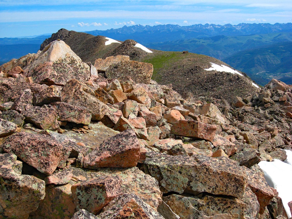
Once on the trail, it generally heads south, contouring along the east slope below Pt. 12,743 on the USGS map. At approximately these coordinates, the trail will begin to veer SW and gain elevation up a broad drainage to a saddle on the ridge south of Pt. 12,743. (N 39° 29' 10.71 W 106° 27' 04.78".) Head up to the saddle. If you lose the trail in this section, when you reach the saddle, look for it to be over on the west side of the ridge crest. From the saddle, follow the trail south to the summit of Notch Mountain over what will now mostly be frequent boulder rubble with interspersed tundra patches. As you near the summit, the boulder sizes will increase and there will be more broken rocks to slow progress, but nothing exceeds Class 2 work.
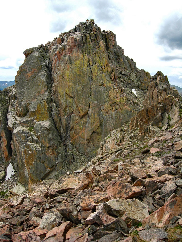
From the summit of Notch Mountain, hikers may still enjoy an impressive view of Mount of the Holy Cross. Descend as you came or, it is possible to continue south, passing through the "notch" and continue to the Notch Mountain Hut and also to UN 13,248. See our route description for UN 13,248 for advice on how to navigate the "notch," but you'll need to reverse the directions.
Additional BETA
Links to other information, routes & trip reports for this peak that may be helpful. -