LoJ: #59 (Pre-LiDAR #61) / 13,965' Pacific Peak

Peak Summary
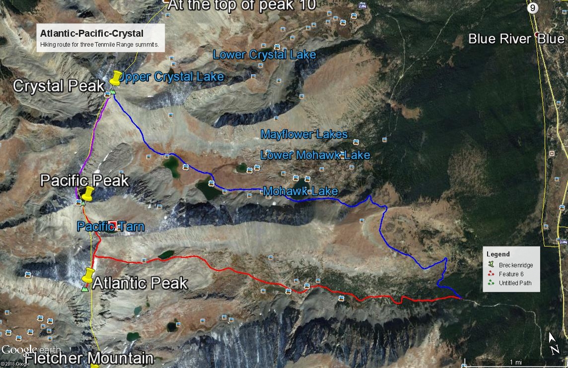
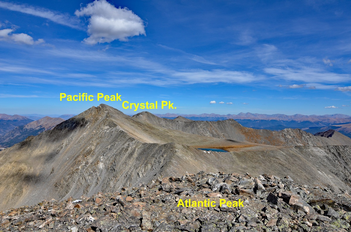
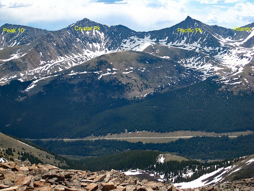
Pacific Peak is a Class 2 hike in the Tenmile Range SW of Breckenridge, CO. The McCullough Gulch Trailhead is our proposed primary route access point and can be reached by most passenger vehicles. The county road access to the gulch is the same as that used for the 14er, Quandary Peak, so weekend use in this area can be quite heavy, but those seeking the high 13ers will find much more solitude than the peakbagging hordes heading up Quandary. Pacific is sequenced with Atlantic and Crystal and our loop hike provides an opportunity to visit two beautiful drainages with high alpine lakes and abundant summer wildflowers.
Pacific Peak South Ridge Route
-
-
McCullough Gulch TH
The trailhead for McCullough Gulch uses the same directions as for Quandary Peak, initially. If coming from Breckenridge on SH 9, drive south from the center of town approximately 8 miles where you turn right (west) onto "Blue Lakes Road #850.
If coming from Hoosier Pass on SH 9, drive north from the summit of the pass just over 2 miles to the left turn (west) onto Blue Lakes Road #850.
NOTE: As of July 30, 2021, parking for either Quandary Peak or McCullough Gulch has been regulated. A parking permit must be obtained in advance at a significant cost, or you must ride a shuttle in from the airport north of Breckenridge to the trailhead. Check out this link for more info: https://www.parkquandary.com/ The shuttle will drop visitors off at the intersection described below. If you do not want to "pay-to-play" or utilize the shuttle, then an unregulated access can be found by using the Spruce Creek-Mohawk Lakes TH described on this site.Once on CR 850, drive past the large, day-use parking lot and make a right turn (north) onto CR 851. This is the same road that takes you to the well-used east ridge approach for Quandary. If arriving here on a summer weekend, drive past the multitude of cars parked along the road left by 14er baggers, and continue north, to NW for 1.7 mile to an intersection. The trailhead coordinates provided are for this intersection. If you can find a place to park, do so nearby to begin your hike. The road to this point is typically drivable by passenger vehicles. If no parking is readily available, take the left fork and you may be able to drive another .5 mile to a locked gate and a place where you can park at 11,090 ft. at these coordinates: N 39° 24' 03.99" W 106° 04' 45.23". Alternately, you can also take the right fork and drive down to the creek and park.
Camping
Overnight parking at any of the parking areas for Quandary is prohibited. Some at-large camping may be available in the area of the trailheads identified, especially down by McCullough Creek. But if arriving on a summer weekend, most any decent spot will likely be taken and these may now be prohibited as well. There are no National Forest campgrounds in the immediate vicinity. For campgrounds located near Dillon Res., try this site for more information: http://www.townofdillon.com/visit/camping-info.
-
From Atlantic Peak
Click thumbnail to view full-size photo + caption
Open This Route in a New WindowPlease Note: The McCullough Gulch TH access is now regulated and a parking permit is required, or a shuttle must be taken from the airpost north of Breckenridge to the trailhead, as of July 30, 2021. See the trailhead description for more information.
Atlantic Peak is sequenced with Pacific and Crystal. In this presentation, Atlantic serves as the first summit of a three-peak day that includes three, Top 100 summits, an uncommon combination for those attempting to climb the 100 highest. This circuit hike will take you across a wide variety of terrains. In earlier season, an ice axe can be handy. The Round-trip mileage shown for Atlantic is if you climbed Atlantic only and returned back down McCullough Gulch. Mileage and elevation gain are measured from the intersection mentioned in the trailhead description where we advise to park.From where CR 851 forks at our suggested parking location for this circuit, walk on up the left fork that heads NW, passing by a closed gate marking the end of vehicle progress. Continue on the old road. It will soon cross what Roach calls "Quandary Creek," (name not found on any map we have), on a very old bridge (hope it's still there), which in our estimation should perhaps be called McCullough Creek since it is found in McCullough Gulch. Once the road makes this crossing you can continue WNW on it for some distance until it switchbacks to the east. Depart the road and continue on a rocky trail, still on the north side of the creek. The trail then begins to gain elevation more steeply until it arrives at the east end of an unnamed, elongated lake at 11,920 ft. The old road/trail that leads up here is plotted out on the MapBuilder Topo version found on CalTopo. When you select our map on our website, you are taken by link to the CalTopo site so you have an interactive map to play with. On the right hand side, where it says "USGS 7.5" click on that and then you'll see something about "Base Layer." Select that and then of the various map versions available, select "MapBuilder Topo." This will show a well-plotted map against our roughly drawn red line.
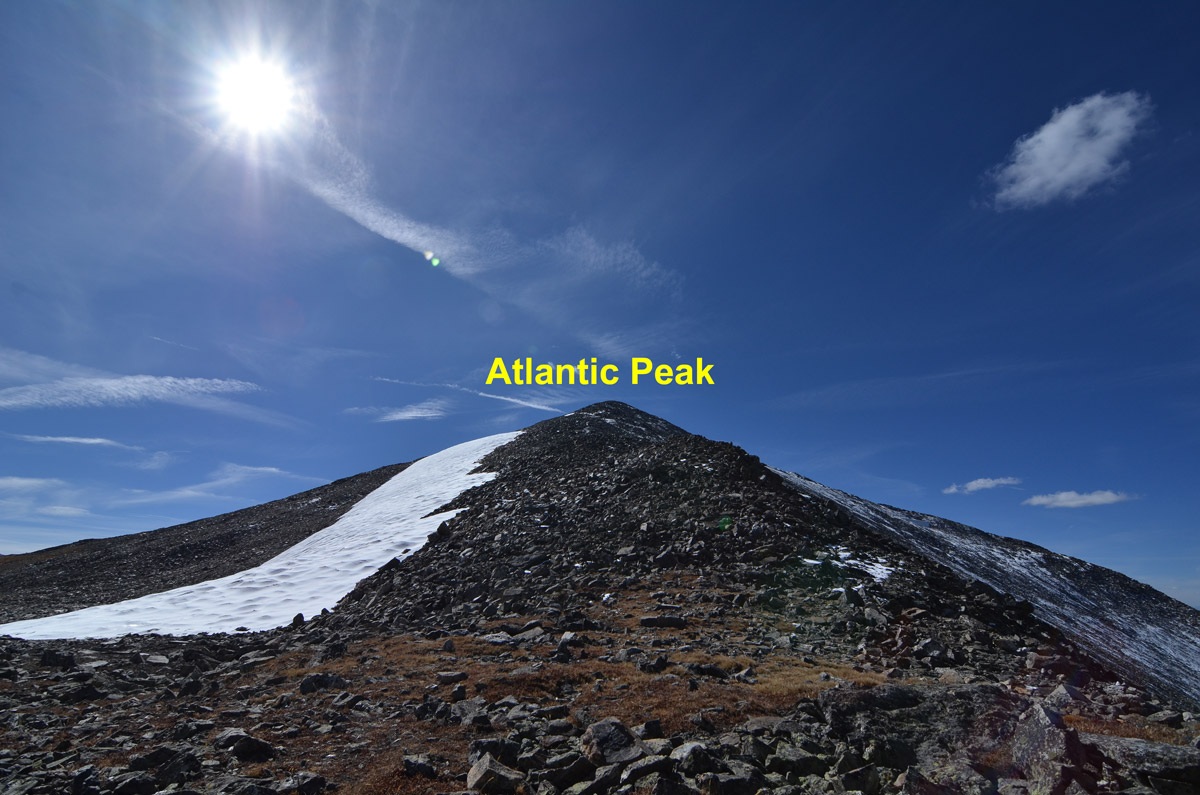
From the elongated lake, a trail continues on the north side to the west. At the west end of the lake, there are two branches of the creek that come together. Head up the more northern of the two drainages. Do not turn off on a trial that heads left that accesses a basin below Fletcher and Quandary. The goal now is to reach another smaller lake in a basin at 11,695 ft. shown on the map that sits below a rugged east-west running ridge in a rocky bowl. The trip from the lower lake to this upper one can still be accomplished on mostly tundra with nice solid rock outcrops along the way and open, low trees. This area is both verdant and scenic with nice wildflowers, but once you arrive at the upper lake/bowl, expect to find mostly talus & rubble. Some of the rock can be avoided by climbing earlier in the season. If you do, you'll likely find an ice axe handy in order to ascend west from the upper lake to the saddle between Atlantic and Pacific. There's a cliff band west of the lake that you'll need to find a route through, but if you choose the right, short gully that breaks through, you can still keep things at Class 2. Once atop the cliffs, there's more tundra coverage for a while as you advance to the Atlantic-Pacific saddle. From the saddle, turn south and follow the ridge crest to the Atlantic summit. The remainder of the route is on talus/rubble, or you may find the remnants of a snow - cornice patch that follows the ridge that you can walk on. Just be careful if you find it corniced.
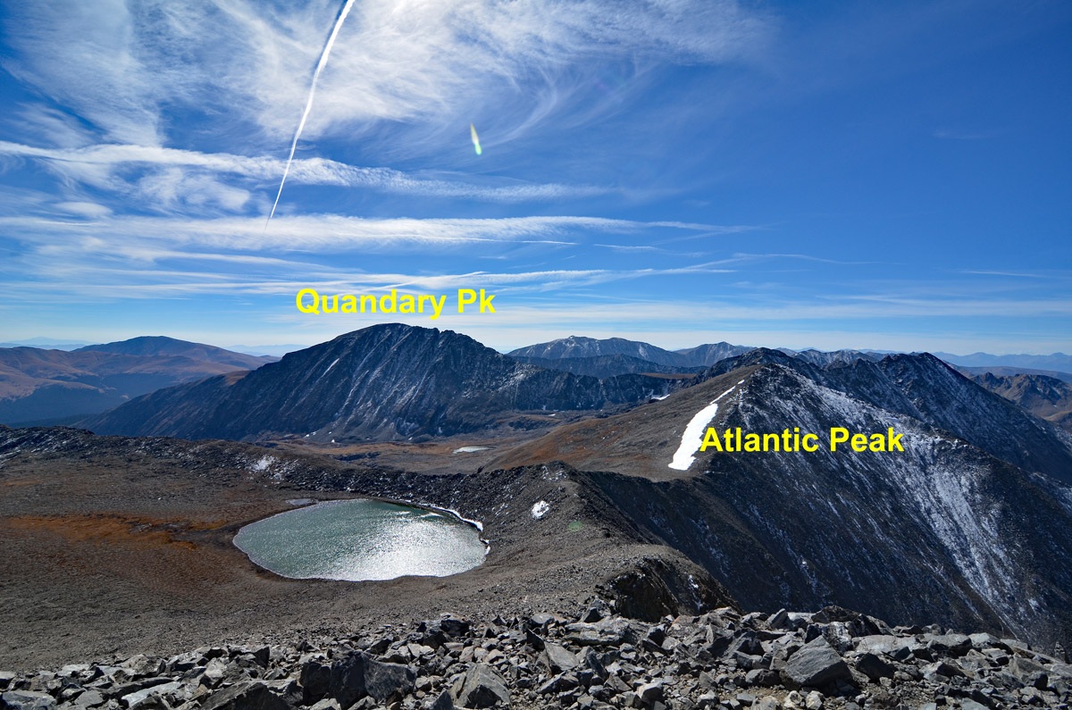
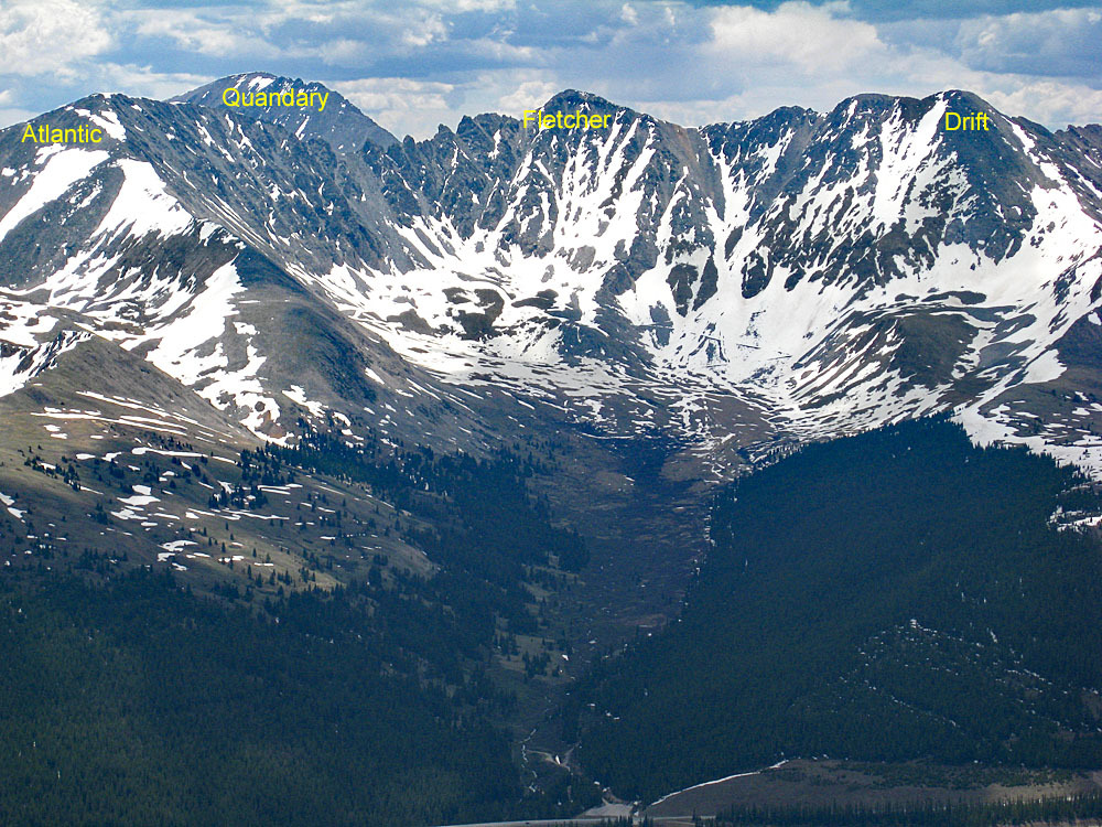
Perhaps the most impressive part of the view from the Atlantic summit is looking SE to the west ridge of Quandary that connects to Fletcher. It offers climbers a nice and challenging scrambling route to the Quandary summit. There are numerous sources to consult if you're enticed to try. For other route and approach ideas for Atlantic, Pacific or Crystal, see "Colorado's Thirteeners" by Gerry and Jennifer Roach.
Click thumbnail to view full-size photo + captionRoute Description
Year Climbed: 1988Please Note: The McCullough Gulch TH access is now regulated and a parking permit is required, or a shuttle must be taken from the airpost north of Breckenridge to the trailhead, as of July 30, 2021. See the trailhead description for more information.
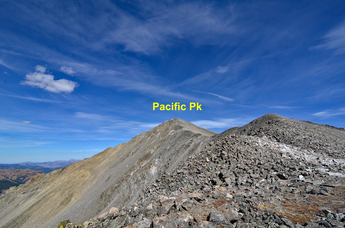
Pacific Peak is sequenced with Atlantic Peak and Crystal Peak for a longer, eleven mile, three-summit day. One way mileage and elevation gain are measured from the summit of Atlantic Peak. Round-trip mileage and elevation gain for Pacific assume completion of the entire circuit. Pacific Peak can be clearly seen from I-70 westbound as you emerge out of the canyon section just north of Copper Mountain. Looking a little east of south as you approach the turnoff for Copper Mountain, Pacific Peak presents a rugged, pyramidal shape and is quite impressive. On Google Earth, the highest elevation we could measure for Pacific was 13,858 ft., making it 92 feet shorter than the elevation provided on the USGS map. This is typical for GE to be off with a more sharply contoured, rocky summit and it may have an impact on the accuracy of our summit coordinates, which are not field verified.From the summit of Atlantic Peak, head back north, dropping down the ridge to the Atlantic-Pacific saddle. Begin ascending from the saddle, continuing north and passing over a ridge bump at 13,580 ft. Drop down, losing about 25 feet in elevation before resuming the ascent north while enjoying the view of the unnamed lake on the east side of the ridge. Because the elevation loss from the 13,580 point is so little, contouring around it is probably not worth the effort. The remainder of the hike to the Pacific summit will go easily, but over almost all basically stable rubble and talus.
For other route and approach ideas for Atlantic, Pacific or Crystal, see "Colorado's Thirteeners" by Gerry and Jennifer Roach.
Additional BETA
Links to other information, routes & trip reports for this peak that may be helpful. -