LoJ: #457 (Pre-LiDAR #464) / 13,234' S 7

Peak Summary
A moderately difficult traverse with some minor 3rd class scrambling on an unstable ridge. Combined with Mears and S.6, this could be part of a short backpack trip. May also be combined with S.8, S.9, and S.10 for the stout-hearted and strong. Lidar added 14 feet to the previous elevation of 13,220 ft.
S.7 East Ridge from Mears Route
-
-
Sheep Ck-Deep Ck Trailhead
From SH145 at "Society Junction," 4 miles west of Telluride, drive on 145 just a little east past the junction and turn left (north) onto "Airport Road." On Trails Illustrated #141, this road is labeled the "Last Dollar Road," #638. The Uncompahgre NF map labels it similarly. Follow the road uphill and around a sharp turn at the head of a drainage. The road continues west past the Aldasoro Ranch entrance. Bear right when the Airport Road turns off for the Telluride airport. Continue NW and in under a mile, park at the coordinates provided on the right in a trailhead parking lot with a small corral. The Uncompahgre NF map indicates that this is the beginning for trail #418.1B. There is some private property across from the trailhead parking.
Camping
As with all peaks in the Telluride area, camp sites are at a premium. Because of the private property close by, trying to car camp at the trailhead is not advisable and not allowed anyhow. The closest designated campgrounds are the "Town Park" on the east end of Telluride and the "Sunshine" CG south of Society Junction on SH145. (Good luck trying to find an open site.) For anything else, your best bets will be back west on SH145 near the Silver Pick Road turnoff (CR60M); and south on CR63L/J several miles past Illium.
-
From Sheep Ck-Deep Ck TH via Iron Mtn Trail Base Camp & Mears Peak:
-
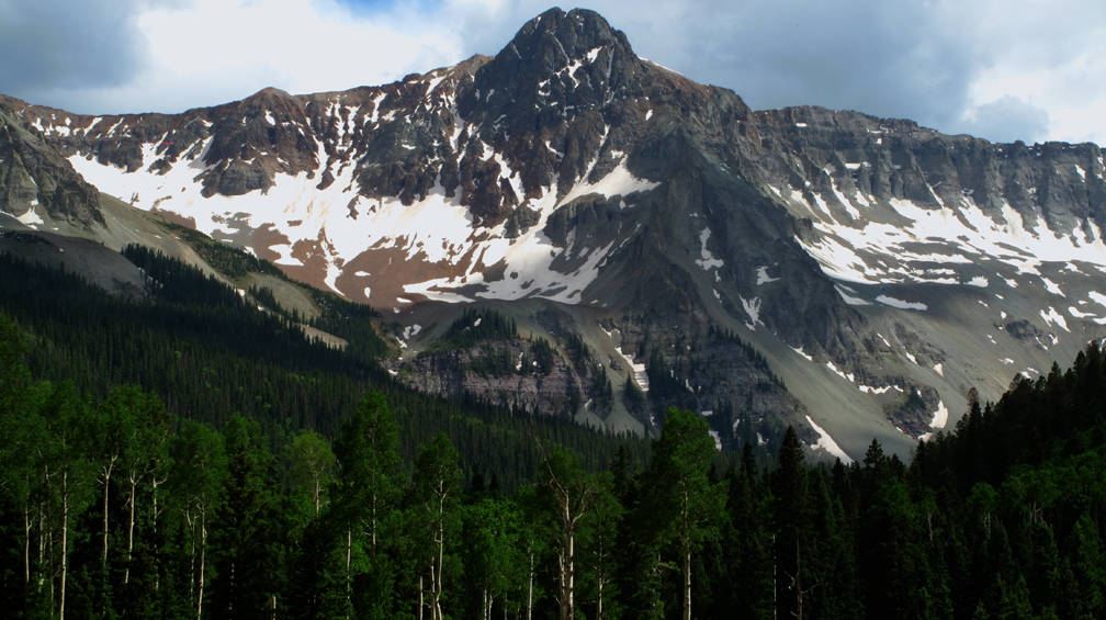
Mears Peak South Slopes Class 3 / 1 mi / 2,700’ One-Way
Click thumbnail to view full-size photo + caption
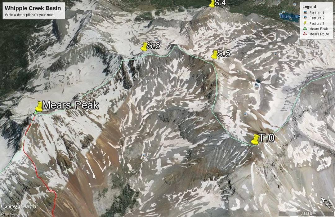
Open This Route in a New WindowMears Peak combines well with S.7 but not so well with S.6 because of technical problems along the connecting ridge. Mileage and elevation gain provided for Mears does not include continuing to either summit. See S.7 for details on the Mears to S.7 traverse along the connecting ridge.
From a campsite at 10,800 ft., or if you've walked in to do Mears as a day hike, look at the south facing slopes below and west of the summit. There will be several parallel tundra/grassy slopes separated by rubble-filled gullies. All of these slopes terminate higher up because of rocky outcrops and cliffs. Cross the creek and head up the slope farthest to the right. Gain as much elevation as you can on the tundra/grass. Eventually, the greenery will give way to small, rocky talus that slides away with each step. Once you leave the tundra/grass, you will be on broken rubble, scree, talus, etc., the remainder of the climb. Gain elevation until a cliff stops further progress, then angle east and north to avoid the cliffs and look for a break to continue on up. The footing will not improve. At times, the talus thinly covers sloping slabs of rock, making footing even more treacherous. As you continue to angle upward, you may find a small gully of solid rock that can be climbed with some 3rd class scrambling. Above it, you will emerge onto yet another talus-strewn slope. Hike in the direction of a small saddle west of the Mears summit. Once at the saddle, stand upright again, at least for a short time. If you go earlier in the summer, you may find some snow covering the talus. The angle is steep enough where you would probably want ice axe and crampons or at least, micro-spikes.
From the saddle, pick a route to the summit of Mears, still east of your location and another 500 vertical feet of gain. Be grateful for the somewhat better footing. When you reach the split summit, the view will help relieve the tension of the climb. To the north - the open lowlands of the western slope. Immediately around you, the contrasting rugged peaks. To descend, return as best you can by the same route. Be careful on the scree - this stuff, once it begins to slide, may not stop. If you haven't had enough already, continue west along the ridge to S.7, a 3rd class ridge traverse of well over a mile in length.
An interesting side note: The summit register we found on Mears recorded that Kent Beverly of Grand Junction had climbed Mears from its NE couloir, which he indicated he had attempted 5 times before succeeding.
-
Route Description
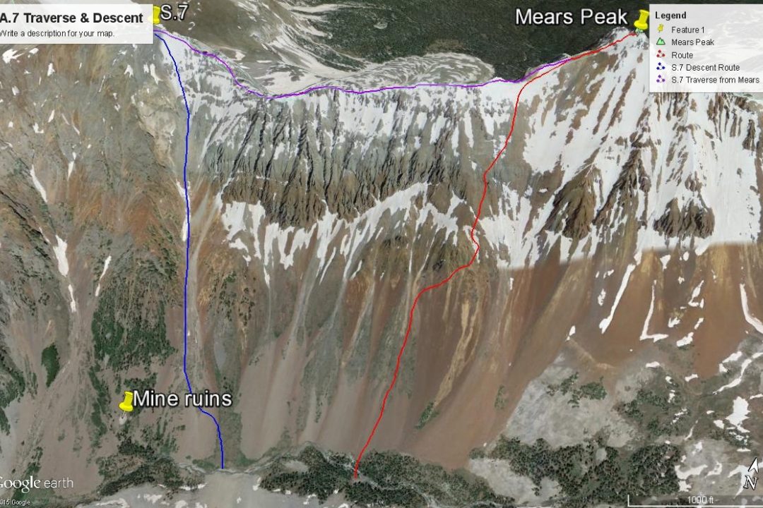
Year Climbed: 2002This route description begins from the summit of Mears Peak and follows the ridge that connects Mears to S.7 to the west. We completed these two peaks from a base camp in the Whipple Creek drainage, south of the Mears-S.7 ridge, starting from about 10,900 ft. Mileage and elevation gain are only for a Mears - S.7 and return to camp scenario. So it's only about 1 mile between the two summits and then another mile to descend back to the suggested campsite. Additional mileage is noted on the "Approach" to this area which may involve a short backpack, however, this could be completed as a day hike. Because we also wanted to include S.6, we made this a backpack trip.
From Mears Peak, begin hiking west along the connecting ridge. If you've used our suggested route for Mears, you'll be crossing back over familiar territory for a brief while. The first half of the traverse goes fairly quickly and easily. The problem comes in the middle section, just beyond the half way mark, and continues until the ridge begins to climb in earnest toward the S.7 summit. Wherever we could, we tried to stay on the ridge crest, but when forced off, it was always to the south side. The north side of the ridge always drops off precipitously. At some points, it will be difficult to ascertain whether to stay on the ridge crest or contour below on all the very loose rubble. Generally, contour as high as possible and regain the ridge crest whenever you can. There are short stretches of 3rd class scrambling and a couple of short "catwalk" sections.
Once you believe you are past all the major hazards, start hiking back up toward the ridge or follow the natural slope upward to the summit ridge for the finish. Pause on the summit to enjoy the view, re-gather your wits if needed and then survey the connecting ridge NW to S.8. If you have a campsite and gear back down in Whipple Creek, then you'll have to return to S.7 to get back to your gear.
To descend, go back from the summit along the ridge eastward a short distance and then turn down a large and prominent couloir that tumbles down 2,000 feet back to the valley floor. It empties out just east of the old mine ruins and west of the good campsite area. The couloir is highly visible from the campsite. It does have some small scree for easier and swift descending in short sections, but is mostly filled with medium to small rubble that will slow descent until you're almost sick of it.
Additional Note: If you've already completed Mears and S.6 some time in the past, but have not done S.7, S.8, S.9 or S.10, it may be possible to do all four of these as a day trip from the same trailhead for Mears and S.6 we have described. From that trailhead, you would need to hike to the old mine up Whipple Creek and ascend S.7 using the descent couloir we describe. From the summit of S.7, you could continue NW to S.8 and follow connecting ridges all the way around to S.10 (UN13,020). From S.10 you could drop south into the headwaters of Deep Creek and follow out the drainage to pick up trail #418 that will led you back to your start point.
-