LoJ: #308 (Pre-LiDAR #332) / 13,420' South Lookout Peak

Peak Summary
A mountain with a foreboding reputation, or as one climber we met put it, "it gives off bad vibes," South Lookout Peak is an easy stroll followed by a short but difficult summit finish that goes at Class 4 by our suggested route. 4WD will make accessing this peak shorter and easier by way of Clear Lake. Helmets very useful. Rope & protection may be needed depending on the experience level of your group. Lidar evaluation has added 40 feet of elevation to South Lookout, boosting its rank to 308, formerly 332.
South Lookout East Face Route
-
-
South Mineral CK. - Clear Lake TH
Use this trailhead description for climbing S. Lookout Peak; V.5 or possibly V. 2 as an alternate route.
From the Town of Silverton and the US 550 intersection on the west side of town, drive north on US 550 and in a little over 2 miles turn west onto FR585. If coming from Ouray, drive south on US 550 over Red Mountain Pass and watch for the FR585 turnoff on your right before reaching Silverton. Drive west on this graded dirt road to the campground and trailhead parking appx. 4.7 miles in. The last mile of road gets a little rougher but should still be navigable by passenger cars.
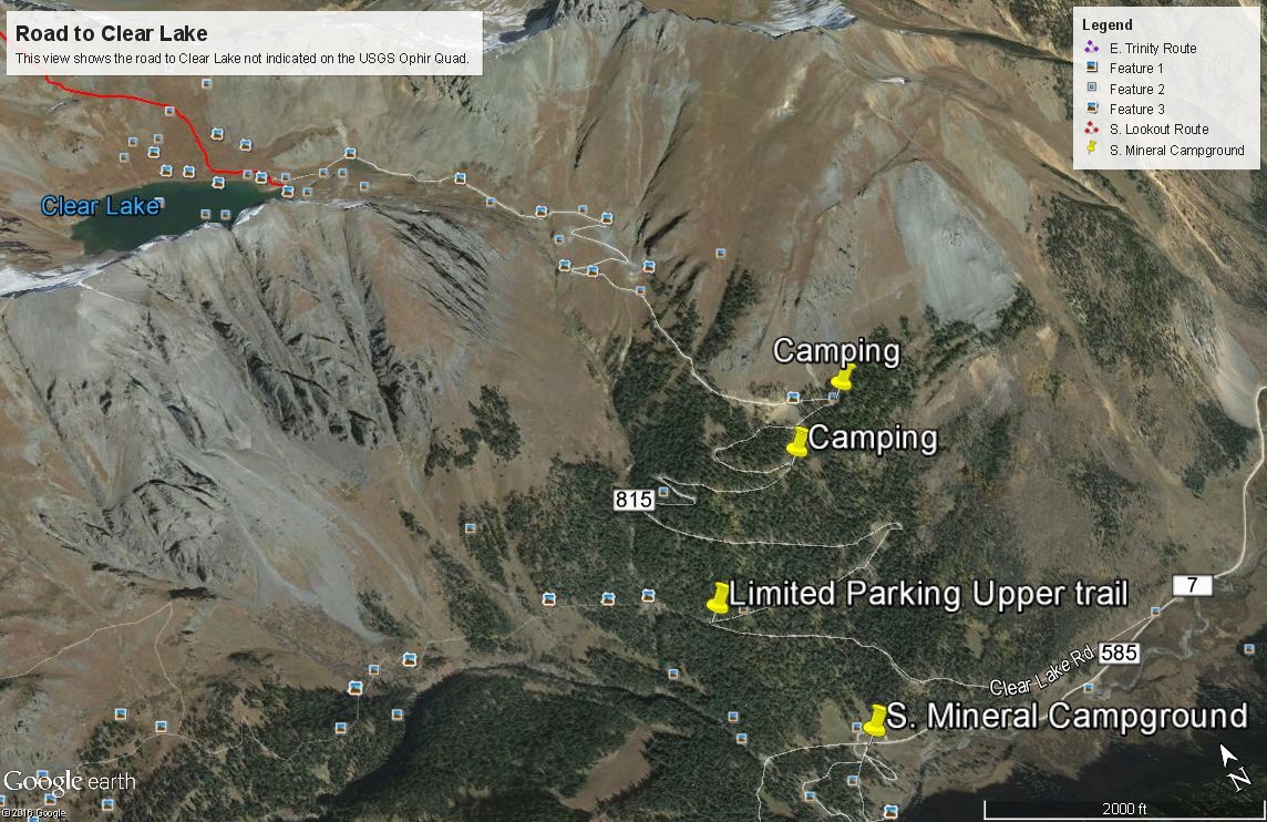
To reach Clear Lake and the Clear Lake FR815, at 4.2 miles in on FR585 after turning off US550, there's a single-track road that veers off to the right at these coordinates: N 37° 48' 19.42" W 107° 46' 25.33". Elevation is 9,795 ft. The road is best suited for 4WD with good clearance. This is known as the "Clear Lake Road" and actually continues all the way to Clear Lake. The road does not show on the USGS 1955 quad. The road has a lot of switchbacks. On the lower section, there are eight. #7 is not so much a switchback as it is a broader turn that still mostly reverses direction. Above these 8, when you break out of the forest, there are four more to gain the final elevation needed to reach Clear Lake. There is limited camping at switchbacks #6,7 & 8. Otherwise, go all the way to the lake at elevation 11,985 in the parking lot for a more frigid overnight stay.
Camping
All along FR585, once you turn off US550, there are numerous at-large, primitive sites. Upon turning off US 550 and driving less than a mile, there's a large open area on the left with a vault toilet. There are usually a large number of RV's here. There is also the South Mineral Creek Campground and before arriving at the campground, you will see a number of other camp spots. Expect fierce competition on summer weekends for sites. This is a very popular area. There is no "allowed" camping at the trail head parking area.Directions for South Mineral CG per San Juan NF: South Mineral Campground is accessed by turning off U.S. Highway 550, about 3 miles west of Silverton, onto Forest Rd. 585, which heads west along South Mineral Creek. The campground is 4 miles off the highway and has 26 mostly level sites. Several camping loops and well-spaced sites are mostly shaded, but some are sunny. A few are next to the creek, and some have large parking areas. The Ice Lake Basin Trail, a strenuous, steep, and popular hike, begins across the road from the campground. It leads up above timberline to high alpine lakes surrounded by meadows of wildflowers and rocky peaks. South Mineral Campground does not take reservations. All sites are first come first served. There are an assortment of designated areas along South Mineral Road where dispersed camping is allowed so there is plenty of camping in the canyon on all but the busiest days.Picnic tables, composting vault toilets, fire grates, trash disposal, potable water. No electricity. Operated by concessionaire. The campground has 26 sites that are mostly level, at 9,800 feet. Some sites are handicapped accessible. Several camping loops and well-spaced sites offer plenty of privacy. Spruce and fir give lots of shade, but there are some sunny sites. A few sites are along the creek, and some have large parking areas.Dispersed camping along Forest Rd. 585 is allowed only in designated camping areas. Please follow posted directions and instructions.
Campsite Locations
South Mineral › N 37° 48' 23.52', W 107° 46' 25.33"Elevation 9,855 ft.
-
From South Mineral Creek South Fork TH via Clear Lake
The approach for South Lookout, V.5 and possibly V.2 involves driving up the Clear Lake Road to Clear Lake. The turnoff for this road is provided in the trailhead directions with GPS coordinates. It's about 3.9 - to 4.0 miles in from the turnoff for the South Mineral Campground from US 550 and turns off to the right if heading west. Drive up the road for .9 mile to a switchback. There's room for a few vehicles to park here for access to the "upper" trail into Ice Lake Basin. For Clear Lake, continue driving up the road. For the most part, the road is in good condition. Most any stock 4WD should be able to handle it and some lower-slung all-wheel drive vehicles may also be able to navigate. There's a total of 8 switchbacks in the trees. At the last two, there are some camping possibilities, but weekends may find even these taken. Higher up, above tree line, there are 4 more switchbacks to gain the basin at lake level. There's some parking at the lake and another parking area at the mouth of the basin and just west of V.5. Driving the road may take a half hour or longer depending on how much you want to beat up your shocks.
Camping
There are some camping possibilities on the last two switchbacks along the road while still in the trees. There is also some room to camp at the lake, but no trees.
Open This Approach in a New Window
Click thumbnail to view full-size photo + captionRoute Description
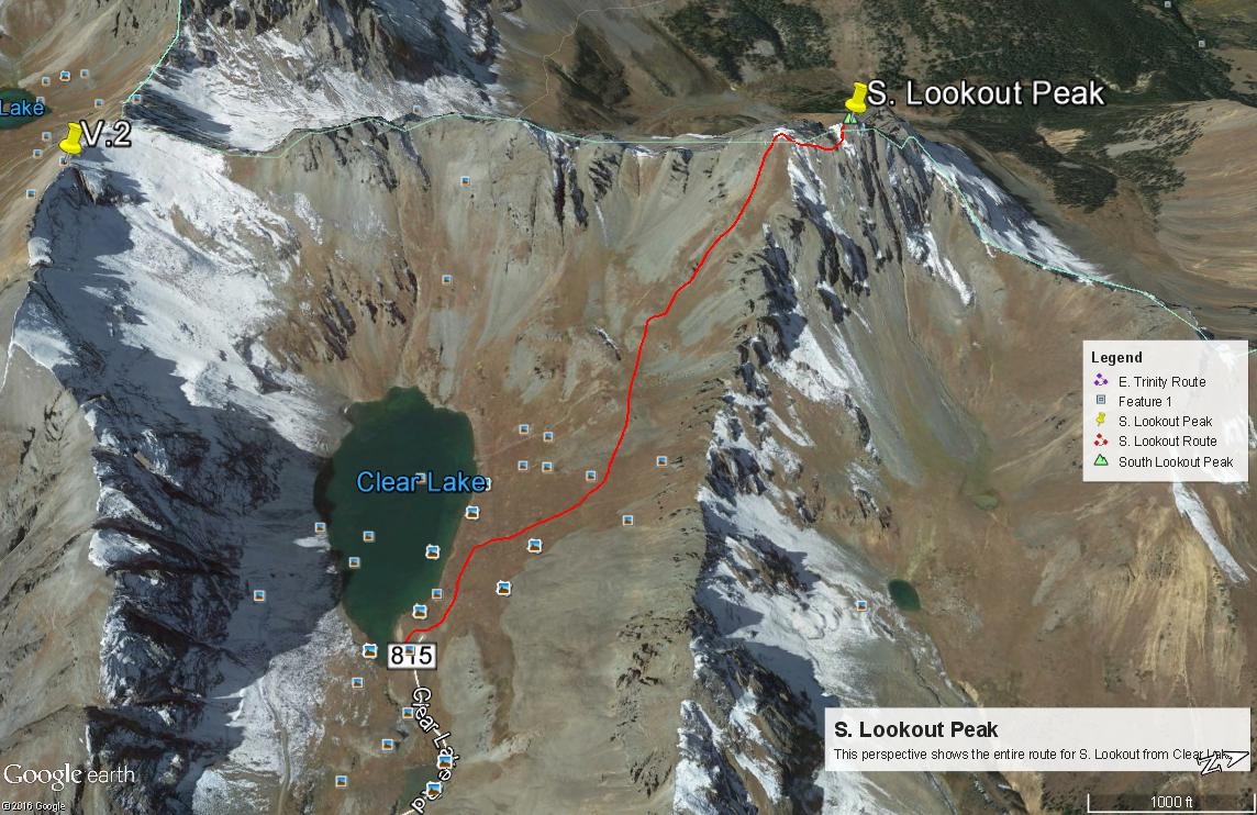
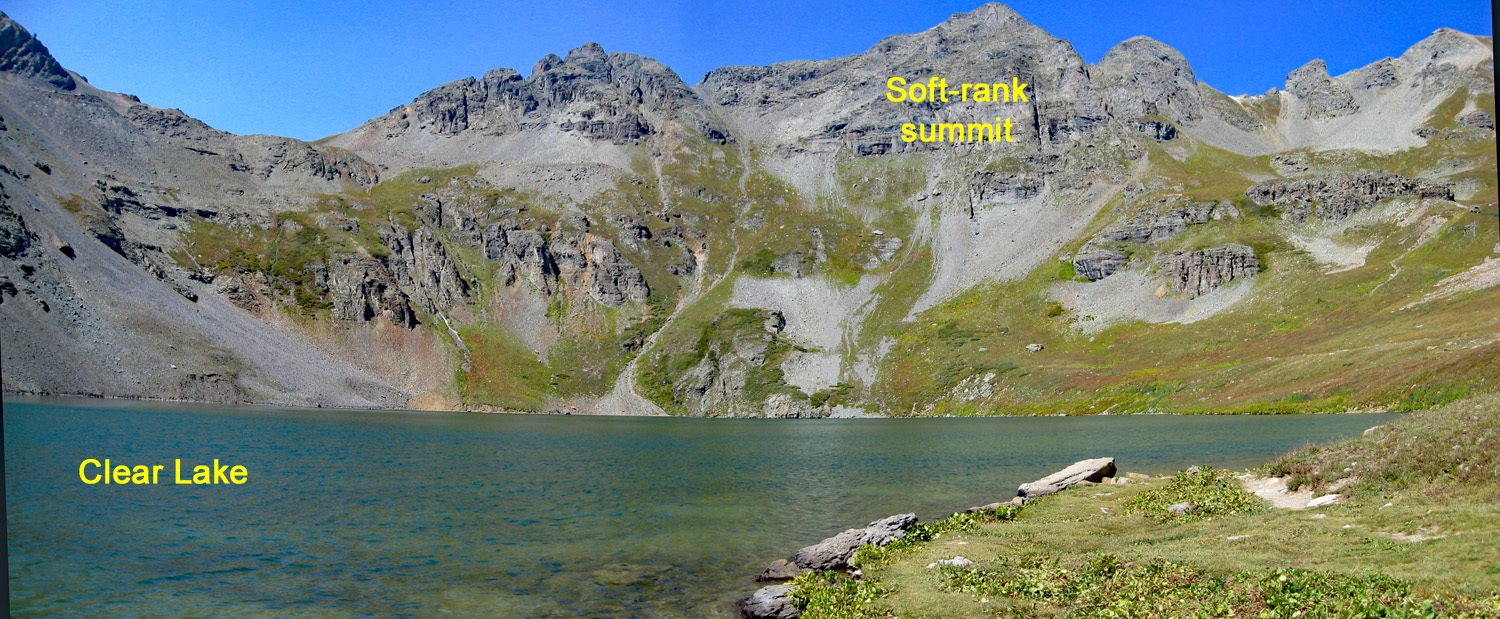
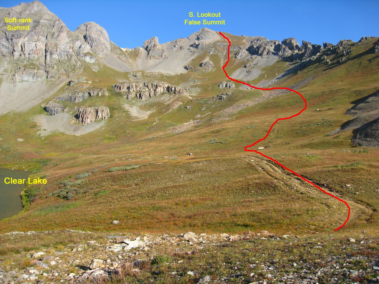
Year Climbed: 2007From wherever you choose to park in the vicinity of Clear Lake, walk on up to the lake and then follow a trail around the east end that heads up toward the saddle on the long connecting ridge between V.5 and South Lookout. There is a rocky summit west of the lake that is mistaken by some to be South Lookout. It is not. It is a "soft-rank" summit however and a worthy climb if you have the time. The true summit of South Lookout is NW of the lake and not actually visible from the lake or on your way up.
After you have followed the trail to the saddle up for some distance, begin to veer away to the NW and hike up through lush displays of wildflowers toward the false, south summit of S. Lookout. The hike all the way up will be mostly on grass & tundra, with some soft scree as you near the false summit. It will take most of an hour to reach the false summit, which is unnecessary to go over. The easy strolling is now over. The survey map gives no indication of what lies ahead.
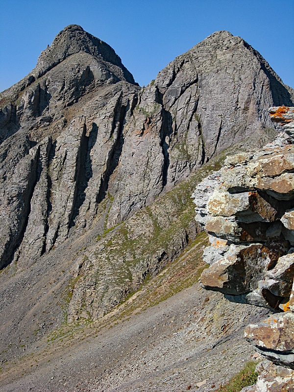
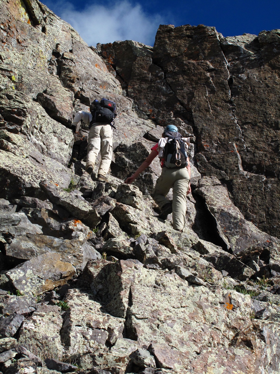
The true summit of South Lookout, when examining the USGS quad, is the middle of three high points. The north point shows an elevation of 13,357 ft., but this is not the highest point, which is found on the middle summit. In attempting this peak, we had a few sources of beta. I believe the route we took was not described on any of that other beta. The others seemed to have you contour farther along the east face of the peak than what we did. I believe our route provides a shorter, but not necessarily any easier approach to the summit. The climbing required is not difficult, so we rate it at 4th class, but loose rock and some exposure may make this seem as 5th class.
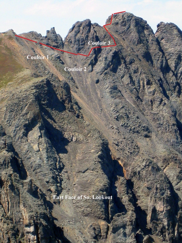
If one proceeds directly north along the ridge crest, from the false, south summit, you will not get far before being confronted with a vertical wall of rock. There is no apparent way to circumvent this wall on the west side. All the information we had indicated the way to the summit was on the east side, and we could see why this was the prevailing opinion.
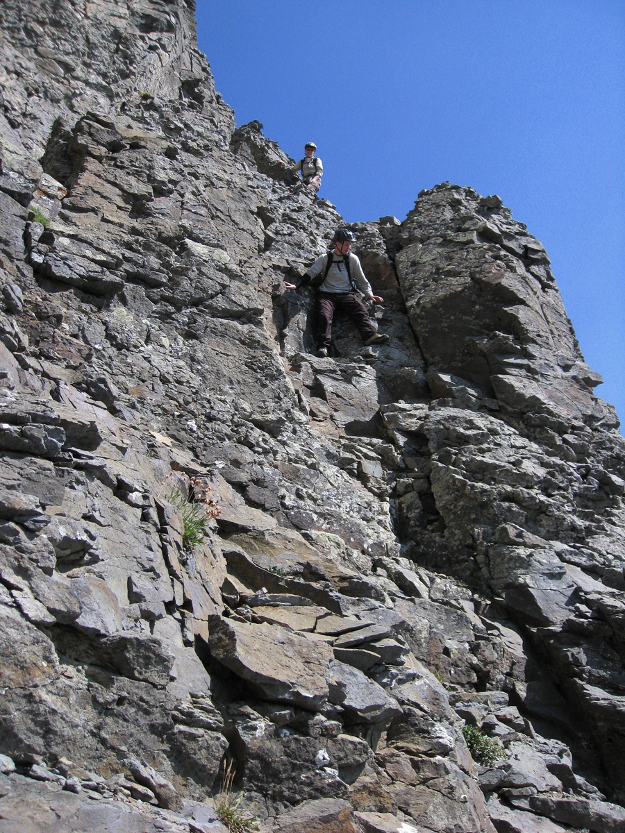
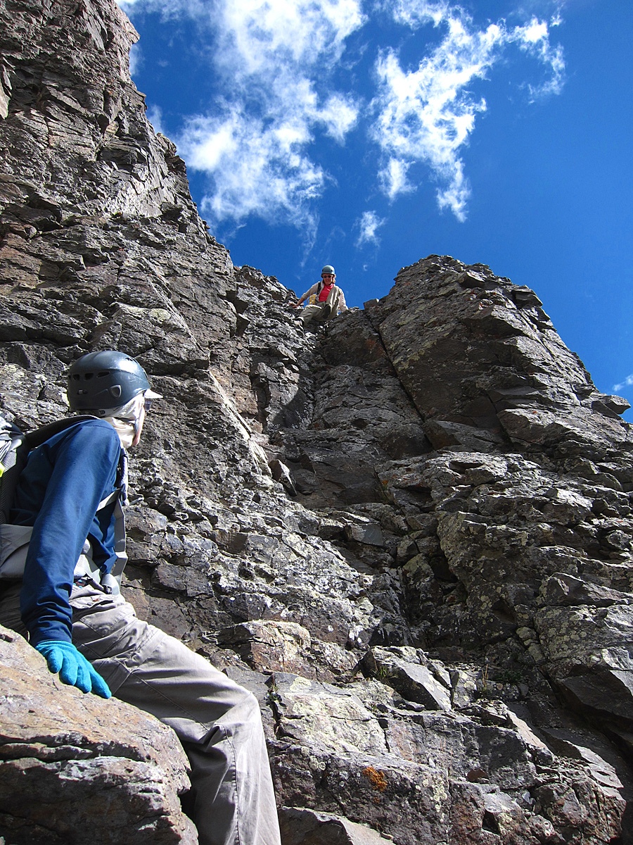
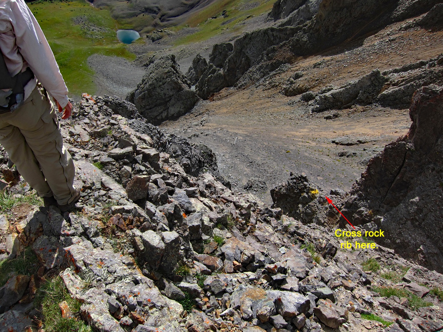
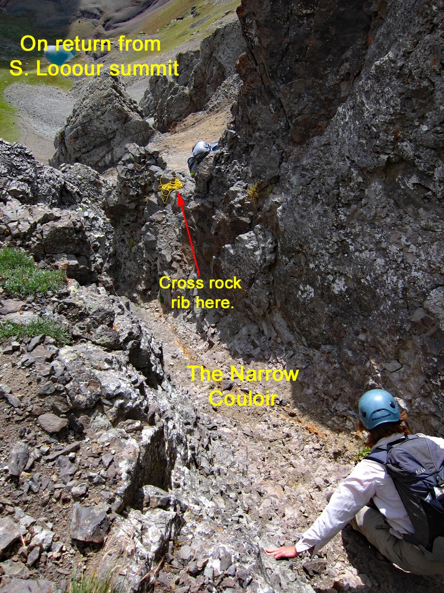
Our plan then, was to follow the sketchy directions we had from a couple of sources.From the east side and below the false summit, we began by hiking at a descending/contouring angle down the east flank of the mountain, crossing one branch of a larger, scree-filled couloir, then a very minor rib of rock and entering the second branch of the wide couloir. We continued angling down and arrived at a vertical wall of rock that halted further progress north. Total elevation loss to this point was less than 100 ft. and one could have easily scrambled directly up and have been back on the south ridge. At the wall of rock that confronted us, we continued to descend some until we came to a place in the wall that was not so vertical and appeared to offer a scrambling access to whatever lay above. Ascend on up the receding rock layers above at this breach in the wall. A 4th class scramble of about 30 vertical feet will bring you to a small perch where you can change direction toward the left and cross over the crest of the rib. If using a rope, there are a couple of spots where you can belay others up here. On the rib crest, peer into an extremely steep gully just a few feet away. A rock ledge, about 4” wide and 3 feet long leads into this narrow gully. Enter the couloir. It is so narrow, you can stretch out your arms or feet and touch both sides. It was almost like a near vertical slot canyon. Earlier in the season, it would most likely be filled with snow and require the security of an ice axe to cross. Exit the couloir at almost the same level at which you enter, scrambling up only a few feet to find a good exit point. Walk out onto the more stable and secure slope above the couloir and perhaps find a faint trail. There may even be a cairn. Hike NW along the slope of rock ledges and tundra, cross the next minor ridge and then ascend west in yet another flat scree-like slope to a flat area immediately below the middle summit block. From here, it's just another easy, 3rd class scramble through a minor cliff to the summit on secure rock. We did not use rope on this ascent, however, in returning to this same route in 2013, we did use rope, in part for the sake of another party member who was not at ease with the exposed scrambling, but also because it just felt better to have it on the many loosely perched rocks you have to scramble over. If taking rope, you don't need more than 100 feet and some sling to set up an anchor.
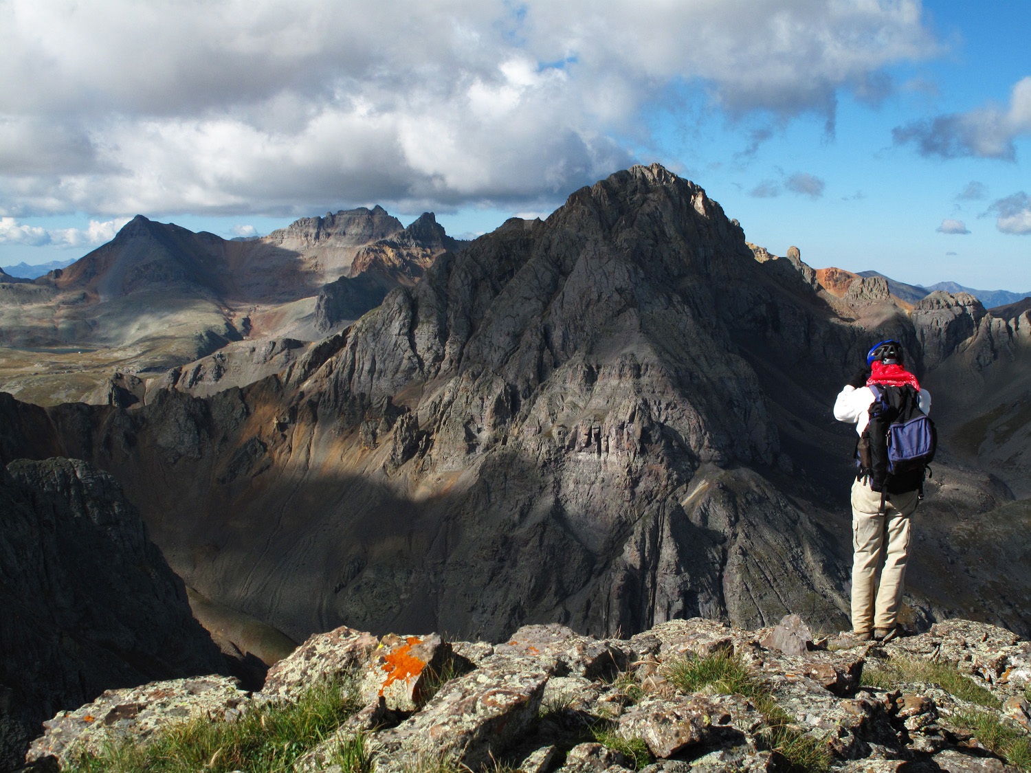
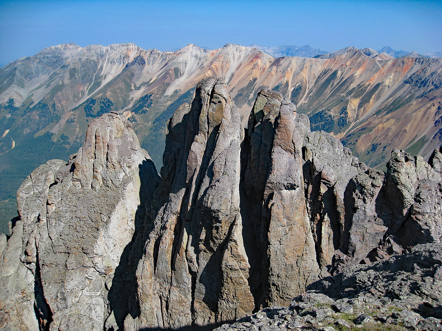
From the summit, you have an impressive view north of the long east-west running ridge of Silver Mountain, San Joaquin Ridge, etc. To the west, US Grant offers an imposing east face. And then to the SW, the summits around Ice Lake Basin are visible. The views are quite impressive. To return, going back exactly as you came is the safest bet. If you have time, consider tagging the soft-ranked summit west of Clear Lake. It makes another interesting climb without the fear factor of South Lookout.
Additional BETA
Links to other information, routes & trip reports for this peak that may be helpful. -