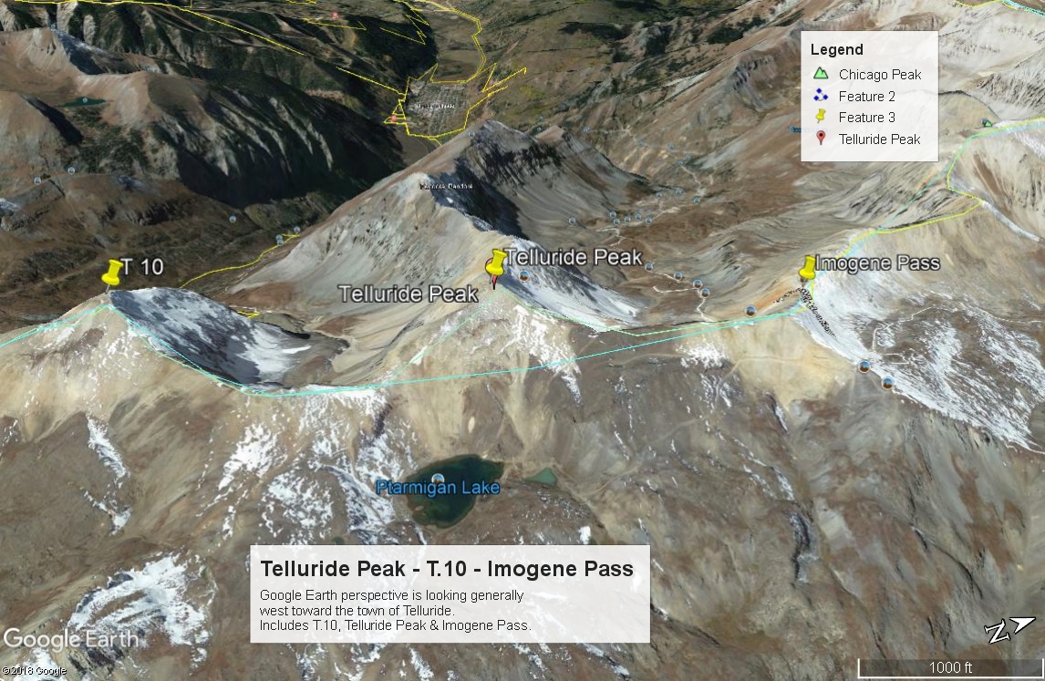
LoJ: #385 (Pre-LiDAR #379) / 13,315' T 8

Peak Summary
T.8 is sequenced with Telluride Peak (now ranked) and T.7. From T.7, T.8 is a Class 2 - 3 ridge traverse if the saddle section is avoiding by dropping down on the north side of the ridge. Remaining on the ridge crest will lead to Class 3 - 4 work because of some rock towers that block the way. Once past the saddle obstacles, the summit is easily obtainable. The trailhead for this sequence of peaks is the paved parking area on US550 , north of Red Mountain Pass, overlooking the Idarado Mine. The route we suggest goes up Commodore Gulch for a short distance, then follows a stream course that is a tributary to the main stream in Commodore Gulch. The hike offers a chance to view both deer and elk. Pre-Lidar elevation was 13,317.ft.
T.8 Southwest Ridge Route
-
-
Idarado Mine - Red Mtn. Pass TH
To reach the parking for the Idarado Mine viewing area, drive south on US550 out of Ouray for approximately 12 miles to a turnoff on the right that leads to a large parking circle that overlooks the Idarado Mine complex, most of which is on the south side of the highway. This is just before a very tight switchback. If coming from Durango/Silverton, drive north on US550 to the summit of Red Mountain Pass. Continue from the pass to the north and drop down just under 2 miles to the same turnoff that leads to the parking area, which will be just after the same tight switchback. The parking area is passenger car accessible. There are no facilities there.
Previously we advised that you could walk down through the old, somewhat preserved structures just west of the parking area to begin the hike. These are known as the "Idarado Houses" and have historic value. A two-year preservation and restoration project is presently underway (as of 2022) and the area is cordoned off. To begin your hike, either park on the switchback just above the viewing area (there's room for a few vehicles there) and walk NW avoiding the gated area off to the left to begin your hike., or park in the viewing area and walk up to the switchback curve along the highway to start.
Camping
The nearest camping areas are back north in the vicinity of Ironton and Ironton Park. There are primitive sites a short distance up the road for Corkscrew Gulch. There are plenty more primitive sites on the south side of US550 just south of the turnoff for Corckscrew Gulch. A few primitive sites can be found in the vicinity of Red Mountain Pass and up the Black Bear Pass road.
-
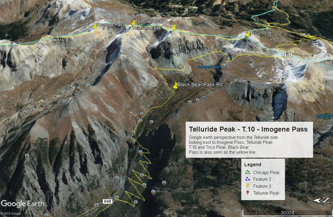
From Telluride Peak T 7
-
Telluride Pk via Commodore Gulch Class 2 / 2.8 mi / 2,860’ One-Way
Click thumbnail to view full-size photo + caption
Open This Route in a New WindowFrom the trailhead parking area, you want to locate an old road labelled as FS895. The actual access from US550 has been gated, closed and posted for many years now. So, from the parking area for the Idarado Mine, walk downhill a short distance initially, heading NW a briefly toward some old structures that were once support buildings to the mine and then from the northernmost structure head more west and hike uphill a little to intercept the old road. Hike generally NW along the road until you come to the creek in Commodore Gulch. Not wanting to have to find a way across in the early morning, we turned west and began following the stream course on the south bank hiking up through trees, gaining almost 400 feet in elevation. There will be another branch stream coming in from the left (SW) which is easier to cross. Do so and continue walking uphill following above the stream as it turns from a SW direction to northwest and comes to a small pond/lake at just above 12,480 ft. At about 11,700 ft., there's a nice bench area. In that vicinity you may pick up an old trail that leads up to the small lake, however, this entire area tends to be laced with game trails anyhow through all the lush tundra.
From the small lake at 12,480 ft., follow the old trail NW up to Ptarmigan Lake, which does not come into view for some time. In fact, you don't really see the lake until you get above it. Around the lake and the smaller upper pond, there are old mining roads. From the low pass just south of the lake, hike west over gentle terrain and then contour NW to the south ridge of Telluride Peak. One of the old mining roads leads up in that direction. On our way up, we encountered several patches of snow at the very end of June. The remainder of the hike along the ridge is uneventful on tundra, embedded rock, scree & rubble. The most redeeming part of the ridge will be the fairly spectacular views off towards Telluride and the Black Bear Pass Road. This soft-rank summit is sequenced with T.7 and T.8 so if up to it, continue the hike on over too these two ranked summits.
-
T.7 Southwest Ridge Class 2 / 1.3 mi / 645’ One-Way
Open This Route in a New WindowT.7 is sequenced with Telluride Peak, followed by T.8. One-way mileage and elevation gain are measured from the summit of Telluride Peak. Round-trip mileage and elevation gain assumes completion of the full sequence.
From the summit of Telluride Peak, walk north along the ridge to the 13,365 point just south of the Imogene Pass summit, then walk down and east to a saddle at 12,860 ft. before continuing up 500 vertical feet to the summit of T.7. This was all on easy tundra with just a little rock - scree & chiprock. The summit of T.7 is broad and flat. It offers a good place to sit, refuel a little and enjoy a spectacular view gazing off toward Telluride or back down into the Red Mountain Pass area, US550 and Ironton Park.
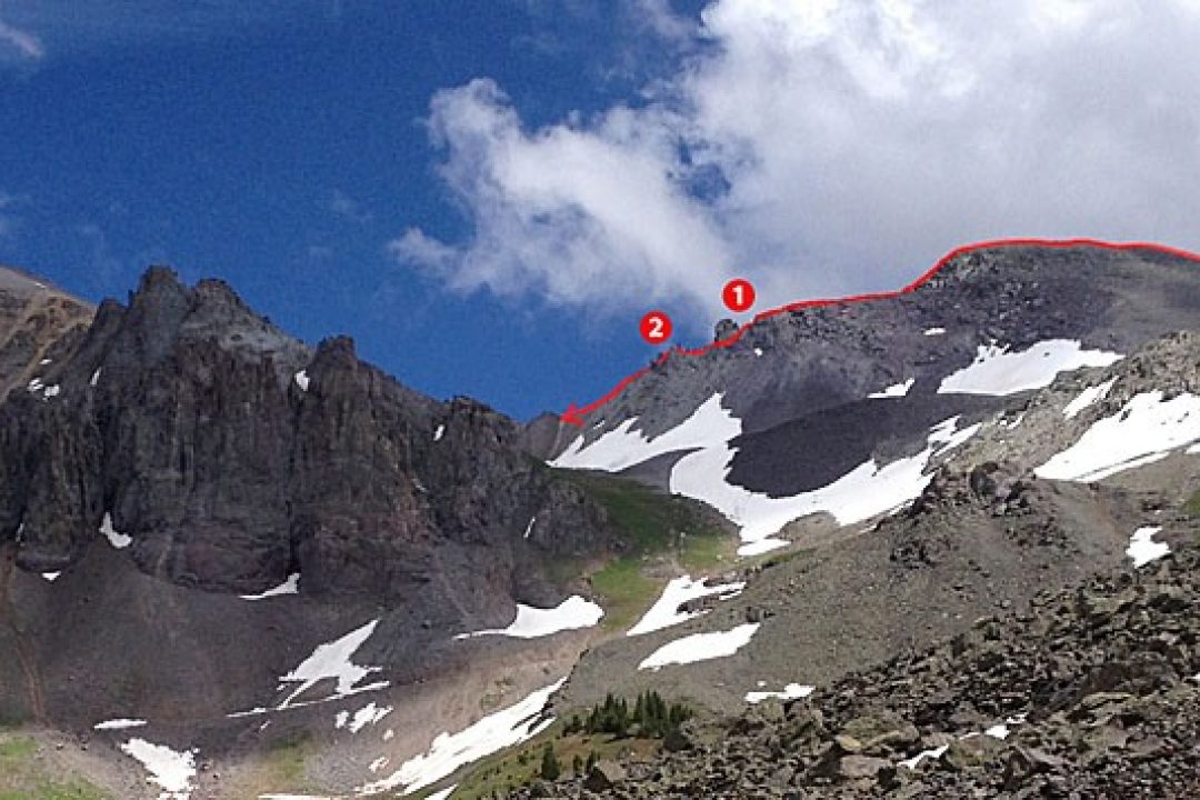
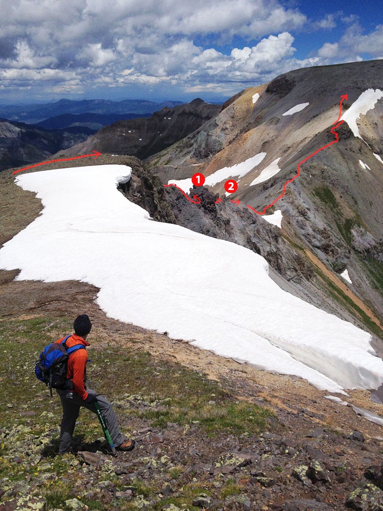
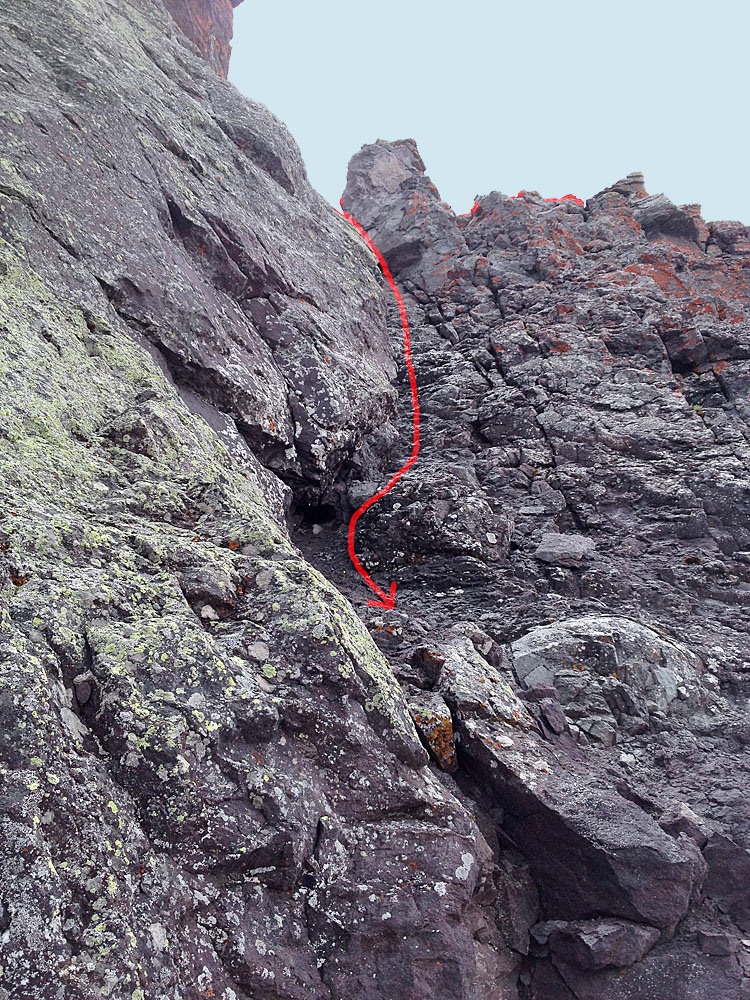
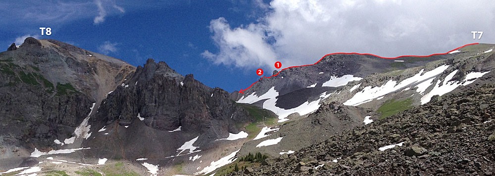
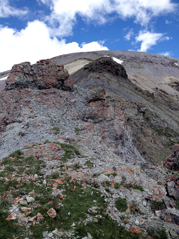
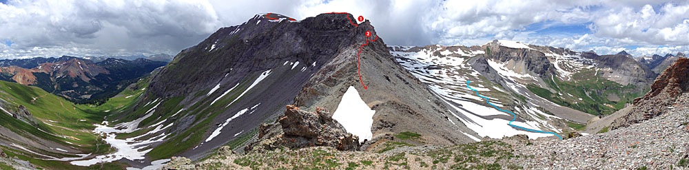
The traverse from T.7 to T.8 involves a tricky section of ridge near the connecting saddle. If planning on continuing on to T.8, consult the photos posted for T.8 to obtain a better idea of the ridge obstacles and how best to get around them. Those photos are supplied by Shaun Cooney and his wife Lyndsi and are more recent.
-
Click thumbnail to view full-size photo + captionRoute Description
Year Climbed: 2001T.8 is sequenced with Telluride Peak and T.7. One-way mileage and elevation gain are measured from the summit of T.7. Round-trip mileage and elevation gain assume completion of the sequence.
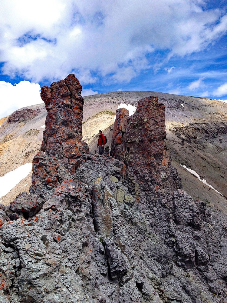
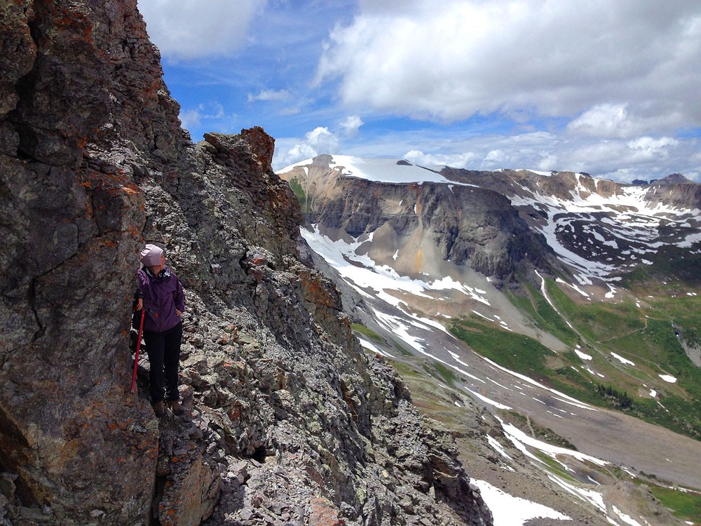
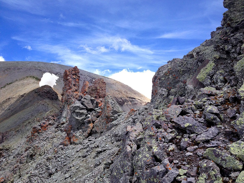
From the summit of T.7, follow the ridge north. It starts out easy on relatively flat rock but then steepens as it comes to the T.7 - T.8 saddle. Less than 100, maybe only 50 yards from the saddle, the ridge turns to rock pinnacles/towers. Further progress is blocked unless you want to take on some 3rd class work with some moderate exposure. We chose the more cowardly option of dropping off the ridge to the northwest side and worked our way down carefully on a lot of loose rock until we felt we could contour northeast across a couple of ribs and gullies. We probably lost at least 100 vertical feet if not 150. We then scrambled up another gully back to the ridge and came out just beyond the pinnacles. At the most, this was 3rd class scrambling. If you drop even further down in elevation as some report, you can avoid even these problems and keep things at Class 2.
The remainder of the hike is fairly steep, over some loose rock, but is reasonably stable, so in short order, you should arrive at the summit of T.8. While signing a summit register, we found accounts from Jennifer Sears-Roach and one other climber who had successfully negotiated the ridge through the saddle.
The summit of T.8 is also broad and flat and pleasant and we enjoyed it for as long as we could, but the afternoon buildup was growing quickly, so we had to head on down or expose ourselves to the inevitable lightning. To descend, hike along the summit to the southeast and then turn down to the south in a broad gully. We had to cross a small, corniced snow field, then were able to rapidly descend on a lot of scree for quite a distance. As we descended, the scree gave way to larger rocks and then tundra. By the time we reached the old jeep track above the creek, the tundra was lush and you could tell that in a few more weeks, this place would be rife with wildflowers. With the imminent threat of rain, we scurried on down the road to the first switchback where we put on our rain gear. The little creek crossing after here was no problem and we continued hiking in ever increasing rain, back down the road.
The road took us by the Barstow Mine. It appeared this area was still being utilized in some way and we might be perceived as trespassing, so we hastened on. At the main creek in Commodore Gulch, we chose the old, “go-for-it” approach to creek crossings. That is, you pick a route across that seems to follow the most shallow path, and with boots on, you leap through as quickly as possible, hoping that you won’t give that water enough time to invade your boots if you keep moving. It worked! But with all the rain for the last half hour, it wasn’t saving us much from getting wet. In another 15 or 20 minutes, we were back at the parking area trailhead. Total hiking time was around seven hours.
Several years later, our son and daughter-in-law also did the T.7 - T.8 traverse and stayed on the ridge. The series of photos provided here will give hikers some idea of how to navigate the difficulties there. Be sure and view them.
Additional BETA
Links to other information, routes & trip reports for this peak that may be helpful. -