#485 / 13,208' Tuttle Mountain
Peak Summary
With a vehicle that has better ground clearance (like some cross-over types, etc.,) Tuttle Mountain can be a quick and easy Class 2 hike on mostly tundra/grass and pairs nicely with Houghton Mountain, a short distance east by connecting ridge. Lidar added 5 feet of elevation.
Tuttle Mtn. - South Face Route
-
-
California - Placer Gulch TH
From the Town of Silverton, drive east on the main road through town to where the paved road splits one block past the courthouse and veer right onto the blue-signed County Road 2 (set odometer here) for 4.2 miles of nicely graded dirt road to Howardsville. (On Trails Illustrated map #141, this road is labeled #110. Pavement ends after 2 miles. This road is also known as "The Alpine Loop Road and BLM 4500.) From the Howardsville intersection, continue north another 4.3 miles to the old site of Eureka. The road will cross to the west side of the Animas River and continue up a steeper shelf section. The road begins to get a little more difficult and enters a more narrow section of the Animas River canyon. At about 10,740 ft., the valley begins to widen out again. In that location, another road heads off to the left for Picayne Gulch. It is possible to reach UN 13,075 and Hanson Peak by going up this way, but the lower section of this road is intensely steep, so only for lower gear ratio 4WD vehicles. The easier way is to continue north, still on the main road and take the turnoff on the left for Animas Forks. There are actually two roads that will take visitors into Animas Forks. We suggest the first one you come to which will drop down and cross the river, then ascend back up to the old mining site. Past Animas Forks, drive west on BLM Road 4505, which on Google Earth is identified as CR19. Trails Illustrated does not designate the road with any number. At Animas Forks, the road becomes rated more of a 4WD on the Gunnison NF map and the USGS map from 1955, however, the FSTopo 2016 shows it as not rated for 4WD. When we drove it, it was in good shape and our Jeep Cherokee handled it easily. From where the two roads to Animas Forks converge, it's a 1.2 miles west on CR19 to the turnoff for Placer Gulch and a place to park to begin the hike up that gulch. Google Earth designates the road up Placer Gulch as CR9.
For Tuttle and Houghton, continue on CR19 from this intersection for another .7 mile and park on the left side of the road at these coordinates: N 37° 55' 48.76" W 107° 36' 16.92". Begin the hike for Tuttle & Houghton from here, however, it's also possible to just park and begin your hike from the California - Placer Gulch intersection.
If you have 4WD with good clearance, it's possible to drive on up all the way to the foot of Hanson and then continue down Picayne Gulch back to the main Animas Road on this CR9. The road in general is good up to about 12,200 ft. where it begins to climb more steeply on switchbacks at the Gold Prince Mine site. It becomes more rocky here. At 12,600 ft., a short road breaks off to the south that makes a good parking spot for hiking Hanson. If wanting to continue on from here to the east, it's an easy drive over to the saddle just west of UN 13,075 and some parking that overlooks Parson Lake. From UN 13,075, the road heads NE down Picayne Gulch. The upper portion is in a wildflower/tundra basin. As the road descends, it becomes steeper and almost intensely steep farther down. But, we never found it to be difficult to drive as far as rock hazards and clearance issues were concerned. Keep in mind, this was a number of years ago. With all the ATV/ORV/4WD activity that has become much more popular in this area, the road may be in much worse shape.
Camping
There are no official Forest Service campgrounds in the upper Animas River valley and summer weekends can see a swarm of campers in this overall area. Something of an "RV" village tends to build up at a large flat area along the river opposite the Maggie Gulch turnoff and then at the ghost town of Eureka, there's a number of campsites east of the river. This area is now a pay-campground. There is a store here called, "The Miner & Prospector Store." Campsites as of 2021 were $20 or $40 with electric. It is best to make a reservation by going to www.eurekacampground.com or contacting [email protected]. Cabins are also available at $75 per night and hot showers may be obtained for $10.
The best campsites we have found are along the spur road that leads to the trailhead for the South Fork of the Animas, aka: The"Boulder Gulch" trailhead. The road that heads into there has several primitive sites. Lastly, you could just camp at the switchback for the trailhead to Bonita. This location is open with no trees for shelter. None of these locations have facilities of any kind.
The best campsites we have found are along the spur road that leads to the trailhead for the South Fork of the Animas, aka: The"Boulder Gulch" trailhead. The road that heads into there has several primitive sites. One could also just camp at the switchback for the trailhead to Bonita. This location is open with no trees for shelter. None of these locations have facilities of any kind. Lastly, we spotted some reasonable sites in Picayne Gulch. If you turn off the main Alpine Loop Road where the Picayne Gulch Road first comes in a couple miles south of Animas Forks and drive up the CR9, there will be a branch road that heads off and climbs a ridge with trees on the south side of the gulch. Eventually that road rejoins the main Picayne Gulch Road at a switchback at 11,800 ft. We noticed some campsites along this spur road in the trees before it rejoins the main road.
Route Description
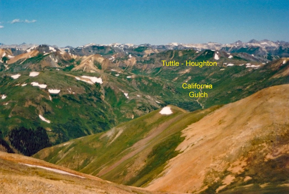
Year Climbed: 2006From the California/Placer Gulch intersection, drive or walk west on the California Gulch Road another .7 mile west and park (if driving) at a place where the road splits briefly and your vehicle can be out of the way of the many ATV's, ORV's and 4WD that will be using this road on a weekend. Coordinates are: N 37° 55' 48.76" W 107° 36' 16.92". From that parking location , begin hiking immediately up toward Tuttle Mtn., a little north of due west. About 200 feet up, pass an abandoned mine and continue on a diagonal ascent toward Tuttle. The hike is mostly on steep, grassy slopes with many flowers and plants if here mid-July. Some times, you may cross some rock fields, and while it is steep, footing is mostly secure and you should be able to ascend rapidly. After about 1,200 feet of gain in a diagonal, westerly direction, you may come to a small basin on the ridge from where you will need to try and figure out where the true summit of Tuttle is. It is a little confusing, but you should able able to figure out where you are and head on off for the true summit. Our calculations turned out to be correct and in a few more minutes, and a little over an hour from the truck, we arrived at the summit. You can observe that the road up California Gulch apparently continues to the head of the basin, then actually crosses north over a high pass and drops into Poughkeepsie Gulch. You may be able to hear and see vehicles on this road far below.
Additional BETA
Links to other information, routes & trip reports for this peak that may be helpful. -
