LoJ: #388 (Pre-LiDAR #400) / 13,313' UN 13313 Formerly UN 13300 C

Peak Summary
Note: G&M notates as UN 13300 C.
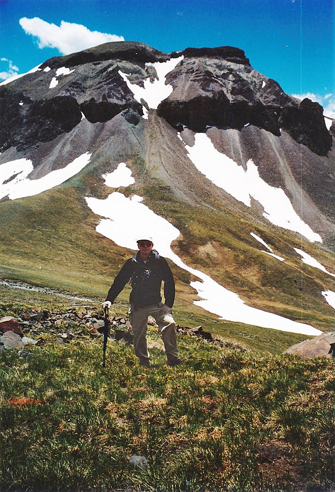
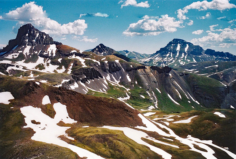
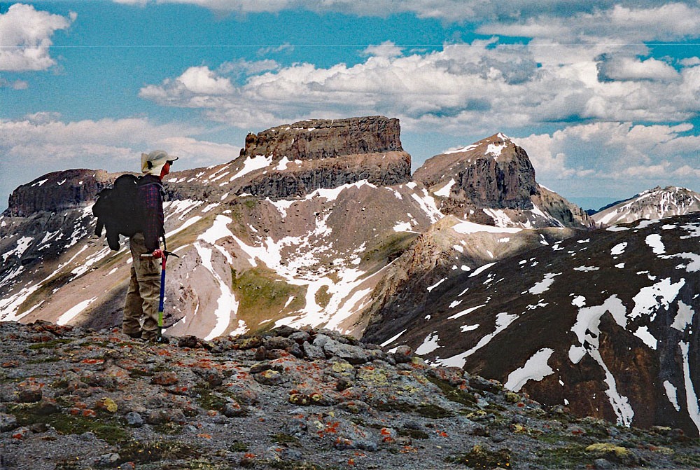
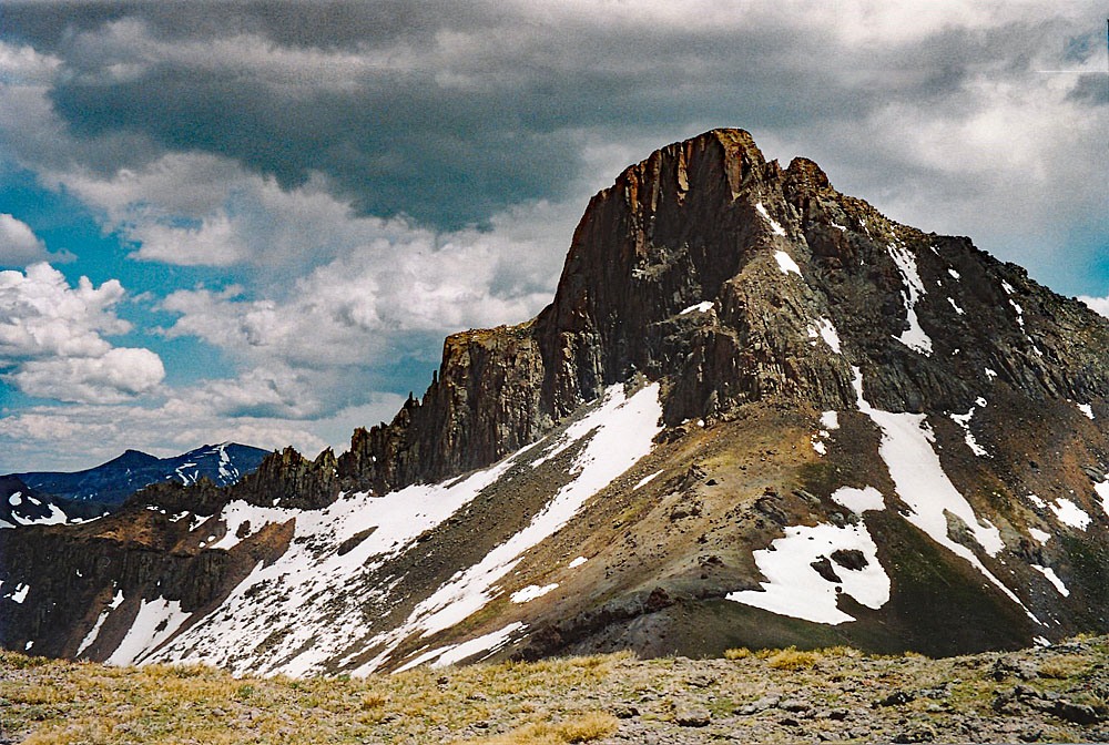
UN 13,300 C is a pleasant Class 2 hike typical to this part of the San Juan Mountains. Vehicle access to the trailhead by way of the North Fork of Henson Creek to Mary Alice Creek is best accomplished with 4WD and good clearance or 2WD with well above average clearance. This summit is sequenced with UN 13,201 and both offer unparalleled views of Wetterhorn and Coxcomb as well as a host of other high summits in this remote section of the San Juans. From the summit of UN 13,300 C, you have a bird's eye view of the final summit pitch on Wetterhorn. Lidar added 13 feet of elevation to the previous interpolated elevation of 13,300 ft.
UN 13,313 C South Ridge Route
-
-
Mary Alice Creek TH
Directions begin from Lake City. From Gunnison, go west on SH50 to the intersection near the beginning of Blue Mesa Reservoir with SH149 and turn south. From Montrose, drive east on SH50 to the east end of Blue Mesa Reservoir for the same turnoff on SH149. Drive west and south on 149 to Lake City, just over 45 miles from the previous intersection. Once in Lake City, watch for either 3rd or 2nd street. Turning west on either will take you to Bluff St. in two blocks and a left turn (south). 2nd St. is considered the "official" access to CR20 which heads west following Henson Creek, but if you take 3rd St., it passes by a nice city park with restroom and picnic tables for those who need a break before proceeding further.
Once on CR20, drive 9.1 miles west to Capitol City on a graded, gravel road passable to passenger vehicles. On the Gunnison National Forest map, this road is labelled as BLM3303. At 5.2 miles into this drive, you'll pass the Nellie Creek Road (FR877) which accesses Uncompahgre Peak and several 13ers located in that area. At Capitol City take the right fork and continue NW on FR870 (aka: CR24) to the Matterhorn Creek trailhead turnoff at 11.1 miles from Lake City. The road becomes rougher but higher clearance SUV's and cross-overs should be able to handle to this point. Coordinates for that turnoff are: N 38° 01' 22.65" W 107° 29' 31.09". Many vehicles will choose to park here if doing Wetterhorn, Matterhorn or Broken Hill.
For Mary Alice Creek, continue driving west for another .75 mile. The road continues to get rougher and may or may not be passable for cross-over type vehicles. A stock 4WD would be a better choice for continuing to Mary Alice Creek. Park in the vicinity of the intersection for the road that turns up northwestward after crossing Mary Alice Creek. That road is the beginning of the trail up Mary Alice Creek.
Camping
In the immediate area, there is a good primitive site just before crossing Matterhorn Creek on the uphill side of the road and a couple other sites shortly after crossing Matterhorn Creek, one on the right, then one on the left. At Capitol City there is some primitive camping, but be aware of private property in that area. Then, heading west up the road to Matterhorn Creek and Mary Alice Creek, there are a few other primitive sites before reaching Matterhorn Creek. On weekends, you can expect most of these to be occupied. On weekdays, you may have your pick. There are no National Forest campgrounds along CR20 between Capitol City and Lake City.
-
From UN 13207
Click thumbnail to view full-size photo + caption
Open This Route in a New WindowFrom the trailhead coordinates strike out to the north on Uncompahgre Trail #226 for what is called Wetterhorn Basin. We followed an old road/trail that climbed steadily and crossed to the east side of Mary Alice Creek about 1/2 mile up. The trail continued north through trees and meadows to a point where it switchbacked at about 11,720 ft. It was here, that we left the trail. Google Earth photos seem to indicate there may be some trail damage from the 2018 - 2019 avalanche season. So you may have to improvise to reach the upper basin.
From the switchback, drop down to the creek, climb up the other side and skirt willows by a group of trees while heading generally west. Head for the south ridge of UN 13,207. As we hiked up the ever steepening slope, we crossed numerous, domestic sheep trails. At 12,320 ft, we gained the ridge, having hiked this far on nice tundra. A nice attraction we observed was a group of Bighorn sheep that were on the ridge ahead of us and kept peering over it, looking down on our approach. By the time we reached the ridge, they had headed on up and over the summit. In the bright, morning sun, we continued hiking north along the ridge. At 12,800 ft., contour to the right, to avoid a rocky, cliff section along the ridge, then regain the ridge for the finish to the fairly broad and flat summit. It only took us a little over two hours to arrive here.
Click thumbnail to view full-size photo + captionRoute Description
Year Climbed: 2004UN 13,313 is sequenced with UN 13,207. One-way mileage and elevation gain are measured from the summit of UN 13,207. Round-trip mileage and elevation gain assume completion of the sequence.
UN 13,313, is located north of UN 13,207 by about 2 miles. It was also just a little west of Wetterhorn. From the summit of UN 13,207 it looked inviting to go north, then northeast, dropping straight down to a saddle at 12,600 ft. and then continue north to the 13,024 false summit just north of the saddle. But the drop from UN 13,207 to the saddle involves a cliffband or a descent down a very steep couloir that opens onto a rocky snowfield. Either way appears dangerous and troublesome when viewed from above so we chose a more roundabout route. From the summit, we headed west, carefully descending through a short cliffband and contouring along very fragile, unstable rock to a saddle between UN 13,207 and 13,129. From this saddle, we descended north down a steep couloir with just a little snow for a while which opened onto a larger patch of snow that made descent a little more enjoyable for a brief time.
At about 12,600 ft., we stopped losing elevation and contoured east to the saddle, having to regain just a little elevation. From here on, it is fairly easy hiking over mostly tundra with minimal amounts of rock all along the ridge, past two false summits to the true summit of UN 13,313 which is a kind of large, flat rocky outcrop. Take time for a leisurely lunch here and take numerous pictures of the spectacular northwest face of Wetterhorn. We watched for climbers on the peak and did spot some descending. You may also survey the head of Wetterhorn Basin and the south side of Coxcomb if you have not already climbed these.
To get back to your vehicle and the trailhead, head back south along the same ridge to the saddle at 12,600 ft. Turn southeast and follow some patches of snow for a quick descent into the head of Mary Alice Creek. At about 12,000 ft, we picked up a trail, cut over to the east a little more and then picked up the original trail we had been on earlier that morning, just a little above the switchbacks, where we had left the trail. The remainder of the hike was an easy stroll back down to the trailhead.
Additional BETA
Links to other information, routes & trip reports for this peak that may be helpful. -