LoJ: #357 (Pre-LiDAR #361) / 13,350' UN 13350 Uncompahgre Pk Formerly UN 13340 B (G&M)
Peak Summary
Accessed from the Middle Fork of Cimarron River, a two mile hike to the unnamed creek coming out of Porphyry Basin and a hike up into that basin, UN13,350 is a pleasant hike until the last 600 feet of gain which turns to steep, small scree. During mid-summer, there should be ample wildflower viewing in the upper basin. Higher clearance vehicle recommended for reaching the trailhead.
UN13,350 North Couloir Route
-
-
Middle Fork of the Cimarron River TH
From either the West Slope or East Slope:
From Montrose, drive east on US50 past Cimarron about 2.7 miles and turn south on County Road/Forest Road 858 that goes to the Silverjack Reservoir. From Gunnison, drive west on US50 past the Blue Mesa Reservoir, down through a narrow canyon section, up over a pass at 8,700 ft., then down a long and winding descent toward Cimarron. The turnoff is one mile past the turnoff for CR864 and just past a small resort on the south side of the highway. It's a long, 22 miles drive back on a graded, dirt road, suitable for passenger cars, but can be dusty and/or washboarded. Continue past the Silverjack Reservoir about a mile and then make a right turn to cross the creek and then make an almost immediate left onto FR861.1. If you fail to make this left turn, you'll find yourself ascending toward Owl Creek Pass. Hikers can also come in from Owl Creek Pass, the road for which turns off from US550, about 2 miles north of Ridgway. That road is CR8 or FR858. Hikers coming from Durango, Telluride, Ouray or Ridgway will probably want to use that approach. In which case, they will need to drive over Owl Creek Pass to near the Silverjack and locate FR861.1 to make the proper turn.For all approaches, once you're on FR861.1, it's a 4.6 mile drive back to the end of the road and the trailhead for the Middle Fork of the Cimarron. We found the road to be generally passable for most vehicles, however, the time we were in here, there had been heavy rains the week before that had left sections of degraded road where small streams had swept across. Smaller passenger cars would have had difficulty getting past those damaged areas. We do not know if and how well they have been repaired, hence, the higher clearance recommendation. (Report from 2017: Some of those minor creek crossings still present a problem for lower clearance vehicles.)
The trailhead area apparently use to be a campground years ago, but the tables and designated sites have been removed. There are now plenty of primitive camp spots on fairly level ground in the trees to use and a vault toilet. There's also a nice meadow shortly after where the trail begins and some other campsites there.
Camping
There are three designated, Forest Service Campgrounds just north of the Silverjack Reservoir. South of the reservoir, where FR861.1 turns off, there's a large, flat primitive area with multiple campsites in and out of the trees as you head back to the trailhead. Then, there is primitive camping at the trailhead as explained above.
Route Description
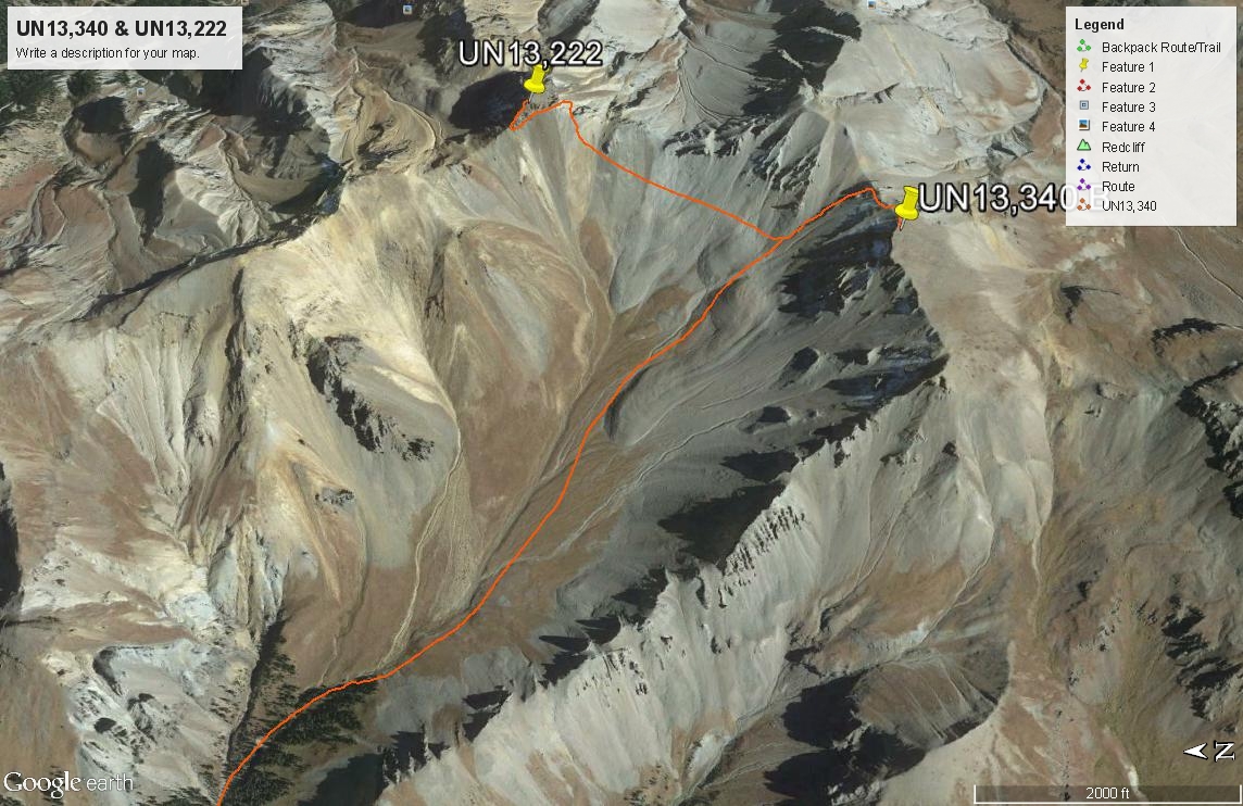
Year Climbed: 2005From the trailhead for Middle Fork Cimarron, walk south up the trail for the two plus miles to the crossing of the creek coming out of Porphyry Basin. Locate a well used trail on the north side of the creek that leads into the upper Porphyry Basin. This trail begins by climbing steeply for a short while, then more gradually as it makes a very long switchback to the north before turning south and bringing you back to the drainage at about the 11,200 ft. contour. Then the trail climbs more gently, coming to a fork in the drainage at 11,400 ft. Across the creek to the south and up on a hillside is a small cabin that appeared to be in use back in 2005. We walked over to it and investigated a little before crossing back over the creek and heading on up valley. Shortly above the cabin, the valley opens up and you'll leave the last trees. This upper basin stretches for about a mile. It is a beautiful, tundra filled basin that earlier in the season would be rife with wildflowers. The most interesting thing we saw in this basin was one lone buck who spotting us, tore off back down the valley and never stopped until he was out of our site.
As the basin gradually turns more easterly, begin veering south, heading for a saddle between the east and west summits of UN 13,350. This elevation is an interpolated one. The east summit shows an elevation on the survey map of 13,315 ft. The west summit has no elevation on the map, but the contours indicate it must be at least 13,320 ft. As we headed for the saddle, we were able to follow some tundra for a while, but eventually had to enter the shallow gully and begin scrambling up the scree and dirt on poor footing. We had to negotiate about 600 vertical feet of this stuff and as we approached the saddle, it became very difficult to maintain footing. At the saddle, a difficult section along the ridge compelled us to contour on the north side through the head of another steep gully and climb further up. This last scramble up was even worse for footing, requiring us a couple of times to use our ice axes plunged into the dirt to secure our feet. But once on the ridge again, it was easy walking on up to the summit and only required a few more minutes. The summit is composed of a lot of large, flat, brittle rocks and there was a cairn. To the south, you can clearly see El Punto. From this summit over to it would be an easy walk, but it appeared that gaining the summit from the north side would be a difficult feat. Adding UN13,340 to an El Punto day would be easier than coming up Porphyry Basin as our route has you do.
Descend as you came (on the scree this would be a fast one) or consider contouring over and bagging UN13,222 as well. It would make little sense to leave that one hanging, but it won't be easy.
Additional BETA
Links to other information, routes & trip reports for this peak that may be helpful. -
