LoJ: #335 (Pre-LiDAR #337) / 13,382' UN 13382
Peak Summary
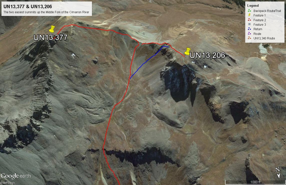
Along with UN13,215, these are the two easiest summits in the Middle Fork of the Cimarron River. Class 2, mostly tundra stroll. The only deterrent is the overall mileage. Lidar data increased elevation by 5 feet.
UN13,382 SW Ridge & Saddle Route
-
-
Middle Fork of the Cimarron River TH
From either the West Slope or East Slope:
From Montrose, drive east on US50 past Cimarron about 2.7 miles and turn south on County Road/Forest Road 858 that goes to the Silverjack Reservoir. From Gunnison, drive west on US50 past the Blue Mesa Reservoir, down through a narrow canyon section, up over a pass at 8,700 ft., then down a long and winding descent toward Cimarron. The turnoff is one mile past the turnoff for CR864 and just past a small resort on the south side of the highway. It's a long, 22 miles drive back on a graded, dirt road, suitable for passenger cars, but can be dusty and/or washboarded. Continue past the Silverjack Reservoir about a mile and then make a right turn to cross the creek and then make an almost immediate left onto FR861.1. If you fail to make this left turn, you'll find yourself ascending toward Owl Creek Pass. Hikers can also come in from Owl Creek Pass, the road for which turns off from US550, about 2 miles north of Ridgway. That road is CR8 or FR858. Hikers coming from Durango, Telluride, Ouray or Ridgway will probably want to use that approach. In which case, they will need to drive over Owl Creek Pass to near the Silverjack and locate FR861.1 to make the proper turn.For all approaches, once you're on FR861.1, it's a 4.6 mile drive back to the end of the road and the trailhead for the Middle Fork of the Cimarron. We found the road to be generally passable for most vehicles, however, the time we were in here, there had been heavy rains the week before that had left sections of degraded road where small streams had swept across. Smaller passenger cars would have had difficulty getting past those damaged areas. We do not know if and how well they have been repaired, hence, the higher clearance recommendation. (Report from 2017: Some of those minor creek crossings still present a problem for lower clearance vehicles.)
The trailhead area apparently use to be a campground years ago, but the tables and designated sites have been removed. There are now plenty of primitive camp spots on fairly level ground in the trees to use and a vault toilet. There's also a nice meadow shortly after where the trail begins and some other campsites there.
Camping
There are three designated, Forest Service Campgrounds just north of the Silverjack Reservoir. South of the reservoir, where FR861.1 turns off, there's a large, flat primitive area with multiple campsites in and out of the trees as you head back to the trailhead. Then, there is primitive camping at the trailhead as explained above.
-
From Middle Fork of the Cimarron River TH via Middle Fork Cimarron Base Camp
From the trailhead, walk south past some willows and into a large meadow. The easy-to-follow trail #227 continues south gaining elevation up the drainage, passing through both forest and meadow. For the first two miles, it gains elevation rather gently. At 2.2 miles, the trail crosses the creek coming out of Porphyry Basin. The USGS map indicates a footbridge here. We found no such thing in 2005, but crossing the creek was not that difficult. Note that a path into Porphyry Basin heads up from this crossing area, on the north side of the creek, before you cross the creek. On this first & lower section of trail, do not be surprised to see cattle and in wet conditions, they can really muck up the trail.
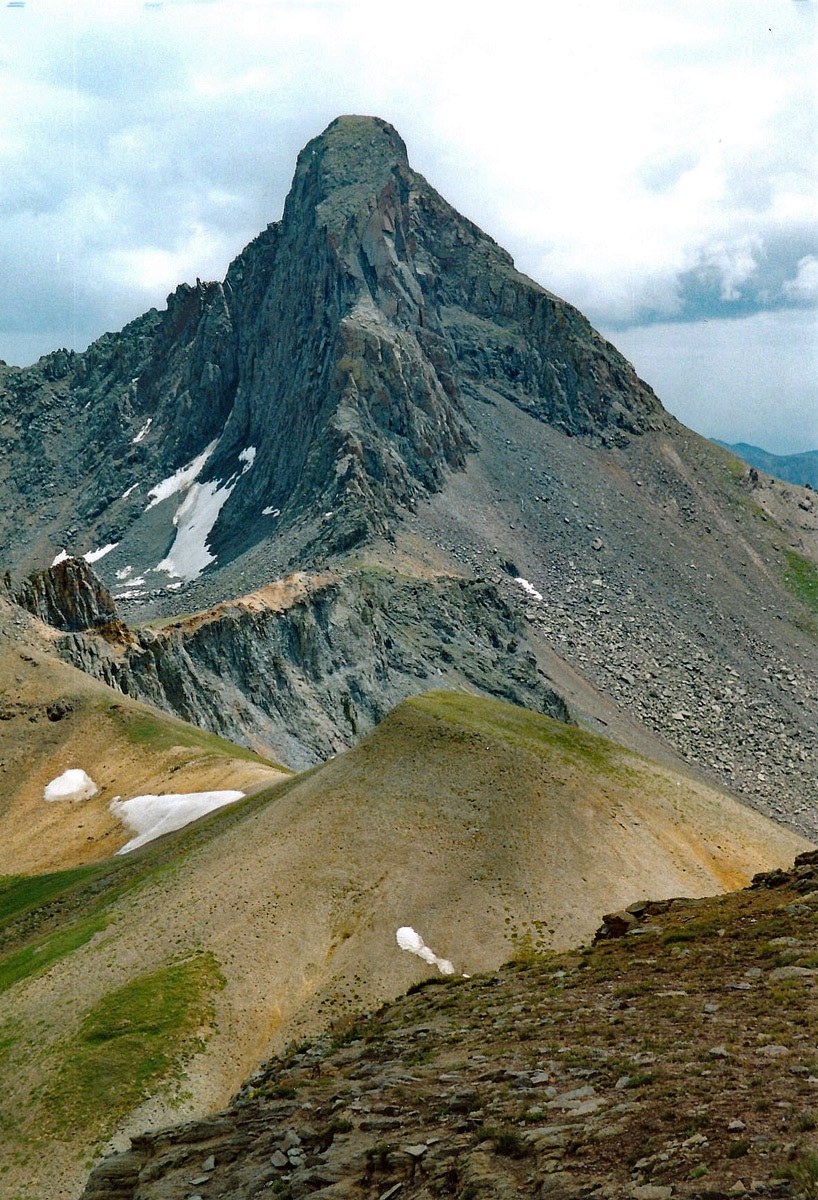
Continue hiking on past the creek crossing for another 2 miles with the trail steepening and crossing through an avalanche run out area with downed timber. At about 3 miles from the TH, you'll come to a nice meadow area with lots of flowers mid-summer. Between the Porphyry crossing and this meadow, the views of the east side of Precipice Peak are spectacular with a dramatic array of cliffs, angular rocks, spires and pinnacles. As you continue hiking, there will be some possible campsites to consider. Most tended to be small and somewhat sloping with old cow pies. At about the 11,400 foot area, we found a usable campsite, but the best campsite we found was continuing all the way to where the trail takes a turn to the east and begins its ascent up to a pass just north of the Heisshorn. If you continue on this trail #227, it drops over a tundra saddle and into the East Fork of the Cimarron to become #228. There is also another trail that heads off to the right/west to cross the creek and then ascends to the base of Coxcomb Peak. This trail is called the Coxcomb Trail #132. In places it is not very visible and marked by stakes/posts. It does not show on the USGS but is on the Trails Illustrated map #141.
If you'll leave the main trail where it makes this turn and walk south, crossing another side drainage, but still remaining on the east side of the Middle Fork, there is an excellent campsite which at the time was being used by horse packing groups. If unoccupied, this makes an excellent base camp for ascending El Punto and Heisshorn together, and then UN13,377 and UN13,206 together.
Camping
The campsite we recommend was somewhere near these coordinates taken from our best guess on Google Earth. Elevation was right around 11,600 ft.
Campsite Locations
Middle Fork Camp N 38° 05' 14.16", W 107° 31' 08.91"
Open This Approach in a New Window
Click thumbnail to view full-size photo + captionRoute Description
Year Climbed: 2005The route description begins from the campsite coordinates provided and assumes a backpack trip up the Middle Fork. Mileage and elevation gain is measured from that campsite, which is just south of where the main trail begins to leave the drainage and turns east toward the 12,595 ft. pass.
There’s not much to say about the route here. You can see UN13,382 and UN13,215 at the head of the valley as you walk south up valley, by the northern slopes of the Heisshorn, gazing apprehensively at it’s precipitous north face. Continue walking into the upper basin on easy tundra. Then walk more steeply up to the saddle between UN 13,382 and 13,215. At that easy saddle, you will be greeted by an impressive view of the north side of Wetterhorn Peak, with its rugged cliffs and sheer walls. You can get some impressive photos here if the weather cooperates. Begin hiking up to the summit along the ridge. Some prominent rock formations on the ridge may cause you to stay left and follow a natural contour to a saddle that leads to the final, summit approach. The remainder of the hike to the summit, is without difficulty over tundra and rock.
Of note: In 2005, we found a summit register with an individual who signed in and indicated they had climbed UN13,382 by traversing from the Heisshorn summit along the ridge. That ridge traverse looks quite complicated and impressive. We do not recall who made that entry.
Once you've summited UN13,382, then return as you came or head west and northwest back along the connecting ridge over to UN13,215.
Another alternate approach would be this: From the suggested Base Campsite, locate the "Coxcomb Trail #132 that splits off from the main Middle Fork Trail, crossing the creek and heading SW. This Coxcomb Trail is near where the Middle Fork trail turns east away from the creek to climb to a pass. Follow the Coxcomb Trail which will land you on a saddle between Coxcomb and 13,092. Walk SE along the ridge crest over 13,092, then over 13,215 to continue on to 13,382.
Additional BETA
Links to other information, routes & trip reports for this peak that may be helpful. -