LoJ: #285 (Pre-LiDAR #277) / 13,459' "Pear Peak" Formerly UN 13462
Peak Summary
UN 13,462 B in G&M (aka "Pear Peak"). A rocky Sawatch summit with either a Class 4 or Class 3 ascent route. 4WD best for access.
Pear Pk North Face/E Ridge Route
-
-
Clear Creek/Winfield/Apostles TH
From Leadville, drive south a little over 19 miles on HWY 24 to the turnoff for Clear Creek Reservoir (CR390) and head west. The turn is less than 2 miles south of "Granite." From Buena Vista, drive north just under 15 miles to the same turnoff. Drive west on graded dirt road 11.7 miles to Winfield. As the road approaches Winfield, it will become a little more narrow and likely to have some potholes. Because of heavy use, this road is often washboarded badly. At Winfield, turn south and cross the creek and continue south, then SW on CR390.2B. About 100 yards after crossing the creek, passenger cars may want to park because the road greatly deteriorates beyond there. Higher clearance vehicles may continue. 4WD is not really required for the remainder of the drive to the end of the road. At a little over .7 mile after crossing Clear Creek, just south of Winfield is the turnoff for the blocked road to Lulu Gulch, UN 13,462 A and Browns Peak. From Winfield it's about 2.25 miles to the end of the road and some limited parking. This trailhead is used for both Huron Peak and routes to the Apostles.
If using this general trailhead description for access to peaks up the Lake Fork of Clear Creek (Clohesy Lake), then do not drive all the way to Winfield. Instead, you'll need to turn left at 9.8 miles in from US24 and drive down through the few cabins that comprise "Rockdale," ford Clear Creek and drive to the Clohesy Lake trailhead with a starting elevation of 10,900 ft. 4WD required for this access, otherwise, walk it and enjoy the frigid and sometimes dangerous crossing of Clear Creek.
Camping
For the access to Huron and the Apostles, best camping opportunities are along the final two miles to the trailhead from Winfield. There are several at-large spots available. Camping before Winfield can be difficult because of private property and the large number of people coming to climb Belford, Oxford and Missouri.
There are good campsites for backpackers in the vicinity of "Hamilton" along the Huron Route and the trail up toward the Apostles. There are also good campsites in the meadow just north of the rock glacier at about 11,400 feet or a little lower.
If heading up the Lake Fork toward Clohesy Lake, there is at-large camping at the trailhead which is at a large, open meadow area that's relatively flat. Coordinates are: N 38° 57' 15.48" W 106° 24' 32.64"
-
From Clear Creek/Winfield/Apostles TH via Clohesy Lake Trailhead
This approach description can be used for either foot travel or vehicle. It begins from the four cabins that comprise "Rockdale." Follow the driving instructions for access to Winfield, but before driving all the way into Winfield, turn left at about 9.8 miles in from US 24 on CR390, onto the unmarked road that leads past the cabins and drops down to Clear Creek. This is FR381. If you're in a passenger car, there's some room to park before the creek crossing. Whether on foot or 4WD, ford Clear Creek. The earlier in the season you do this, the more dangerous. We've crossed before around the 4th of July with water trying to come in at the doors of our Jeep Cherokee. Wading can be a real challenge. Being swept away, even in a vehicle is quite possible. Once across, it's about 3 miles straight south to the trailhead parking at 10,880 ft. In the past, this road was never a very difficult 4WD route, but over the years since we have visited, it's not difficult to surmise that it has deteriorated. Please respect the private property ahead that's situated around Clohesy Lake and follow the designated trails. Trailhead coordinates are: N 38° 57' 15.48" W 106° 24' 32.64"
Camping
There is plenty of room at the trailhead for at-large camping, but be sure and respect private property. Back out on CR390, there are numerous spots all along the drive in from US24.
Open This Approach in a New Window
Route Description
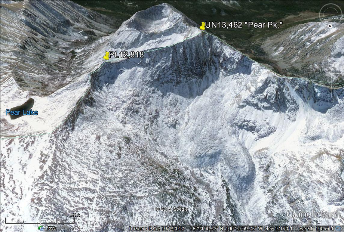
Year Climbed: 2000From the trailhead north of Clohesy Lake, follow the trail south that contours above the east side of Clohesy Lake and continue past the turnoff for Missouri mountain. Drop back down to valley level after the lake and continue walking on the usually somewhat wet trail south for a little over 2 miles. All along the way, you'll enjoy great views of Pear Peaks' rugged north face. In tundra basin at about 12,000 ft., depart the trail and walk on tundra to a rock-covered bench area below the left side of the north face. From here, you'll need to make a decision as to ascent route. The way we went up was fairly difficult (approaching Class 4) with some exposure. If you prefer an easier route, what we describe as our descent route can be reversed and should not be any worse than some modest 3rd class scrambling up a loose couloir.
To continue with the north face ascent, from the rock bench, turn SSE some and continue ascending on either a snowfield (early season) or rubble for another 400 feet in elevation. Watch for an upward sloping, narrow bench that heads more to the left and works up to the east ridge of the peak. If you don't find this bench, you'll probably encounter rock ribs to clamber around on until you intersect the east ridge at about 13,100 - 13,200 ft. (?) We did this in early enough season where snow forced us onto some of these ribs. The last bit of scrambling to the east ridge we found a little unnerving and exposed 4th class work.
Once on the narrow east ridge, you'll find the going easier than the exposed north face, but still slow, rocky, and exposed at times with a few minor obstacles. Continue on mostly Class 2+ to the summit, where you'll enjoy and view all the way back down the Lake Fork valley.
For descent, head down the slow east ridge form the summit. As you approach Pt.12,818, there will be two notches to negotiate. The first will require a brief drop and then you'll need to regain the ridge. The second drop is more difficult with both a steep down climb and re-ascent. Since by the time we reached this location it had rained and all the rocks were quite wet and slick, we chose to head down to the right from the ridge into a steep couloir, exit the couloir about 200 feet down and then contour around the base of Pt.12,818 until we could intersect the ridge again. Cross back to the NW as you find a way across the ridge and head down a broader and less steep gully back down into the rocky basin. Find your way back to the trail and walk 3 more miles back out to your waiting vehicle north of Clohesy Lake, if you have 4WD.
Bonus Points: If you have time, since you've already invested over 3 miles of hiking to climb Pear Peak, it would make a great deal of sense to go ahead and include UN13,762 (aka: Silver King Peak) in your trip by descending to Pear Lake, hiking about one mine SSE and then ascending east up the very rocky and tedious slopes.
-