LoJ: #244 (Pre-LiDAR #247) / 13,517' Silver Peak Formerly UN 13513
Peak Summary
A fairly typical Sangre de Cristo, Class 2 hike that accesses this peak from the Lakes of the Clouds area on the east side of the range. Very scenic, good backpacking/camping possibilities or a longer out-and-back day hike. This summit combines easily with UN13,490 (Cotton King Peak) or Spread Eagle Peak and "Peak of the Clouds" depending on how much time and energy you have. Lidar added 4 feet of elevation.
Lakes of the Clouds/East Flank Route
-
-
Gibson Creek TH
From the Town of Westcliffe: Alternate A: Drive north on HWY 69 and in about a mile, turn west onto CR170 (Hemenway Road) which will first head NW, then west. CR170 will take a brief jog to the north and then back to the west at CR175. Continue west and make another jog to the north at Pines Rd. then back to the west again. At a "Y" intersection, turn left onto CR171, (Ute Mesa Trail, but the Forest Service map seems to identify this as FR173. There should also be a Forest Service sign here for the Gibson TH.) driving through open fields and homes to CR172 (N. Taylor Road) where you will turn right (west), then head SW to the trailhead. The road officially ends in a short circle. A road continues on to private property. A trail heads north from this trailhead location to intersect the Rainbow trail (N38° 08' 28.87" W105° 36' 04.92"). There is private property all along this access. Please be respectful. At the bottom of all this description is a link to the San Isabel NF trailhead description for Lake of the Woods Trail and the Gibson Creek TH.
Alternate B: From the main intersection of Highways 69 and 96 in Westcliffe, drive south on 69 .3 mile and turn west (right) onto Hermit Road (CR160). Drive 5.9 miles west and then the road will turn north to intersect CR172. Hermit Road becomes Sampson Ridge Road as it switchbacks to make the connection, passing residences and ranches and working around "The Hogback." At CR172, turn left to finish the short drive to the TH. It's another 1.5 mile to the trailhead from the turn off Hermit Road. The last .2 mile on 172 may be rough and rutted according to one more recent source. Passenger cars may have some difficulty. If you're unable to park at the trailhead parking, park back along the road but be respectful of private property.
For another trailhead access to either South or North Brush Creeks, see the Ducket Creek TH, which is about 5 miles north on the Rainbow Trail of the S. Brush Creek trail and probably has less unnecessary elevation gain and loss. Look under our trailhead listing.
For an alternate access to the west side of the Sangre de Cristo Range and peaks in the same areas as Lake of the Clouds, try the "Cotton Creek" trailhead. Look for that name under the Trailhead listings. We have never used this trail, but it does show on the Rio Grande National Forest map and the Trails Illustrated Map # 138. The link below goes to the Rio Grande National Forest description of the trail:
http://www.fs.usda.gov/recarea/riogrande/recreation/hiking/recarea/?recid=29310&actid=50
Forest Service description of Lake of the Woods Trail and Gibson Creek TH: http://www.fs.usda.gov/recarea/psicc/recreation/recarea/?recid=12756&actid=104
Camping
Since there is so much private property along the access to the Gibson trailhead, we do not advise camping. Even at the TH, there is private property close by. You may be able to camp right at the TH but probably nowhere else on the way in.
Route Description
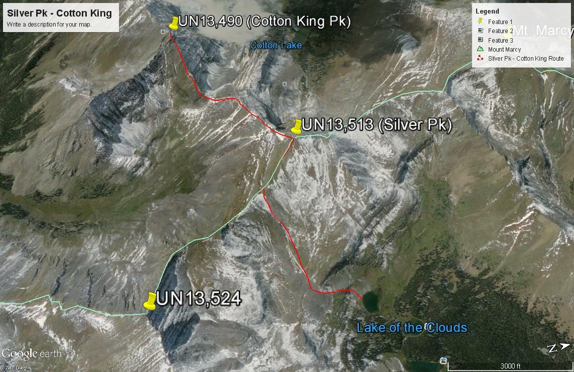
Year Climbed: 1996From the Gibson Creek Trailhead, walk northwest on a trail past private residences to intersect the Rainbow Trail or find whatever access is currently provided to the Rainbow Trail. Head north on the Rainbow and after about .7 mile, you should come to the well-marked intersection for the Lakes of the Clouds trail turning west (left). Older maps like the USGS quad will not show this trail. The USGS quad does show a trail to the lakes on the north side of Swift Creek, but it is not necessary to go to that trail. The trail starts out more like an old roadbed that's large rocks and ruts. Follow the trail on the south side of Swift Creek 2.25 miles, crossing Swift Creek at about 10,100 ft. to its north side along the way and intersect the trail on the north side of Swift Creek at about 10,700 ft. Shortly above here is a good campsite. Continue another 1.3 miles west and southwest to the lakes. Take a nice break. Stronger hikers can reach this location in about 2 hours from the TH. There are excellent campsites at the lakes, some of which are used by pack-horse groups. In the earlier part of the summer, expect mosquitoes.
From the lakes, continue walking SW to the third lake where the distinct trail will play out and plot a course south toward an upper basin with the 12,226 elevation marker on the USGS quad, hiking up steep, grassy slopes and passing through lower willows. In this upper basin, there's something that resembles a lateral moraine you can follow for a while aiming for an even higher tundra-covered basin above 12,400 feet. At whatever point you choose, aim for the SE ridge coming off Silver Peak and hike up steeper, mostly tundra slopes to that ridge. In earlier season and depending on snowfall for that year, an ice axe and micro spikes could prove useful on this approach. Once on the ridge, follow it NW to the easy summit, about 1.5 hours from the third lake. As always with peaks on the central spine of the Sangre de Cristo, enjoy the magnificent view both east and west. From here, we highly recommend that you at least add UN13,490 (Cotton King Peak) to your agenda for the day. If you choose not to, your round trip hike back to the trailhead will be 11.5 miles with about 4,400 feet of gain. If you add on Cotton King, that will add a little over 2 more miles of hiking and at least another 1,000 feet of elevation gain. Round trip time for this hike including both summits was about 9-10 hours for us.
-