LoJ: #630 (Pre-LiDAR #637) / 13,006' UN 13006 Formerly UN 13001
Peak Summary
Another easy Class 2 walk-up with some interesting rock formations while approaching the summit. Trail access most of the distance and trailhead accessible by passenger car. This once lowliest of the 13ers was elevated an additional five feet to 13,006 ft. by Lidar. This summit could be easily combined with the Geissler summits, one of the new Lidar summits - UN 13556 or UN 13220.
UN13,006 SE Ridge Route
-
-
Roaring Fork River TH
The name for trail #1996 is "The Lost Man" trail. It has two access points off Highway 82 out of Aspen. The first access is 14 miles east of Aspen and is a large parking area on the north side of the highway, across from the Lost Man Campground. This section of the trail leads up to South Fork Pass and Lost Man Lake. If accessing the Williams Mountains, this is the shortest and easiest access.
The other access point is 18.5 miles from Aspen, still on Highway 82, at the last switchback before the final climb to the top of Independence Pass. This access, I am calling "The Roaring Fork River" trailhead to distinguish from the Lost Man TH. Parking here is on the north side of the highway at the switchback. Parking is limited here and fills quickly on weekends. If coming from the east slope, you'll need to drive north from Buena Vista or south from Leadville and turn west on Highway 82, drive past the Twin Lakes and continue to the summit of Independence Pass. Drive down west from the summit and the trail head will be at the first switchback you come to.
Camping
Most at-large camping along the west side of the Independence Pass road has been shut down, but there are several Forest Service, fee type campgrounds out of Aspen. They are in order starting from the farthest from the TH: Difficult Creek, Weller, Lincoln Gulch and Lost Man. If you're coming from the east slope, you're best off camping at any number of at-large spots on the east side of Independence Pass, in the upper regions of Lake Creek. We like the Graham Creek area where a diversion tunnel comes out and empties into Lake Creek.
Campsite Locations
Graham Creek › N 39° 04' 53.35", W 106° 32' 18.13"
Click thumbnail to view full-size photo + captionRoute Description
Year Climbed: 2003This hike begins from the east end of the Lost Man Trail at the switchback just before the final gain to the summit of Independence Pass. We're calling this trailhead the "Roaring Fork River" TH.
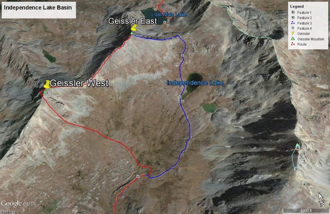
From the trailhead at highway 82, head north up the well used trail #1996 that goes to Independence Lake, following along the creek. In a short distance, a trail forks to the left, just after crossing a creek, that leads up to Linkins Lake. Don't turn onto that one. Continue on up valley, following the trail which crosses back to the east side of the creek after a while. This trail passes through many willows. The old trail on the west side of the creek that the USGS map shows going to a pass between the two Geissler peaks is no longer in use. Continue hiking along the main trail with plenty more willows. Eventually, you'll get out of most of the willows as you approach Independence Lake. This upper basin is a vast tundra-filled bowl. If not for all the human traffic, it would probably host a large elk herd.
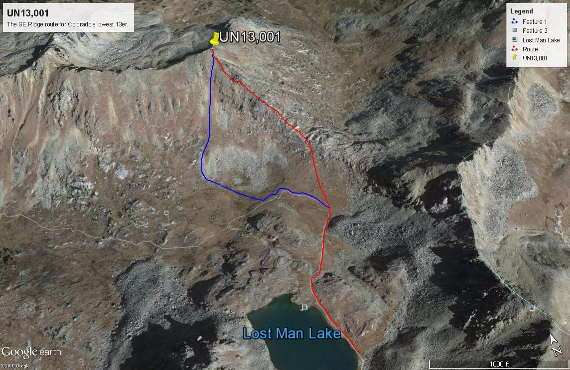
Continue north on the trail past Independence Lake to the pass, which we call "Lost Man Pass." Drop down on the other side toward Lost Man Lake. You might as well hike all the way down to the lake, because a tongue of a rock glacier coming off UN13,366 (unranked) extends down into the valley and prevents contouring across the valley east of Lost Man Lake unless you enjoy rock-hopping your way across such things. Continue past the lake and drop another 200 feet and then depart the trail and head toward the saddle between UN13,006 and unranked UN13,150. Hike up to the saddle on mostly tundra with some minor rock. At the saddle, turn and head NW up along the ridge crest.
Once at the saddle, things turn a little more interesting. As you hike north along the ridge, you'll encountered large, block type rock formations to negotiate. This makes an otherwise boring hike kind of interesting a few times as you clamber around these great blocks and avoided small cliffs. As you near the summit, you may find yourself slipping well below the ridge to avoid some obstacles. In fact, we came up to the summit from directly south of it for the very last portion. The summit itself is a rocky affair with a large cairn and not any comfortable places to sit except on some of the tilted boulders.
While visiting here, you can observe the many hikers on the trail below or gaze off toward the Williams Mountains and plan your next climb there, if you have not already done them. For the descent, you can head straight south off the summit by going down a steep, tundra and scree-like slope that will allow quick descent to an attractive group of small ponds with lush, green grass that reminded us of a golf course. We made this descent in 15 minutes. Pick up the Lost Man Trail, hike back up to Lost Man Lake, back over the pass and the remaining two miles back to your vehicle.
Additional BETA
Links to other information, routes & trip reports for this peak that may be helpful. -