LoJ: #573 (Pre-LiDAR #574) / 13,094' UN 13094 Formerly UN 13093
Peak Summary
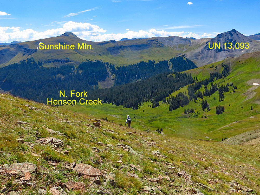
UN 13,094 (Formerly UN 13093), east of Dolly Varden, is a Class 2 hike from the upper reaches of Henson Creek, located on the east side of Engineer Pass. From Lake City, our proposed trailhead can be reached with higher clearance vehicles. From Silverton a 4WD with good clearance is required. This summit pairs well with Sunshine Mountain for a medium length day hike on mostly tundra terrain.
UN 13,094 Via Dolly Varden Mtn. Route
-
-
Henson Creek West TH
Thee are two main access routes for the summits located at the western end of Henson Creek; one from Lake City, the other from Silverton.
These directions begin from Lake City. From Gunnison, go west on SH50 to the intersection near the beginning of Blue Mesa Reservoir with SH149 and turn south. From Montrose, drive east on SH50 to the east end of Blue Mesa Reservoir for the same turnoff on SH149. Drive west and south on 149 to Lake City, just over 45 miles from the previous intersection. Once in Lake City, watch for either 3rd or 2nd street. Turning west on either will take you to Bluff St. in two blocks and a left turn (south). 2nd St. is considered the "official" access to CR20 which heads west following Henson Creek, but if you take 3rd St., it passes by a nice city park with restroom and picnic tables for those who need a break before proceeding further.
Once on CR20, drive 9.1 miles west to Capitol City on a graded, gravel road passable to passenger vehicles. On the Gunnison National Forest map, this road is labelled as BLM3303. At 5.2 miles into this drive, you'll pass the Nellie Creek Road (FR877) which accesses Uncompahgre Peak and several 13ers located in that area. At Capitol City take the left fork which is the "Alpine Loop Road" that will lead over Engineer Pass, but you won't be driving quite that far. This is the continuation of BLM3303. On Google Earth, this is still CR20. Continue driving west past the "Rose Cabin" on the old USGS map. (Note: About 1500 feet east of the Rose Cabin is a solar powered vault toilet on the south side of the road, frequently used by visitors to this area.) From that vault toilet pullout, it's about another 1.7 miles west to our suggested parking spot and trailhead which is nothing more than a pullout on the north side of the road at the coordinates provided. If you come to a beautiful log cabin perched on an overlook of the valley with a foot bridge leading over the creek to the cabin, then you've gone a little too far.
From Silverton: From the Town of Silverton, drive east on the main road through town to where the paved road splits one block past the courthouse and veer right onto the blue-signed County Road 2 (set odometer here) for 4.2 miles of nicely graded dirt road to Howardsville. (On Trails Illustrated map #141, this road is labeled #110. Pavement ends after 2 miles. This road is also known as "The Alpine Loop Road and BLM 4500.) From the Howardsville intersection, continue north another 4.3 miles to the old site of Eureka. The road will cross to the west side of the Animas River and continue up a steeper shelf section. The road begins to get a little more difficult and enters a more narrow section of the Animas River canyon. At about 10,740 ft., the valley begins to widen out again. In that location, another road heads off to the left for Picayne Gulch. It is possible to reach UN 13,075 and Hanson Peak by going up this way, but the lower section of this road is intensely steep, so only for lower gear ratio 4WD vehicles. For the Henson Creek West TH, stay on CR2 and follow directions & road signs to Engineer Pass. This will require 4WD. The 4WD track circles the west side of Engineer Mountain, crosses the pass and then begins its descent toward the upper reaches of Henson Creek. When you reach a switchback in the first trees, in a couple more curves will be the nice log cabin mentioned above. Continue just past the cabin to the pullout on the north side of the road.
Camping
There are several primitive sites to choose from all along CR20 all the way up to our proposed trailhead, however, there are no National Forest campgrounds. At Capitol City, there is some limited camping there, but there's also private cabins & property so exercise some discretion and this area can be very popular on weekends. At the vault toilet near Rose Cabin, if you drive a short distance on a road there past the toilet, there's room for a couple vehicles. Just after Rose Cabin, where the main road veers right, there's a CR20X that stays down closer to the creek. There are several good primitive sites in there, but again, be aware of private claims. The only "facility" in all this area is the vault toilet at the coordinates provided below.
Campsite Locations
Vault Toilet › N 37° 58' 34.23", W 107° 32' 03.52"Elevation 10,850 ft.
Click thumbnail to view full-size photo + captionRoute Description
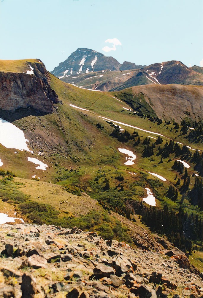
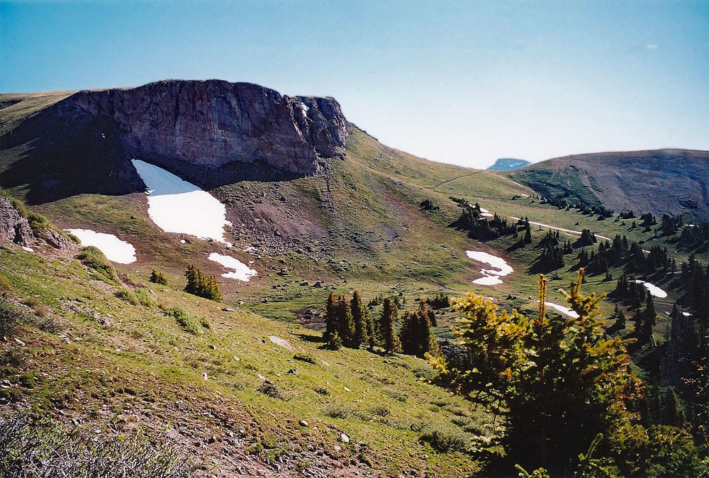
Year Climbed: 2004From our suggested parking spot, walk back down the road to get back on the east side of Henson Creek. Walk north from the road just a little and then turn east. Cross below an entrenched ravine and then begin the mostly grassy ascent to Dolly Varden Mtn. by hiking up along the east side of the ravine in open trees for a while. This route will take you onto a broad ridge with more open trees to about 12,200 ft. Much of the south and southwest flank of Dolly Varden has an extensive area of rubble/talus. This route will avoid as much of that rubble as possible. Above the trees, there will be a brief, flatter tundra area before getting into the rock. For the next 400 feet of elevation gain, work your way through the talus. At 12,600 feet, things begin to level out. From there on, you are arriving onto the large, NW sloping summit dome of Dolly Varden. Hike on through mostly tundra, chiprock and embedded rocks to the true summit which is close to the ridge that connects Dolly Varden with UN 13,094. Might as well tag this high 12er summit for another feather in your cap.
From Dolly Varden head east and down to the saddle between it and UN 13,094. The summit is beyond the saddle, with about a 500 foot gain over large, broken, steep rock. It appears rather intimidating, but goes without any real problem. In about 45 minutes, we were standing on the small summit enjoying the nice, clear weather. While on the summit of UN 13,094, study the route over to Sunshine Mtn., while ingesting some food for the two-mile hike over there if you intend to include it in your day. Sunshine appears to be a mostly grassy walk over easy terrain, but it took us over an hour to cover it all.
Additional BETA
Links to other information, routes & trip reports for this peak that may be helpful. -