LoJ: #569 (Pre-LiDAR #573) / 13,101' "Tomboy Peak" Formerly UN 13095
Peak Summary
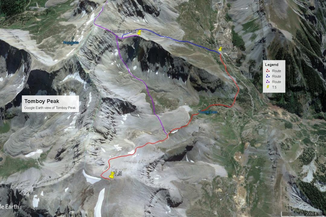
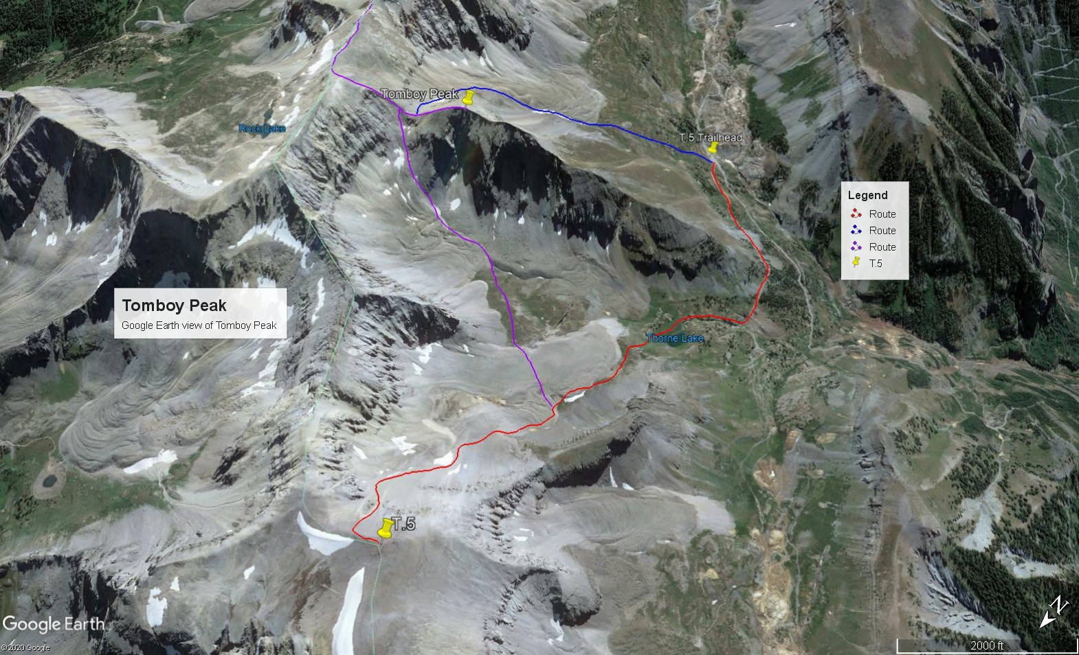
"Tomboy Peak" is an unofficial name given to previously designated UN13,095 (now UN13101)and is located above the Tomboy Mine on the Imogene Pass road between Telluride and Silverton. The trailhead we suggest requires a 4WD with good clearance and begins at the Tomboy Mine. Easiest and quickest access is from the Telluride side, but coming in from Ouray is certainly doable and offers a chance to jeep a scenic and spectacular pass. The route to Tomboy Peak is a Class 2, very rocky ascent. The peak pairs easily with Chicago Peak and T.5 which can also be done from the same trailhead. Lidar increased the elevation of this summit by 6 feet, from 13,095 to 13,101 ft.
Tomboy Peak via Middle Basin Route
-
-
Imogene Pass/Tomboy TH
The trailhead may be reached from either Telluride or Ouray. It will be a longer drive on 4WD road from Ouray. Either access requires 4WD with good clearance. The Imogene Pass road is generally far better than the Black Bear Pass road, but should not be underestimated. Local jeeping groups rate it a class 4 or 4.5 out of 5 classes. There's still plenty of rocky sections, tight curves and narrow sections with drop-offs. We would not recommend longer bed pickups or similar vehicles. We have driven this road several times in the past with a Jeep Cherokee Sport and once up from Telluride with a Toyota T-100 pickup.
From Ouray, drive south out of town on US550 to the first switchback (about .4 mile) and watch for the turnoff for the "Camp Bird Road," (Ouray County Road 361). Drive on graded dirt to the well-marked turnoff for Imogene Pass near five miles in from the highway. On the Uncompahgre NF map, the Imogene Pass road is labeled as 26B. On Trails Illustrated #141, it is listed as FR869. Proceed up the pass, stop and admire the view at the summit, then drive on down the Telluride side to the Tomboy Mine ruins. About a half mile past Tomboy is a road that angles off to the right. Park here at the coordinates provided above.
From Telluride, the turnoff for Imogene Pass is near the center of town. Drive into town on HWY145 which becomes W. Colorado Ave. Turn left onto N. Aspen St. and drive 2 blocks. Turn right on W. Galena St. and drive 1 block. Turn left onto N. Oak St. and drive one more block. The graded dirt "Tomboy" road takes off to the right. Follow this spectacular road as it rises high above Telluride, and winds through different drainages and varying forest. It will be a slow 3 - 4 miles to the coordinates provided above for the vehicle park, where a road angles off to the left. Just past the turnoff, the main Tomboy Road crosses a creek and just beyond there are the ruins of the Tomboy Mine. From the Telluride side, this road is labeled "K68." On Trails Illustrated map #141, it shows as FR869.
Camping
For this access, there are a limited number of camp spots as you drive up the first few miles of Ouray County Road 361. One spot is called "The Angel Creek Campground," followed by the "Thistledown" campground. (See links below) Be careful regarding private property. In past years, we had been able to car camp in the vicinity of where the Governor Basin road turns off from the Yankee Boy Basin road. This may no longer be allowed. Then, there's a good campsite if you're able to drive up the Governor Basin road at one of the switchbacks at about 11,360 ft. at these coordinates: N 37° 58' 37.52" W 107° 45' 42.57"
Link to Angel Creek CG http://www.fs.usda.gov/recarea/gmug/recreation/camping-cabins/recarea/?recid=32524
Link to Thistledown CG http://www.fs.usda.gov/recarea/gmug/recreation/camping-cabins/recarea/?recid=32818
From the Telluride side, there's really little good camping close by. There is a designated campground at the "Town Park" located on the east end of town, but good luck finding an open site. Your best bet may be sleeping in your vehicle near the trailhead and/or around the old townsite of Tomboy.
Route Description
Year Climbed: 2003Tomboy Peak is sequenced with T.5 and followed by Chicago Peak for a longer, rocky day typical of this area. One-way mileage and elevation gain are measured from the summit of T.5. Round-trip mileage and elevation gain assume completion of the sequence.
From the summit of T.5, turn around and head back to the same saddle you came up from when ascending out of Middle Basin, then descend back down the talus and scree to about the 12,200 foot level where there is a patch area of tundra to the SE. The one consolation for all the effort to go up T.5 is that you'll be able to make a very rapid descent on all that scree. It took us about 10 minutes to descend to that level. Hike right by the remains of some old mining structures and at about 12,200 feet, began contouring southeast over to the eastern section of Middle Basin through the one tundra patch. Except for this one patch, almost all of this Middle Basin section is over boulders and rocks of many sizes and required constant rock hopping. Once across the tundra, where you will lose about 150 feet in elevation, begin your ascent to the saddle east of UN 13,095. This 600-foot climb will take you over a variety of rocks, including some large boulders that require some scrambling. At the saddle, turn west and follow the ridge to the summit. It is an interesting ascent over almost all rock that is fractured in many interesting ways and containing some deep crevices. At the summit, enjoy a nice view of rocky basins on either side and of the Telluride valley much farther down. If you've had enough rock adventure for the day, return to the saddle at the east end of the summit ridge, then drop south into an unnamed basin, filled with more rock, that will eventually give way to some tundra. The drainage will curve back to the west and deposit you back at the trailhead. For the able-bodied, continue on to Chicago Peak from Tomboy Peak.
Additional BETA
Links to other information, routes & trip reports for this peak that may be helpful. -