LoJ: #479 (Pre-LiDAR #470) / 13,214' UN 13214 Formerly UN 13216
Peak Summary
Of the various peaks you can ascend from the Conundrum Creek drainage, this one is undoubtedly the easiest at Class 2 with mostly tundra hiking and a dramatic summit. Lidar reduced elevation by 2 feet.
UN13,214 North Ridge/East Slopes Route
-
-
Pearl Pass/Twin Lakes Access TH
From the Town of Gunnison: Turn north at the center of town on HWY 135. Pass through Almont and continue toward Crested Butte. About 2 miles before reaching the town, turn right onto CR738 which also becomes FR738. This is locally known as the "Pearl Pass Road." The road starts out paved, then changes to graded gravel. It initially passes through a subdivision. Before turning off the highway, you'll have outstanding views of Teocalli Mtn. Passenger cars can make it in the first 4 - 5 miles to a little past the junction where the East River comes in. Just about the time FR 738 begins to gain elevation, there is a primitive camp area on the right. Passenger cars should be parked here. Higher clearance vehicles and 4WD can continue north. Stay right at the next road intersection in about a mile, continuing on FR738. The road will drop down briefly to a low water crossing of West Brush Creek. Continue driving another 4.5 miles appx. to the Twin Lakes trailhead parking which turns off the main road to the left. If only driving in to climb Teocali, it is not necessary to drive all the way to the Twin Lakes TH. There is a primitive campsite on the west side of the creek at these coordinates: N 38° 56' 26.55 W 106° 51' 36.78". Elevation 10,100 ft. This is about 1.1 mile south of the Twin Lakes TH. An indistinct road turns off to the left and leads down to cross the creek with the campsite being on a bench just above the creek at the coordinates above. If unable to ford the creek, then it's possible to car-camp where this road turns off,
Camping
There are some good, primitive campsites right at the trailhead with some protective trees. You may find other weekend adventurers camped here. Also, see the coordinates provided above for a possible campsite before reaching the Twin Lakes TH that can serve as the TH for hiking Teocali.
-
From Pearl Pass/Twin Lakes Access TH via Twin Lakes
Note: This backpack approach may not only be used for UN13,550 and peaks in that immediate area, but also for the line of summits bordering Conundrum Creek as far north as Hunter Peak. Since Conundrum Creek and hot springs is a very popular and now regulated destination backpack typically accessed from Aspen and the road to Ashcroft, the access we are suggesting here will avoid the crowds, have a higher starting elevation, provide access to even more summits and offer less competition for campsites.
From the trailhead, hike NW on trail # 402. Initially, you'll have to find a way to cross Middle Brush Creek - possibly using your vehicle or wading. Go north up the hillside some and then turn NW on the trail to the Twin Lakes. It's appx. 3.2 miles to the north end of the northernmost lake at 11,580 ft. with 1,400 feet of gain. The trail crosses into the Maroon-Snowmass Wilderness. Self-registration is required for a permit for overnight visitation. The trail starts out on the east side of the creek but crosses over to the west side a half mile below the lakes. It starts out crossing open terrain, passes through some higher altitude forest and goes through any number of willows as it approaches the lakes. In 2000, when the trail crossed over to the west side of the drainage, it was so difficult to follow in the wet and dense willows, we abandoned efforts to do so and blazed our own path, avoiding some of the willow-bashing. Perhaps it has now been improved.
Trail #402 shows on Forest Service maps as playing out above the Twin Lakes. We actually found usable trail all the way to the saddle WNW of the lakes at 12,500 ft., passing through lush, flowering vegetation on the way up. It was shortly after the saddle that the trail began to play out in the tundra benches above the northern end of West Brush Creek. But it makes little difference. In this location, you can find several campsite opportunities and small tarns for water supply by working your way west from the pass above Twin Lakes. The views and the solitude are outstanding. It is also easy to access "Coffeepot Pass," about a mile NW from the Twin Lakes pass and drop into Conundrum Basin. It's an easy backpack (except for the altitude) over mostly tundra. A short distance down on the north side of Coffeepot Pass, you can pick up Trail #1981 as it drops in from Triangle Pass. This trail drops down to Conundrum Hot Springs almost 2 miles down from Coffeepot Pass, and can serve as your access for Hunter, Keefe and Hilliard Peaks. The trail goes all the way out to CR15 between Aspen and Ashcroft. To avoid possible overcrowded campsite conditions at Conundrum Hot Springs, try camping about a mile up the trail from the springs in the upper basin on some of the tundra benches below the east flank of UN13,216. It may be a 20 - 30 minute walk down to the springs, but you'll enjoy a great deal more privacy and solitude. If packing in from Brush Creek & Twin Lakes, total mileage to this campsite will be about 5 miles with 2,400 feet of elevation gain.
This link from the US Forest Service may provide more information about trail #1981 to Conundrum Hot Springs: Conundrum Creek Trail #1981 - Hiking Guide
Camping
You may be able to find some primitive campsites in the vicinity of the lower Twin Lake. We did not camp at the lakes. We camped well above the lakes on a higher tundra bench area where the trail plays out in the tundra, since we were here to climb multiple summits over several days. In addition, we also camped on a flatter tundra/grassy bench area north of Coffeepot Pass by about 3/4 mile, well off the trail and east of the UN13,216 summit at an elevation of around 12,200 ft.
Open This Approach in a New Window
Route Description
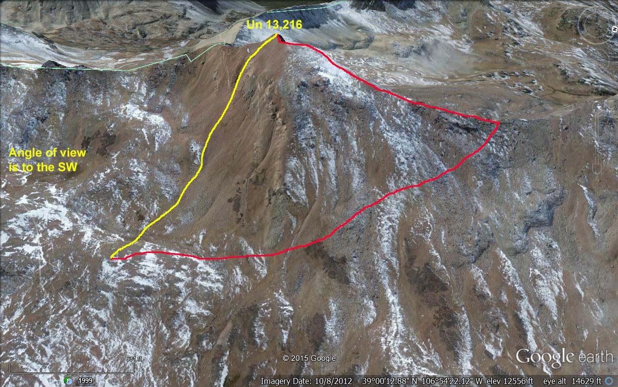
Year Climbed: 2000If following our "approach," which entails backpacking in from Brush Creek past Twin Lakes and over Coffeepot Pass to a high camp about 1 mile SW of Conundrum Hot Springs, then this summit can be completed in just a couple of hours. From a high camp above the hot springs, there are two easy ways to the summit: 1. Hike directly uphill to the west aiming for the summit. This will be the steeper way to gain the summit and will take you over grassy tundra before turning to embedded rocks and rubble near the summit. There will be some rock outcrops to work through by staying in a gully. 2. From the high camp, hike over grassy tundra and some rubble NNW toward a saddle between UN13,214 and UN13,552. At the saddle, turn south and walk along the mostly tundra ridge to the summit. There will be a false summit to go over before coming to the true summit, which is a rock outcrop with a dramatic drop on the west side that makes for some nice photos. going the longer way will make roundtrip mileage about 2 miles. Total elevation gain will be the same either way.
-