LoJ: #110 (Pre-LiDAR #109) / 13,801' UN 13,801 Formerly UN 13,795

Peak Summary
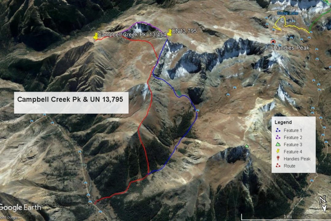
UN 13,795 lies along an eastern ridge of Handies Peak. It can be easily combined with Whitecross Mtn. and Handies for a full circuit day of Grizzly Gulch, but then there's also Campbell Creek Pk. (13,454). We have paired up UN13,795 and Campbell Creek Peak for an interesting day that will avoid the crowds on Handies for much of the day. The trailhead for Grizzly Gulch is best accessed by 4WD with good clearance. We have seen many cross-over, 4WD or All-wheel-drive vehicles up there but some section of the road above Sherman will be challenging without adequate clearance. This hike does not exceed Class 2.
UN13,795 SE to NE Ridge Route
-
-
Grizzly Gulch - Silver Ck TH
From Lake City, proceed south on HWY 149 and take the turnoff to the right (south) for Lake San Cristobal a little over 2 miles out of town and after gaining some elevation. Continue south around the lake on the west side and follow CR3 (BLM 3306; CR30 on Trails Illustrated #141) past the Williams Creek, then the Mill Creek (13.2 miles from Lake City) campgrounds to the road intersection at Sherman. (1.2 miles past the Mill Creek CG) Road to here is passable for standard passenger cars. Take the right fork (known as the Cinnamon Pass Road) and begin a steeper ascent into the upper valley. Higher/better-than-average clearance vehicles now advisable. It's a little over 4 miles to the Silver Creek/Grizzly Gulch trail heads used for accessing Sunshine, Redcloud and Handies. From Lake City, it's about 18.5 miles overall and requires the better part of an hour to make the drive. On the weekends, park wherever you can find a place to squeeze in. There is a small parking area on the north side of the road, and the trail for Sunshine/Redcloud begins from the lot. A vault toilet is on the south side of the road with the trail taking off from behind the toilet and a footbridge takes you over the Lake Fork to access Grizzly Gulch and Handies Peak.
Camping
On the east side of Lake San Cristobal, there are two designated campgrounds. South of the lake, there are two more campgrounds: the Williams Creek and the Mill Creek. These typically fill on the weekends. After Mill Creek CG, there are no more designated campgrounds, but there are other at-large, primitive opportunities. Turn off toward Sherman and you may find a spot or two as you drive toward the Cataract Gulch TH. If you continue on up road 3306 to the trailhead for Grizzly Gulch and Silver Creek, some people camp right at the TH parking or on nearby spots, and there are more at-large spots further up the road, but be careful about private property.
-
From "Campbell Creek Peak"
Open This Route in a New WindowStart out on the convenient and possibly crowded Handies Peak trail that fords the Lake Fork of the Gunnison River on a sturdy bridge. Hike WSW up the trail toward Handies through fairly open forest. About one mile up the trail at an elevation of 11,125 ft., look across Grizzly Gulch to see the three parallel avalanche gullies that descend off Pt. 12,792. Find a way to cross the stream and head up the third (westernmost) gully. You can avoid most willows by clinging to one side or the other of the chute. We utilized mostly the left side where we found numerous game trails. The ascent here is steep but on good footing all the way. Half way up, the gully constricts and then widens back out. At 12,000 ft., you leave the trees behind and walk on open tundra slopes filled with a profusion of July wildflowers. Tag the Pt.12,792 and continue hiking on less steep terrain to Pt. 13,502 over mostly tundra with one short rocky section below that next point.
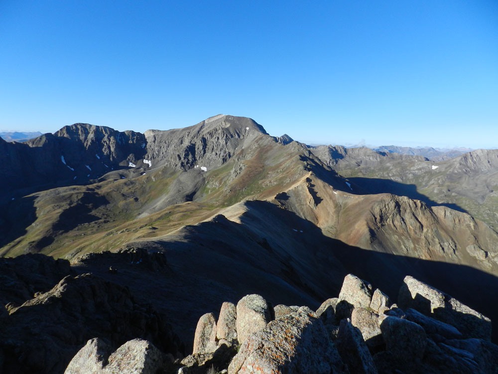
From Pt. 13,502 follow SSW along the ridge, losing some elevation to a saddle below UN13,801. Head off the saddle to the left and take a contouring descent into the head of Campbell Creek, dropping no lower than 12,800 ft. Re-ascend to the west ridge of UN13,454 (Campbell Creek Peak) gaining the ridge at a saddle about 1/2 mile west of the summit but well east of a rocky section of the connecting ridge between UN13,454 and UN13,801. You may find a game trail leading to this saddle. In early to mid season, there may be snowfields to cross. Once on the ridge, follow it ENE the last half mile as it slowly gains to the summit of UN13,454 over a mix of tundra and rock. There's nothing particularly scenic about this rock and tundra summit itself, but it offers a great view looking back down the Lake Fork Valley and surprisingly of the Grenadier Mountains. The drop off into Cottonwood Creek over 3,500 feet below to the south is very impressive.
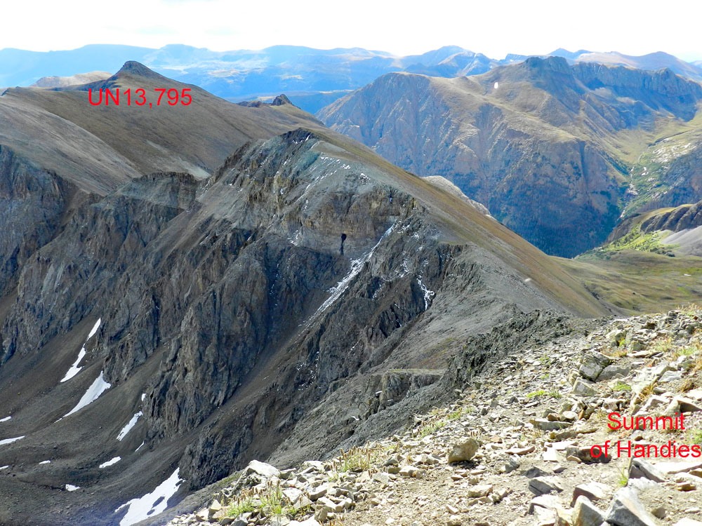
For the return to base, retrace your route back over to the Pt.13,502, unless you are going to include UN13,801 in your plans for the day. If you do, the only real problem will be a short stretch of broken rocks and cliffs about mid way on the connecting ridge between the two summits. There is one deep gash in that section. From UN13,801, you may either descend as you came from Grizzly Creek or see the descent description for UN13,801 for a quick alternate that may save some time and take you by an unusually colored lake.
Click thumbnail to view full-size photo + captionRoute Description
Year Climbed: 1999UN13,795 is sequenced with Campbell Creek Pk. (13,454). One way mileage and elevation gain are measured from the summit of Campbell Creek Pk. Round-trip mileage and elevation gain assume completion of the circuit.
From the summit of Campbell Creek Peak, walk WSW down the ridge to the low-point saddle, then begin regaining some elevation as you continue west. Most all of this ridge traverse is a combination of low tundra, embedded rock and some rubble and scree. A little beyond the low point/saddle, you will encounter a rough, rocky section of ridge. There is one deep gash in that section. The best bypass if you do not want to attempt staying mostly on the ridge crest is to drop down 100 feet on the south side before reaching the difficulty and pick up a game trail that skirts below the outcrops and regains the ridge beyond the problems. The trail can be seen on Google Earth. Once beyond the difficulty, continue now NW to the summit of UN13,795 over similar terrain. If you find the suggested trail bypass on the south side of the ridge difficulty, you cam keep this to a Class 2 hike. If you attempt to follow directly on the ridge, there will be some Class 2+ work at a minimum with perhaps some Class 3 depending on the path you choose.
Once on the summit of UN13,795, you can stroll down the NNE ridge amid game trails back to Pt.13,502. Then descend north along the ridge line at least 100 feet and then turn into a shallow gully filled with small scree/talus that drops down toward the unnamed lake of unusual, turquoise color at 12,323 ft. (This scree slope will offer a very fast descent, but we would not suggest trying to go up it. It would be one of those "two-steps-forward, one-step-back" kind of ascents.) From the small lake, drop back down to Grizzly Gulch, pick up the Handies trail and follow numerous 14er-baggers back out to the trailhead. Round trip time: 6 - 7 hours.
Additional BETA
Links to other information, routes & trip reports for this peak that may be helpful. -