LoJ: #513 (Pre-LiDAR #516) / 13,164' V 5

Peak Summary
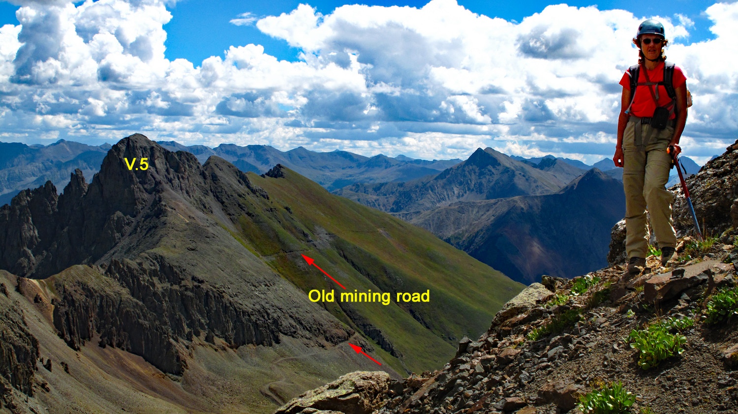
A Class 2 summit most easily done from the Clear Lake Road above the South Mineral Campground. Requires 4WD vehicle access. This summit has just a little bit of scrambling. It's most rewarding feature is its view overlooking Clear Lake and the rugged peaks surrounding it, including the ominous South Lookout Peak. From atop V.5, you'll be able to study the route for South Lookout carefully. If planning on doing S. Lookout, it's worth the climb of V.5 for the information you'll be able to garner from the detailed view of S. Lookout. LoJ gives this summit a Class 2+ rating. Not sure why. We did not feel it held enough difficulty to merit the "+". Lidar added 8 feet of elevation.
V5 South Slopes Route
-
-
South Mineral CK. - Clear Lake TH
Use this trailhead description for climbing S. Lookout Peak; V.5 or possibly V. 2 as an alternate route.
From the Town of Silverton and the US 550 intersection on the west side of town, drive north on US 550 and in a little over 2 miles turn west onto FR585. If coming from Ouray, drive south on US 550 over Red Mountain Pass and watch for the FR585 turnoff on your right before reaching Silverton. Drive west on this graded dirt road to the campground and trailhead parking appx. 4.7 miles in. The last mile of road gets a little rougher but should still be navigable by passenger cars.
To reach Clear Lake and the Clear Lake FR815, at 4.2 miles in on FR585 after turning off US550, there's a single-track road that veers off to the right at these coordinates: N 37° 48' 19.42" W 107° 46' 25.33". Elevation is 9,795 ft. The road is best suited for 4WD with good clearance. This is known as the "Clear Lake Road" and actually continues all the way to Clear Lake. The road does not show on the USGS 1955 quad. The road has a lot of switchbacks. On the lower section, there are eight. #7 is not so much a switchback as it is a broader turn that still mostly reverses direction. Above these 8, when you break out of the forest, there are four more to gain the final elevation needed to reach Clear Lake. There is limited camping at switchbacks #6,7 & 8. Otherwise, go all the way to the lake at elevation 11,985 in the parking lot for a more frigid overnight stay.
Camping
All along FR585, once you turn off US550, there are numerous at-large, primitive sites. Upon turning off US 550 and driving less than a mile, there's a large open area on the left with a vault toilet. There are usually a large number of RV's here. There is also the South Mineral Creek Campground and before arriving at the campground, you will see a number of other camp spots. Expect fierce competition on summer weekends for sites. This is a very popular area. There is no "allowed" camping at the trail head parking area.Directions for South Mineral CG per San Juan NF: South Mineral Campground is accessed by turning off U.S. Highway 550, about 3 miles west of Silverton, onto Forest Rd. 585, which heads west along South Mineral Creek. The campground is 4 miles off the highway and has 26 mostly level sites. Several camping loops and well-spaced sites are mostly shaded, but some are sunny. A few are next to the creek, and some have large parking areas. The Ice Lake Basin Trail, a strenuous, steep, and popular hike, begins across the road from the campground. It leads up above timberline to high alpine lakes surrounded by meadows of wildflowers and rocky peaks. South Mineral Campground does not take reservations. All sites are first come first served. There are an assortment of designated areas along South Mineral Road where dispersed camping is allowed so there is plenty of camping in the canyon on all but the busiest days.Picnic tables, composting vault toilets, fire grates, trash disposal, potable water. No electricity. Operated by concessionaire. The campground has 26 sites that are mostly level, at 9,800 feet. Some sites are handicapped accessible. Several camping loops and well-spaced sites offer plenty of privacy. Spruce and fir give lots of shade, but there are some sunny sites. A few sites are along the creek, and some have large parking areas.Dispersed camping along Forest Rd. 585 is allowed only in designated camping areas. Please follow posted directions and instructions.
Campsite Locations
South Mineral › N 37° 48' 23.52', W 107° 46' 25.33"Elevation 9,855 ft.
Click thumbnail to view full-size photo + captionRoute Description
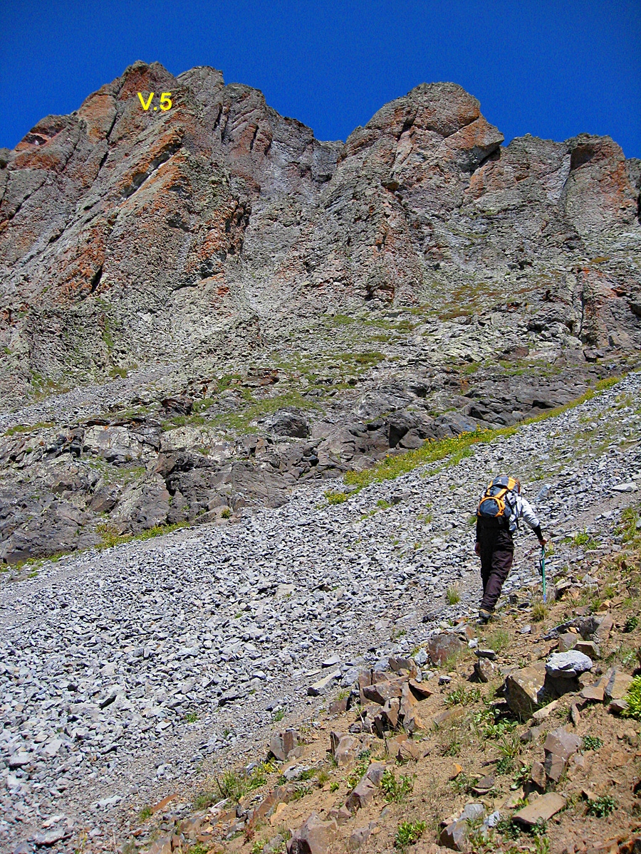
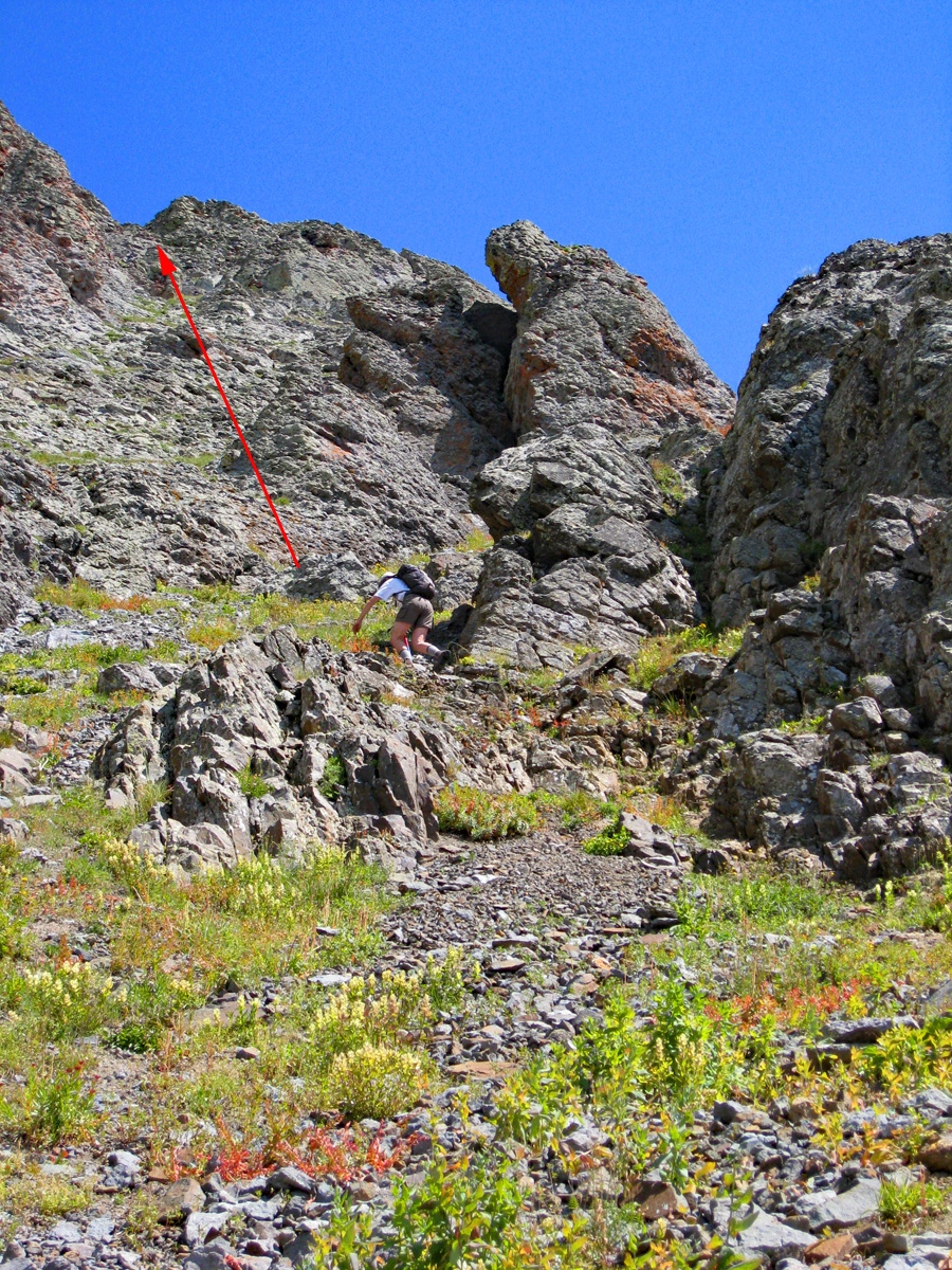
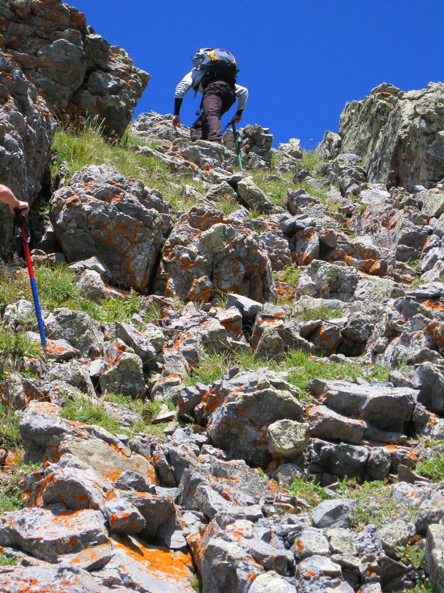
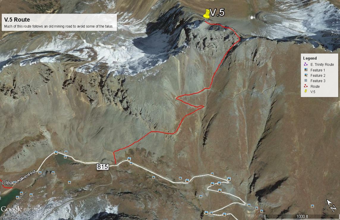
Year Climbed: 2007From a parking spot below Clear Lake, where the road just begins to lose altitude, an old mining road leads up the mountainside. Follow it whenever you want to help avoid some of the boulder talus. For the most part, tundra-covered slopes allow for more direct access without using the road but you will need to do some upward contouring to avoid getting sucked into some of the talus. Higher up on the southwest face of the peak, we left the old roadbed and hiked up a very prominent couloir that splits the summit ridge. Where this couloir forks, take the right hand branch and continue ascending on steep and loose, broken rock until you come near the head of that couloir. Just below the head, turn left and follow a path through a break in the rock and cross the head of another branch of the couloir. Ascend directly up the rock & tundra ledges for a short bit before heading over to another upper branch of the couloir that will lead out and to the summit ridge. From this ridge location, the rocky, rounded summit is just a few minutes away. The summit affords an outstanding view of South Lookout.
It only required about an hour to climb to the summit and the descent was even faster. While our South Lookout climb had taken about three hours to complete, this peak only takes about 2. We utilized more of the road going down, but most of this southwest face of V.5 is tundra covered, but steep and you can descend directly for much of it. Again, wildflowers would be rampant here in the middle of summer.
Additional BETA
Links to other information, routes & trip reports for this peak that may be helpful. -