LoJ: #260 (Pre-LiDAR: NR) / 13,495' Chipeta Mountain
Peak Summary
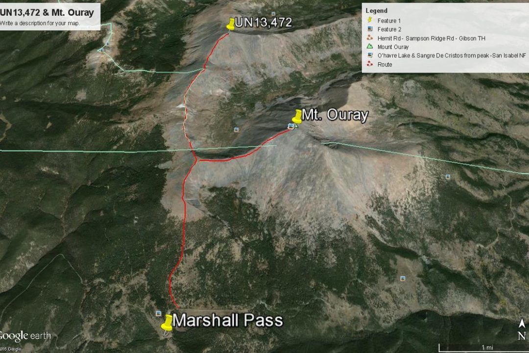
Note: On the USGS map, the name "Chipeta Mountain" is printed alongside Pt. 12,850. Since the point north of thta is 13,472, the name Chipeta has also been associated with it since that would be the highest point of Chipeta Mountain. An easy Class 2 hike of about 8 miles total from the top of Marshall Pass. Accessible by most vehicles, this climb gets you into some country you won't visit too often if you're a peakbagger. Combines with Mount Ouray, a top 100 summit, which would add about 3 more miles to your day. Lidar measurements added 23 feet of elevation to this summit bumping it up in the rankings substantially.
Chipeta Mountain South Ridge Route
-
-
Marshall Pass TH
The trailhead is basically the summit of Marshall Pass. Just on the east side of the pass, less than .2 mile down, there's a fairly large parking area where the road curves back from the north to the east. This is used primarily to access the shared Continental Divide & Colorado Trail and for ATV's. To get there from Gunnison, drive east on US50 to Sargents and turn right (SE) onto the Marshall Pass Road (CR243) which further up is FR243 and rated passable for passenger cars. At a major intersection about 5 miles in, be sure and stay right and continue on 243 to the pass which is about 16.5 long miles total. This road follows an old railroad bed so it never climbs steeply and to gain elevation, it seemingly winds all around to gain the pass.
If coming from the Front Range, find you way to Poncha Springs where US285 and US50 intersect. Continue south on US285 and turn off to the right (SW) onto CR200 at Mears Junction (also labeled the Marshall Pass Road). If you have come to the summit of Poncha Pass, you've missed the turnoff. Turn around and go back about 2.4 miles. Follow the old railroad bed all the way to Marshall Pass. About 2.4 miles in, you'll need to make a right turn and less than a mile further, another right at a four-way junction in order to continue on course & FR200 to O'Haver Lake and eventually Marshall Pass. It's a little over 14 miles from the highway. To reach the actual pass summit, you would have just driven by the parking area mentioned above. CR200 is also rated passable for passenger cars as well.
Camping
On both sides of Marshall Pass and especially in the vicinity of the pass you can find at-large, primitive campsites. On the east side of the pass, there's a fee-type, National Forest campground at O'Haver Lake.
Route Description
Year Climbed: 1999Note: On the USGS quad, the name "Chipeta Mountain" appears next to Pt. 12,850. Since the unnamed summit of 13,472 north of that point is higher, the name Chipeta Mountain has been applied to UN 13,472.
From Marshall Pass, if you're just climbing Chipeta you could head north on the shared Continental Divide/Colorado Trail until you're due west of Chipeta Mountain/Pt. 12,850. Then you could easily ascend the west facing slopes of it, turn north from that summit and make the final ascent to UN13,472/Chipeta. This route would have the convenience of a well-maintained trail for several miles, but being the peakbaggers that we are, we prefer the higher elevations and the views.
So again, from Marshall Pass, walk north along the road until it begins to turn to the east and utilize trail if you want or head north into meadows with open forest to gain the broad south ridge that comes off Pt. 12,685. There is a short road that leads to a private cabin near here. If you stay more to the east side of this south slope/ridge, you can avoid denser forest and follow up on mostly open grass & tundra with open trees all about. The goal would be to gain the ridge where it forms up and becomes more pronounced south of PT. 12,685. On Google Earth you can even spot a trail now that goes all the way up to the ridge and beyond. Once on the ridge, the now more defined trail generally stays just on the west side, but at one point, goes off on the east side to avoid an area of rocks. The trail leads to the top of PT.12,685 where it then turns east for Mount Ouray. If not climbing Ouray and only heading for 13,472/Chipeta,, it may be tempting to contour below Pt. 12,685 on the west side to avoid unnecessary elevation gain & loss, however, you'll find a tedious contour across boulders. It's easier to just stay on the ridge crest.
From Pt. 12,685, proceed north following the ridge crest over two minor rises and three minor saddle to Chipeta Mountain/12,850. Drop a final time about 200 feet to another saddle and then make the final walking ascent to 13,472/Chipeta. Almost all the hike to this last saddle from PT.12,685 is over tundra or embedded rock and minor talus. The last stretch is mostly rocky rubble. All along this high traverse, you'll be looking down into the remote upper end of Little Cochetopa Creek. If you're lucky, you may be able to spot some elk. On our particular climb, we spotted some bighorn sheep. We also watched a flock of about 100 crows flying all around the this peak on the thermals. We had never before seen quite so many congregated together.
The hike to this summit from the pass took us about 4 hours. The return won't be much shorter because there's so much high ridge to navigate back across, assuming you go back as you came. It would also be possible to bail off the ridge at Chipeta and drop west to pick up the Continental Divide/Colorado Trail below. This might be advisable if the weather becomes threatening.
-