LoJ: #218 (Pre-LiDAR #S/R) / 13,556' UN 13556 "Independence Peak" Formerly UN 13,545
Peak Summary
Newly added in 2022 from previous soft-rank status by LIDAR technology, this summit has two basic approaches from the west side and Independence Lake or the east side following the Lake Fork. From the west side, it's a minimum Class 2+ on difficult, steep, gravel and rock terrain. On our ascent, it became brief Class 3 near the summit. The east side approach can be kept at Class 2 but requires a few more miles hiking.
UN 13556 East Flank Route
-
-
North Fork Lake Creek TH
From Aspen, drive east on SH82 over the summit of Independence Pass and continue down the east side of the pass to the last switchback where the highway drops into the North Lake Creek valley. Just below the last switchback, there's a turnoff to the left (east) that's a short dirt road that leads to trailhead parking for several vehicles in 100 yards or so. This is just under 5 miles from the summit of the pass. The trailhead parking has a wood rail fence. The short drive in may have some potholes.
If coming from the Front Range, turn west from US24 onto SH82 and drive west past Twin Lakes, continuing up along the Lake Fork until the highway makes the first switchback to begin the climb up Independence Pass. Just before that switchback, turn right (east) onto the dirt road that leads to the trailhead parking in 100 yards or so. This measures about 18.5 miles from US24/SH82 turnoff.
Camping
Camping at the trailhead parking area is not good. If you can get your vehicle across the creek here, there's a faded track that leads up to a primitive site in some trees. Otherwise, there are designated National Forest campgrounds at Parry Peak and Twin Peaks campgrounds back towards Twin Lakes. We recommend a primitive site that has numerous camping possibilities about 2.4 miles back south on SH82 from the trailhead where a diversion tunnel empties water into the Lake Creek at these coordinates: N 39° 04' 54.99" W 106° 32' 21.86". We call this the Graham Gulch TH and it's 16.1 miles from US24/SH82. About a half mile north of there is another smaller area on the west side of the highway at these coordinates: N 39° 05' 15.72" W 106° 32' 32.28".
Measuring from the US24/SH82 intersection, the Whitaker CG is 5.3 miles; Town of Twin Lakes is 6.1; Willis Gulch TH is 8.1; Parry Peak CG is 8.7; Twin Peaks is 9.4; La Plata Peak TH is 14.0.
Campsite Locations
Graham Gulch › N 39° 04' 54.99", W 106° 32' 21.86"
Route Description
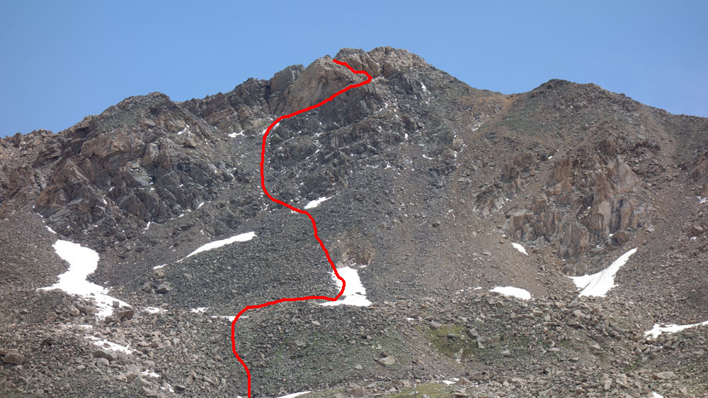
Year Climbed: 2022From the North Fork Lake Creek trailhead, take the main trail that heads north, staying on the west side of the main creek. Hike an easy 2.25 miles north to the last group of trees on the left, that are on a hillside overlooking the main creek. If you notice a trail crossing over to the east side of the creek, ignore it and work your way through the willows to these approximate coordinates: N 39° 08' 47.13" W 106° 32' 27.50". Depart the trail and begin working NNW, contouring up towards the trees and an open area on the north end of the main group of trees that has some tundra, willows and larger rocks. Work west up that opening heading generally toward Pt. 12,273 - a rockier outcrop on a sub-ridge. Once past the trees and the worst willows, head for a saddle just a little west of Pt. 12,273, cross that saddle and contour over WNW into the next shallow drainage. Head up the drainage and study the eastern flan of UN 13556 for the best route. The more direct path to the summit will be steeper and rockier. You can utilize tundra more by swinging left and making a more indirect, wider arc to gain the east flank before turning more north for the summit. The summit itself is mostly larger embedded rocks with some tundra mixed in. From the summit, you can enjoy a nice view of Independence Lake on the west side and of the headwaters of the North Fork of Lake Creek. The view includes two other 13ers; #466 UN13220 (formerly UN 13202) and #408 UN13291 (formerly UN13300) to the northeast, and of course, Deer Mountain and Mt. Champion across the valley.
Additional BETA
Links to other information, routes & trip reports for this peak that may be helpful. -