LoJ: #266 (Pre-LiDAR #264) / 13,492' Cuatro Peak
Range ›
Sangre de Cristo Range
Quadrangle ›
Trinchera Peak
Summit Location ›
 N 37° 15' 30.53", W 105° 09' 16.74"
(Not Field Checked)
N 37° 15' 30.53", W 105° 09' 16.74"
(Not Field Checked)
Neighboring Peaks ›
Mount Maxwell
Trinchera Peak
"Leaning South Peak" [Formerly UN13203]
Peak Summary
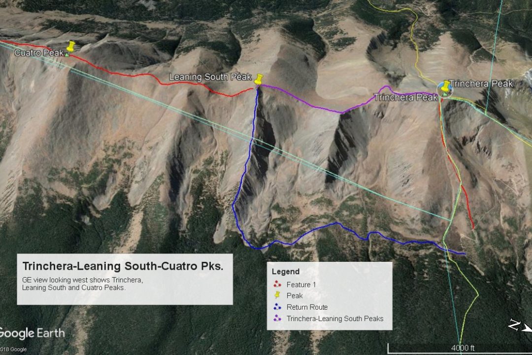
Cuatro Peak is an opportunity to see a section of the state near Cucharas Pass that you may seldom visit and offers some easy and pleasant hiking at Class 1 to Class 2. We have sequenced Cuatro with Trinchera and Leaning South Peak. Mt. Maxwell, (which is unranked) can also be included in a longer day. The proposed trailhead for the sequence is passenger car accessible. There is another access which requires 4WD. Lidar added 5 feet of elevation.
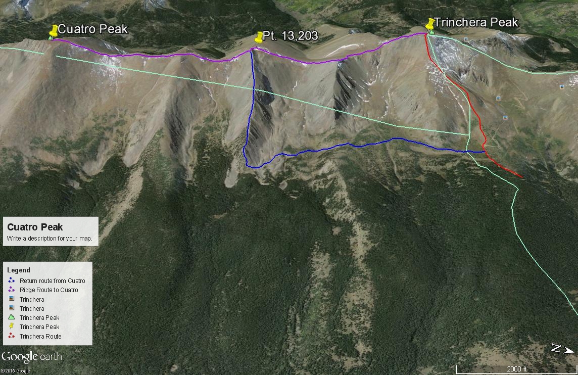
Cuatro Peak North Ridge Route
Class 2
RT From Blue Lakes Trailhead - Trinchera/Cuatro:
12.3 mi / 4,355'
RT From
4WD Parking on FR436 @ 11,650
with
Trinchera Peak+"Formerly UN13203":
7.9 mi / 3,255'
From "Formerly UN13203":
1.30 mi / 680' (One-Way)
-
-
Blue Lakes Trailhead - Trinchera/Cuatro
This trailhead would be primarily used for access to Trinchera and Cuatro summits, (and also "English Saddle," a high 12er north of Trinchera). From Walsenburg, drive west on US 160 and take the turnoff for La Veta, on SH12. Drive through the quaint, small town and continue south toward Cucharas Pass. This very pleasant road takes you through gambel oak terrain, into ponderosa forest and eventually more typical higher elevation aspen and conifers. If you do road bicycling, this is a great ride! Drive on through the little townsite of Cuchara, past the turnoff for the old Cuchara Valley Ski area and just under 2 miles before reaching the summit of Cucharas Pass, turn west (right) onto FR422 and drive the steep, graded dirt road to the Blue Lakes Campground. There is no sign for this turnoff, but it comes just before the highway makes a sharp left curve. As you drive up FR422, there is no "official" camping but there are some picnic areas. It's about 4 miles to the Blue Lake CG. At the 4-way intersection where you can turn down into the campground, turn left onto FR436. Drive a few yards and find a place to park if in a passenger car. Or, you might inquire with the campground host to see if there's a better parking option.
From Alamosa, drive east on US160 through Ft. Garland and over La Veta Pass. About 15 miles east of the pass, watch for the SH12 turnoff to the town of La Veta. Follow the directions as above.If you have a map, there is a good short-cut option on CR450 that will save several miles of backtracking.
For another longer but possible access to Trinchera & Cuatro, see the trailhead titled "Mt. Maxwell Trailhead." This access could also be used to reach summits like Mariquita and De Anza B.
If you have 4WD with good clearance, it's possible to drive on up FR436 to timberline or above. It's a slow 2.2 miles to a small but good campsite at the last trees. The road is in worse shape in 2019 than when we last drove it 10 years before. Along the first .4 mile, there are several (4?) designated, primitive, no-fee campsites. The road is slow going up to the "North Fork TH" at 1.3 miles up. There are sharp switchbacks, it's narrow and quite rocky, but we got our Toyota Tundra with a 6.5 ft. bed up it okay. Though rocky, there were no major clearance problems. There are numerous berms as well to divert runoff. The next .8 mile to a couple of campsite locations is less rocky and a little better condition. Beyond treeline it gets quite rough.
Camping
There are two designated, Forest Service campgrounds; the Blue Lakes and the Bear Lake, just a mile beyond Blue Lakes. Both are accessible by passenger cars. Both have vault toilets but no water. Campground host available at both and firewood for sale. Blue Lake CG has 14 - 16 sites and mostly forested. Bear Lake has 14 sites, some of which are more in open meadow. Just a short distance up FR436 from the Blue Lakes CG, there are 4? primitive spots if the FS has not closed them. Further up FS436, if you have 4WD, there are more primitive sites. See coordinates below. There is not any good level spot to camp at the North Fork TH.
Campsite Locations
Campsite 1 › N 37° 17' 42.74", W 105° 09' 02.91"Elevation 11,770 ft. Some slope but you can find a good tent spot.Campsite 2 › N 37° 17' 40.35", W 105° 09' 06.78"Elevation 11,835 ft. Small site with parking for one vehicle, or possibly two. last trees.
-
From Blue Lakes - Trinchera/Cuatro TH via 4WD Parking on FR436 @ 11,650 & "Formerly UN13203":
-
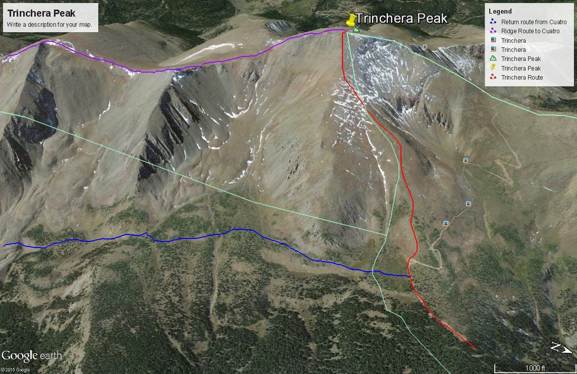
Trinchera Peak NE Ridge Class 1 / 1.25 mi / 1,860’ One-Way
Click thumbnail to view full-size photo + caption
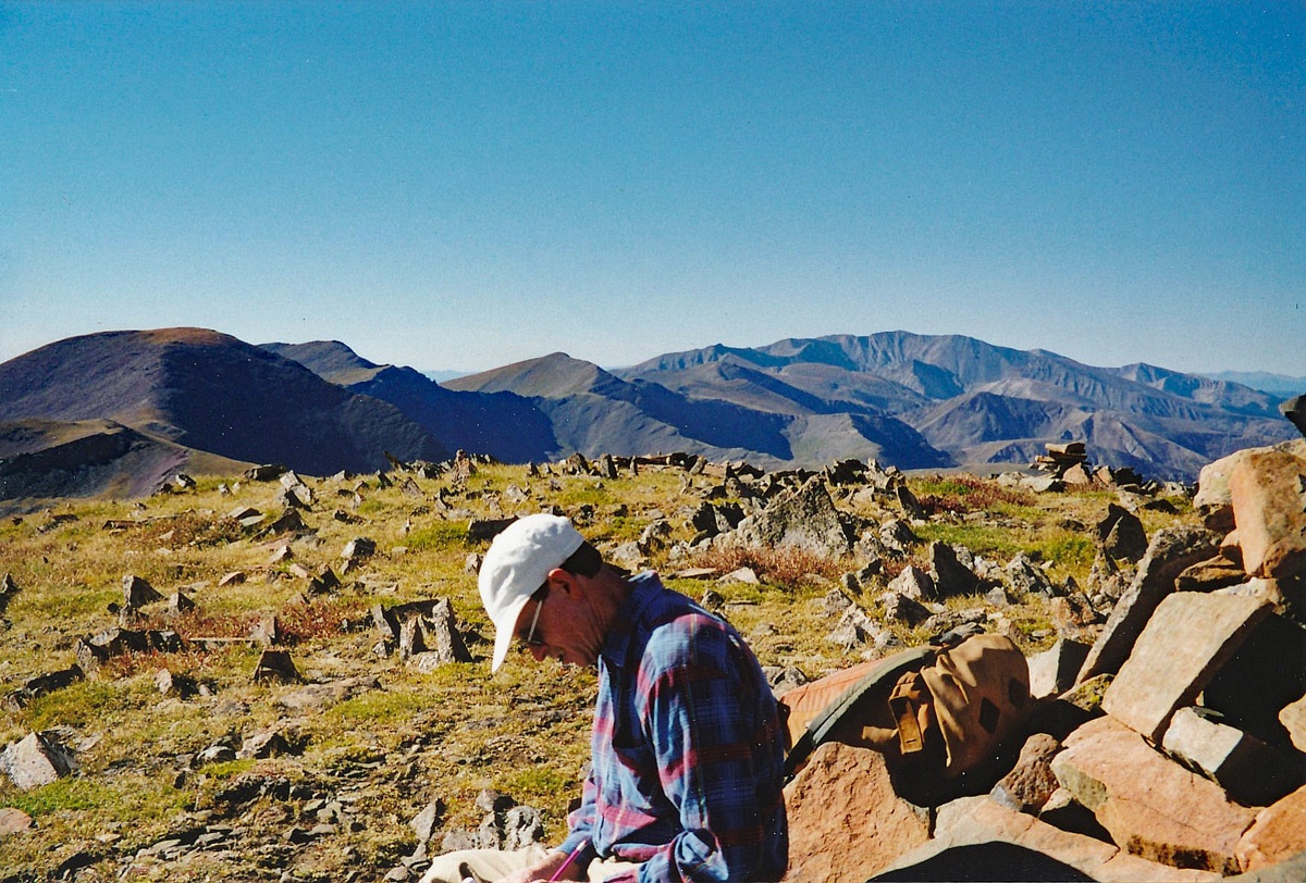
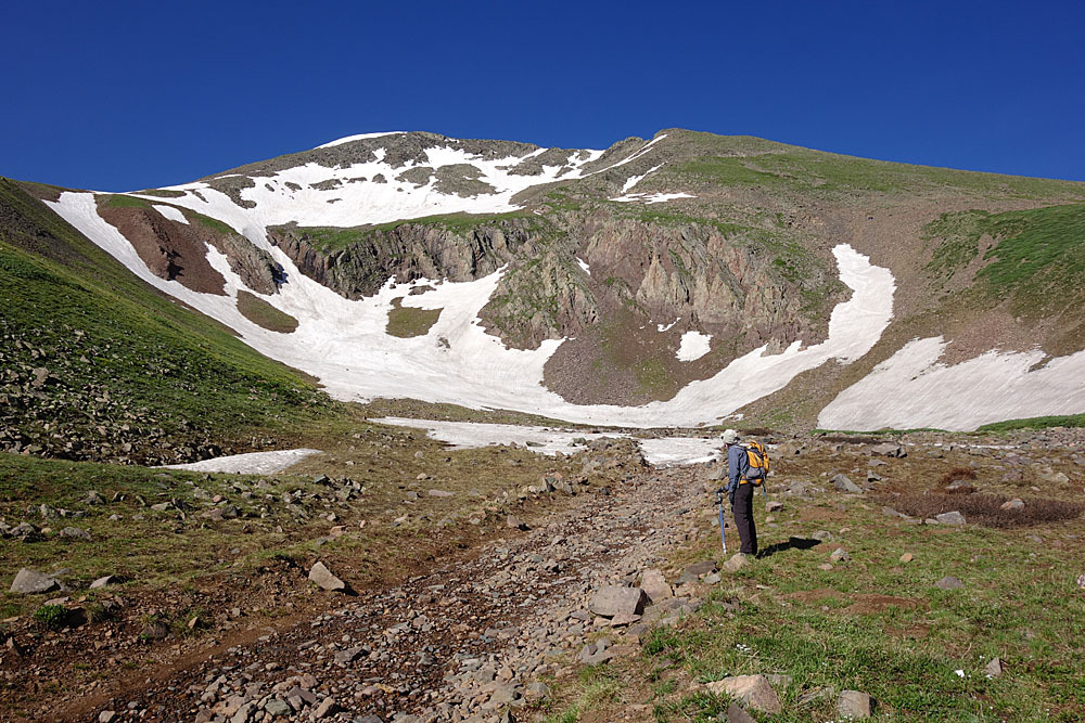
Open This Route in a New WindowIf you've followed FS436 to tree line at 11,660 feet., continue following the same road up the first two switchbacks and then depart the road and begin hiking up the fairly broad NE ridge or Trinchera. You could keep following the road, but it leads to a pass directly north of the summit and a steeper ridge climb. The hike up the NE ridge is easy on tundra for much of the way with typical embedded rocks. The last few hundred feet steepen and become more rocky for the summit finish. When you arrive at the summit, if the winds are blowing too hard (not a surprise for this range) you can hide behind some of the large cairns. The summit view offers a panorama of surrounding great valleys, plains and forest, with rolling, mostly gentle mountains that stretch into New Mexico. Watch for wildlife - particularly herds of elk and bighorn sheep which we saw twice.
Once you arrive at the summit of Trinchera, it would make little sense to not go ahead and include Leaning South Peak and Cuatro Peak, about 2.6 miles south along the central ridge, in your plans for the day. The ridge walk is easy. Mt. Maxwell could also be included, but it is unranked.
Bonus Points: Another option to consider is to summit UN12,955, about one mile north of Trinchera. The descent off Trinchera north may involve a little bit of Class 3 work at a notch along with more difficult Class 2+ talus & rubble according to a report on LoJ by "Furthermore."
-
Leaning South Pk North Ridge Class 2 / 1.35 mi / 565’ One-Way
Open This Route in a New WindowUN 13,218 (aka: Leaning South Peak) is sequenced with Trinchera Peak and Cuatro Peak. One-way mileage and elevation gain are measured from the summit of Trinchera Peak. Round-trip mileage and elevation gain assume completion of the entire sequence. The direction of the sequenced route progresses from north to south.
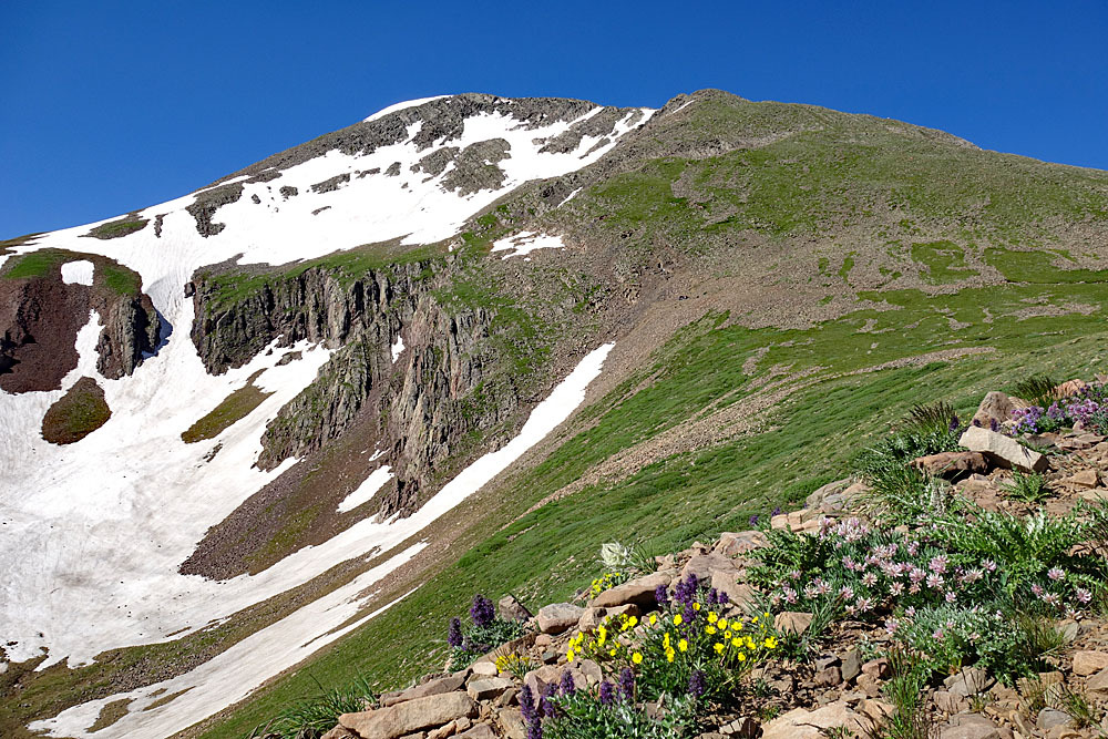
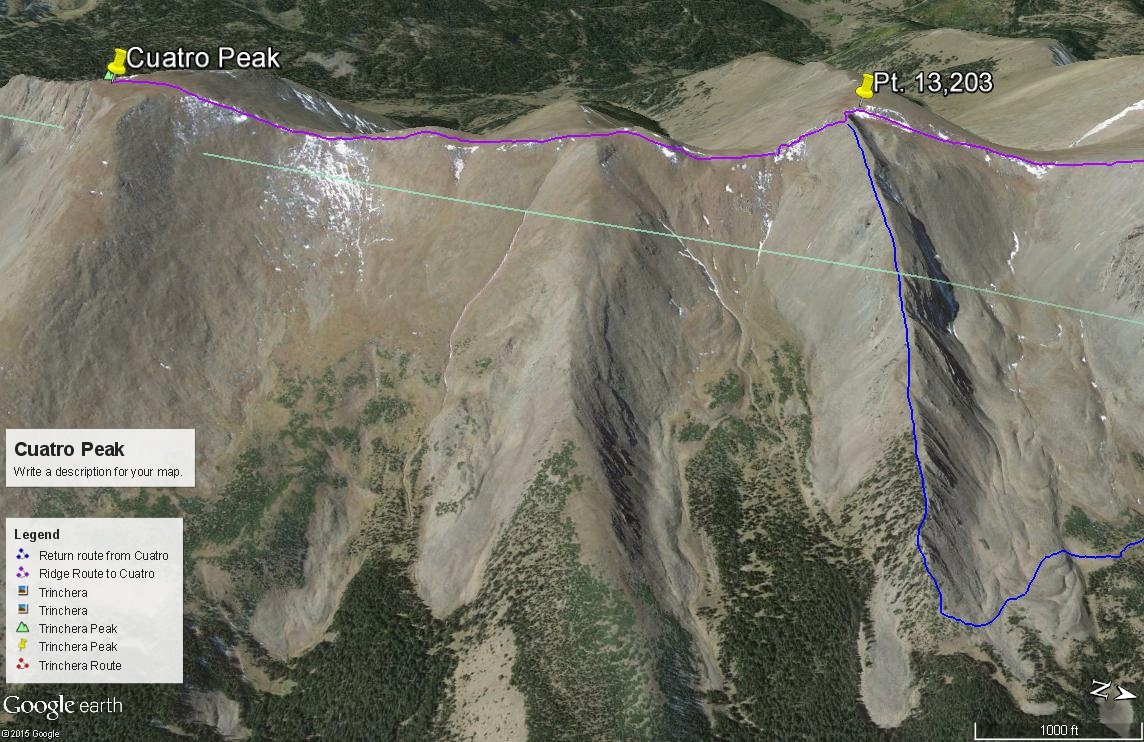
From the summit of Trinchera Peak, walk south, descending to a minor bump at 13,250 ft. Turn SE and head down to a saddle followed by another short uphill walk to an unmeasured point, (13,120 ft. appx.) gaining about 140 vertical feet. Turn directly south again, drop to yet another saddle, then make the final 425 feet of gain to the summit of Leaning South Peak. There is a game trail that can be taken to avoid the 13,120 point which contours on the west side and leads over to the next saddle. The entire walk from Trinchera is on tundra, tundra with embedded rock and some minor swaths of rubble. This is a pleasant, high ridge walk. Keep your eye out for game, especially elk and bighorn sheep. We suggest continuing south from here to Cuatro Peak, however, our descent route begins here on the summit of Leaning South Peak. So if you go to Cuatro, you may be returning to this summit to commence the descent.
-
Click thumbnail to view full-size photo + captionRoute Description
Year Climbed: 2000Note: When we did Cuatro peak, we started out going up Trinchera first and then following the central ridge south to the summit of Cuatro, passing over the ranked "Leaning South Peak."Cuatro is sequenced with Trinchera, then Leaning South Peak. One-way mileage and elevation gain are measured from the summit of Leaning South Peak. Round-trip mileage and elevation gain assume completion of the sequence. This route description begins from the summit of Leaning South Peak Peak. Consult that peak for both "Approach" and route.
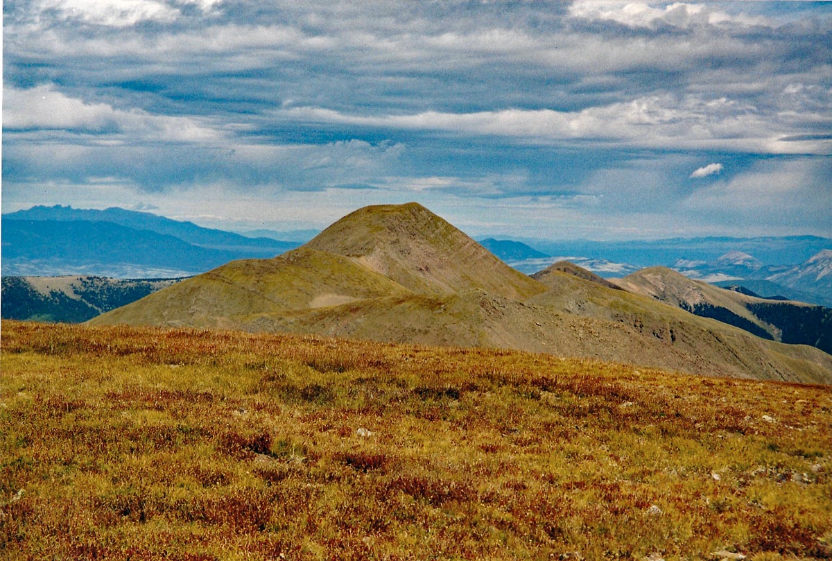
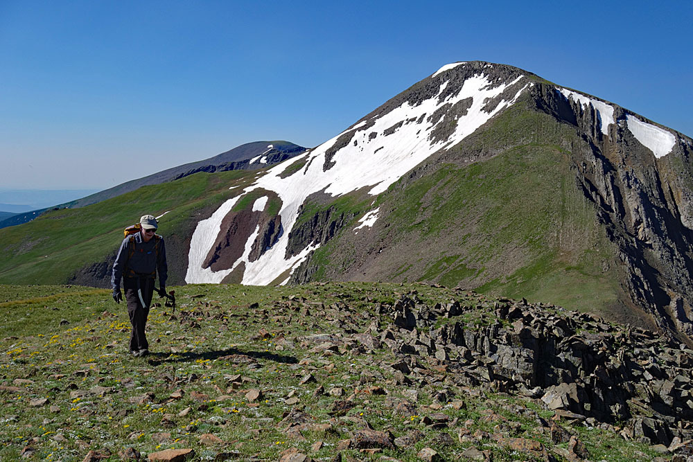
From "Leaning South Peak," once again, lose over 200 feet in elevation to another saddle as you keep walking south. Skirt or walk directly over Pt.13,134, regaining some elevation, drop to the next saddle and then make the final 500 foot ascent to Cuatro Peak. Almost all of this terrain is on easy-going tundra with embedded rocks and some occasional exposed rocky rubble. There are no difficulties to overcome other than the knobby summit of Cuatro. Enjoy the vistas. The next point south, (13,335) is unranked Mt. Maxwell. South of that summit, you're off national forest land and onto private property.
To return: We hiked back north to Pt.13,203 (Leaning South Peak) and then headed directly down the well-defined east ridge dropping to 11,800 feet before exiting the ridge to the north and entering a large basin. There was some talus to work our way through with some extra ups and downs as we worked our way north into the next basin labeled as the "North Fork Purgatoire River." Staying fairly high to avoid willows as best we could, we came out within a quarter mile of our vehicle parked at just above 11,600 feet on the access 4WD road. Be prepared for some willow-bashing on this last section. It is mainly the difficulties of the return that compels us to rate Cuatro and this sequence as Class 2 in stead of a Class 1.
Additional BETA
Links to other information, routes & trip reports for this peak that may be helpful. -

“Don’t limit your challenges; Challenge your limits.” Jerry Dunn
Warning!
Climbing peaks can be dangerous! By using this site and the information contained herein, you're agreeing to use common sense, good judgement, and to not hold us liable nor sue us for any reason. Legal Notice & Terms of Use.