#75 / 13,872' Cronin Peak Formerly: UN 13,870
Peak Summary
Note: At one time, some may have identified this as "North Carbonate." Cronin is named after Mary Cronin, who is reportedly the first woman to have climbed all of Colorado's 14ers, having completed that task in 1934. She was also only the 4th person known to have done so. The current name was approved by the USGS in 2005, so you will find very few maps that acknowledge it.
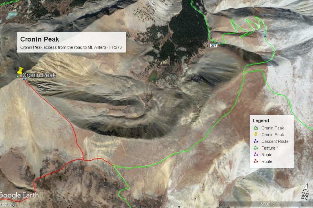
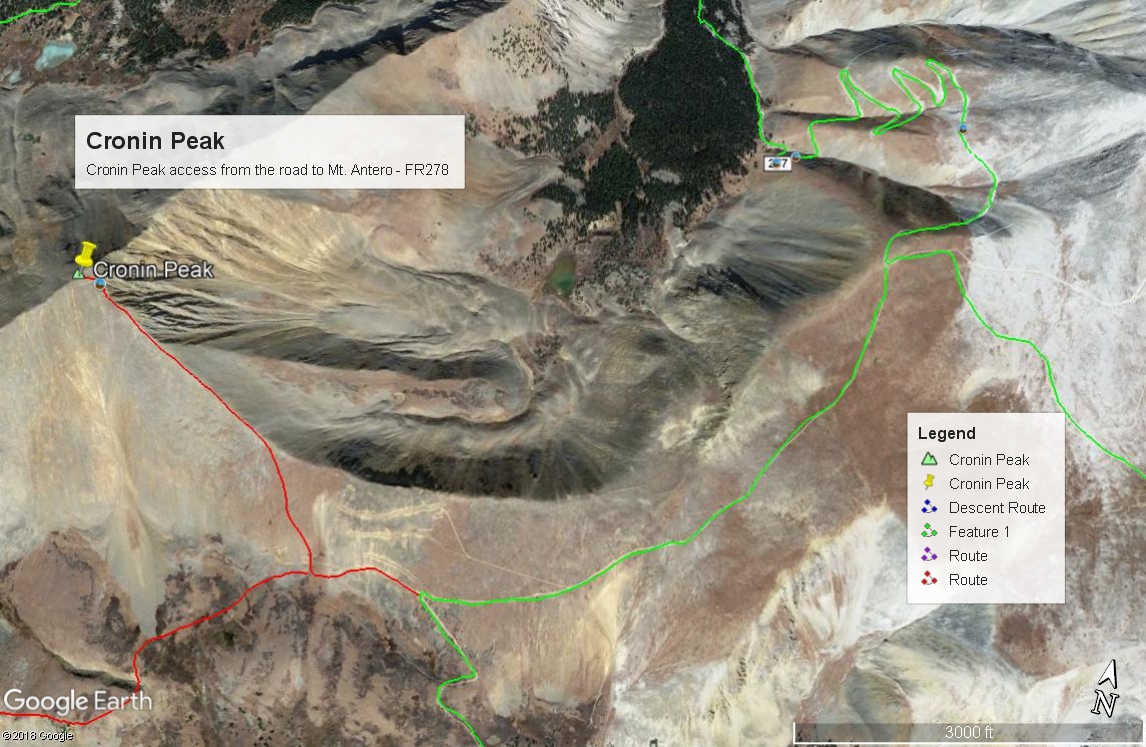
Cronin Peak is a nickname for UN 13,872, per LIDAR, (formerly UN 13,870/North Carbonate), a Class 2 summit which lies WSW of the 14er - Mt. Antero. This summit is easily accessible by way of its ESE ridge if you have a vehicle capable of making it up FR278 which is the road up Mt. Antero. That tedious road is best tackled with a shorter-bed, higher clearance 4WD vehicle. You can park around 12,700 feet to begin the hike. For those who either want to make the hike more sporting or who don't want to abuse their vehicle on FR278, another alternative is to drive the three miles from the lower, Baldwin Creek trailhead to the FR277/FR278 junction, park and hike the NNE ridge of Cronin, which still has a Class 2 rating, but is rockier. Either way requires a higher clearance vehicle at a minimum. It's also possible to walk from the Baldwin Creek lower TH, but this will add six miles round-trip to the day.
Cronin Peak ESE Ridge Route
-
-
Baldwin Creek TH
From the center of town in Buena Vista at the US285 and CR306 intersection, drive south 8.1 miles south on US285 and turn right onto CR162. If coming from Johnson's Corner, drive south 5.7 miles to CR162. This is also known as "Chalk Creek Drive" and heads up towards the Mt. Princeton Hot Springs and takes you below the spectacular Mt. Princeton Chalk cliffs. Drive west on this road for 12.5 miles to the townsite of Alpine. Or measure from the end of the pavement 2.0 miles. Across from Alpine Reservoir is the turnoff for FR277 that heads up Baldwin Creek. There is very limited parking here. You may be able to find some parking around Alpine, but most everything is private property, so be careful where you park. Summer of 2019, we noticed a lot of vehicles parked along the road both before & after the trailhead.
It is possible to drive up the Baldwin Creek road if you have 4WD or 2WD with very good clearance. Every time we've been on this road (and that's quite a few), we have found it tediously rocky and slow and with more and more 4WD's, ATV's, etc., it is not likely to improve. We were last here summer of 2019 and took a quick look at the road condition. Personally - we would not advise going up this road any longer unless you have 4WD with excellent clearance. That said, we did notice signs indicating that some actual work (road repair) was going on, so perhaps there will be some improvements. This trailhead will be somewhat unique in having an "Upper Trailhead" as well. This is where FR277 and FR278 split with FR278 heading off to the left (SE) and immediately crossing Baldwin Creek. FR278 heads up onto Mt. Antero and eventually crosses over into Browns Creek. FR277 continues SW up along Baldwin Creek to a switchback where a trail to Baldwin Lake heads off. Trails Illustrated shows the road ending there now as does the Forest Service map. The coordinates for the FR277/FR278 intersection are N 38° 40' 57.11 W 106° 16' 22.56". Elevation there is 10,870 ft. The distance from the lower TH is 3.0 miles.
Camping
At-large camping opportunities along CR162 are very limited, mainly because of all the private property. There are National Forest, fee-based campgrounds along the way. They are: "Boot Leg" at 8,400ft. with 6 units & no water; Mt. Princeton at 8,000 ft. with 17 units; Chalk Lake at 8,700 ft. with 21 units and past the Baldwin Creek road and up toward St. Elmo, the Iron City CG at 9,900 ft. You can expect all of these to fill up on weekends. This road leading up to St. Elmo is a popular weekend destination for all types of recreationists.
Near the FR277/FR278 intersection, there are some limited, primitive camping opportunities. Drive just a short distance farther on FR277 toward Baldwin Lake and there is a good area with multiple campsites at the coordinates provided below. There are also some good primitive sites on FR278 just after crossing Baldwin Creek.
Campsite Locations
Baldwin Creek › N 38° 40' 50.08", W 106° 16' 29.15"Elevation 10,900 ft.Iron City › N 38° 42' 30.17", W 106° 20' 12.41"Elevation 9,900 ft. Turnoff is along the short stretch of road that leads down to St. Elmo. This campground has 15 sites, one vault toilet and an untreated water pump that we could not get to work.
Route Description
Year Climbed: 1988This most difficult aspect of this route description will be the drive up FR278 on the west side of Mt. Antero. From the intersection of FR277 & FR278, head SSE on 278 continuing up through forest until you reach the last trees at just above 12,000 ft. The road turns east and heads briefly up a gully before making the first of six sharp switchbacks to gain elevation on the flank of Antero. After the sixth switchback, the road heads generally south and crosses a ridge at 13,100 ft. This switchback section of the road is the roughest and most tedious part of the drive (or hike). If hiking this section, attempts to shortcut the switchbacks will lead to frustrating loose rock conditions on a very steep mountainside.
At the ridge crossing at 13,100 ft., there is a fork in the road. Going left grants access to Antero and Mount White. Stay right for Cronin. The ruggedness of the road relents and cuts downhill to the SW through tundra to an intersection at 12,670 feet where you can pull off and begin a hike for Cronin, if you've managed to drive this far. Another option is to lose another 200 feet in elevation and part at a switchback at these coordinates: N 38° 39' 01.02" W 106° 16' 15.04". Elevation is 12,460 ft. At either location, each has a road that leads west and cuts across a large area of talus, with several other short-distance roads from mining efforts that cut through the same talus. Regardless of which you use, cross the talus area west and get back onto some tundra. Turn more to the north and hike up the tundra to Cronin's ESE ridge. Not far up the ridge, conditions will turn to mostly rubble/chiprock/scree. Since the ridge is not too steep, footing is not too bad. Follow the ridge to Cronin's rocky summit. If you can drive to either of the suggested starts, the round-trip hike can be completed in about and hour and a half. If you walk this entire route, measured from the intersection of FR277 and FR278, total mileage would be 4.6 to the lower start at 12,460 ft. From Baldwin Creek to the last trees at 12,000 ft., it's 1.55 mile. From the last trees to the ridge crossing and intersection at 13,100 ft., it's 2.1 miles. From that intersection to the lower start is 1.0 mile. Round-trip mileage would be 11.6 with 3,000 feet of gain.
Additional BETA
Links to other information, routes & trip reports for this peak that may be helpful. -