LoJ: #69 (Pre-LiDAR #71) / 13,916' Emerald Peak
Peak Summary
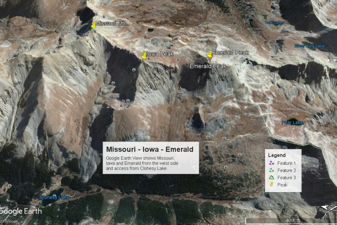
Emerald Peak is a Class 2 hike from the trailhead north of Clohesy Lake. From this start, the 8.5 mile loop hike can be easily completed in a day and will include the unranked Iowa Peak. A side trip to Missouri Mountain is also possible without adding much more elevation gain or distance. The only drawback is reaching the trailhead north of Clohesy Lake. This requires a 4WD or very good high clearance vehicle. Without access to such transportation, the hike would have to begin from near the creek crossing below Rockdale. This would add another 6 miles round-trip plus a wade across Clear Creek.
Emerald may also be combined with a trip up Missouri Gulch from Vicksburg and going over the summit of Missouri before continuing on to Emerald. This route will not be discussed here. 4WD would not be required for this access.
A third option is to backpack in along Pine Creek. This route covers 13.2 miles one-way. It would still be a Class 2 climb as the other possibilities. We will provide some detail about this access as an alternate for those who perhaps want to climb Harvard from Pine Creek along with Emerald. 4WD would not be required for this access.
Emerald Peak - S/SW Ridge Route
-
-
Rockdale/Clohesy Lake TH
From Leadville, drive south a little over 19 miles on HWY 24 to the turnoff for Clear Creek Reservoir (CR390) and head west. The turn is less than 2 miles south of "Granite." From Buena Vista, drive north just under 15 miles to the same turnoff. Drive west on the graded dirt road to Vicksburg and the Missouri Gulch Trailhead that gives access to Missouri, Belford & Oxford. From that trailhead, keep driving another 2.3miles to the turnoff on the south side of the road for Rockdale. The coordinates provided are for this turnoff. The road angles down past a small group of cabins and parking can be found at 9,940 ft. for passenger vehicles. For 4WD with good clearance, drive on down to Clear Creek, likely passing through some flooded area as you approach the creek. There is no bridge across Clear Creek here. Warning: This is a low water crossing. During runoff season, high water can make this crossing either very risky or impossible. It is often not safe until mid-July to make this crossing. If you do manage to get across, the road will climb up the south embankment steeply and then level off some. The climb out of the creek is often the roughest section of this road. The remainder of the drive is a slow 2.5 miles to the trailhead at 10,880 feet. Last time we were here, there was a large information sign. The trailhead stops short of Clohesy Lake because of private property, however, more recent reports indicate Clohesy Lake has now passed from private hands. If true, then the old roadbed that heads more directly to Clohesy Lake may once again be followed. The start of the bypass trail that has been in use for several years is at the south end of a clearing and into the forest a little. A locked gate prevents continuing on the road to the lake. A simple trail sign indicates the route for Missouri Peak to be to the left and a trail to the right leads to Huron Peak. Only the left (east) trail will take hikers beyond Clohesy Lake and farther up Lake Fork Creek. Coordinates for the end of vehicle access and this upper trailhead are: N 38° 57' 14.87" W 106° 24' 32.04".
Camping
The open meadow at the 4WD trailhead offers some at-large camping with no facilities. Otherwise, there are at-large spots on the drive in on CR390 and a somewhat designated campground at the west end of Clear Creek Reservoir. Camping can also be found around Vicksburg, but there is private property there and weekend hiking traffic makes it very difficult to find a place to camp unless you push on past Winfield.
Route Description
Year Climbed: 1988This route description assumes a start from the end of the 4WD road that terminates a little north of Clohesy Lake. Both one-way and round-trip mileage and elevation gain are measured from that starting point. If having to begin from the crossing of Clear Creek just below Rockdale, add another 1,000 feet of elevation gain and about 5 more miles walking distance.
From the 4WD trailhead about a third of a mile north of Clohesy Lake, walk south on the roadbed into the woods a little and take the left (east) fork trail labelled for Missouri Mountain. The trail wanders through the woods some, climbs a steep switchback then climbs less steeply as it heads south. In about .7 mile it comes to the intersection for the trail to Missouri Mtn. At this point, you've gained over 400 feet in elevation. Now you must lose most of that as you continue south and drop back down to near lake level, but well south of Clohesy Lake and the previous private property boundary. If it is true that the lake is no longer in private hands, you may be able to avoid the unnecessary elevation gain/loss by walking on the old roadbed in a more direct fashion to Clohesy Lake. At the lake, the trail #1461 for Pear Lake continues on the east side of the valley above the main stream. Continue on the trail for the next couple miles to the pass between the two drainages. Over those miles, the trail diminishes from an old vehicle track to just a one-lane trail. One thing that stands out about this trail from our multiple uses of it is how frequently small streams/rivulets cross it and the boggy mess that creates for much of the hike through the forested section. As the trail approaches the upper reaches of the valley, it moves out more to the valley center and into the willows. Though it's not difficult to pass through this willow section, it could get hikers rather wet if passing through right after a rain. The wide open basin of the upper valley feels very isolated. It is filled with tundra, lush grasses and scattered boulders. The trail will begin to fade in and out. If you lose it, simply head toward the pass and you'll likely come across it again.
Once at the dividing pass that overlooks Pear Lake, begin hiking east and NE following the somewhat indistinct ridge that becomes the SW ridge of Emerald. For several hundred feet, it's easy hiking across mostly tundra with scattered boulders and lots of wildflowers. You can continue on this type terrain to about 13,000 ft. where it changes over to a steeper scree/talus slope. Ascend another 600 feet through this mess utilizing faint trails. We advise that you not allow yourself to be drawn too far north. Best to aim for intercepting the south ridge of Emerald at it's southern most point before it drops into cliffs at 13,600 ft. Once on the south ridge, walk north on easier terrain to the summit. There is some tundra mostly on the west side of the ridge. At about 13,750 ft., hike more steeply again to ascend the summit cone of mostly rubble.
Emerald offers a good view of the collegiate 14ers nearby and also of Ice Mtn. and N. Apostle to the SW.
For the descent, we recommend either of these two possibilities: 1. Return as you came. This will increase overall mileage a little but is the easiest way back. 2. Continue on to Iowa Peak. Iowa is unranked because it does not rise enough from the saddle that connects it to Missouri, but it is at least, a named summit that some may prefer to tag. To do so descend north from Emerald through boulder rubble and talus to the connecting saddle. Once you gain the saddle, it becomes easy tundra strolling to the summit of Iowa, requiring a gain of about 490 feet. Pause for the view, then continue north along the ridge, favoring the east side to the low-point saddle between Missouri and Iowa at 13,580 ft. Turn west and descend the steep, scree couloir. At about 12,700 feet, you'll be able to find tundra again. Continue down the drainage on the north side of the center. Contour above willows on the north side of the developing stream (most years) and pick up the trail for Missouri Mtn. Follow this trail on back down toward Clohesy Lake through the abundant wildflowers followed by forest and then back to the trailhead at the end of the 4WD road. This descent description avoids the long trail hike out by reversing your route from Emerald, but has the disadvantage of a scree descent. Years ago, we did this couloir/scree descent. Overall, we covered well over 1,000 feet of elevation loss in about 10 minutes. Choose whatever best suits your abilities & comfort level.
As a final note, this entire route #2 description can be done in reverse but would require the tedious ascent of the scree slope. This could be avoided by taking the Missouri Mtn. trail all the way to the summit of that peak, then traversing south on the connecting ridge to Iowa, then Emerald.
Additional BETA
Links to other information, routes & trip reports for this peak that may be helpful. -