LoJ: Not Ranked / 13,863' Mount Spalding
Peak Summary
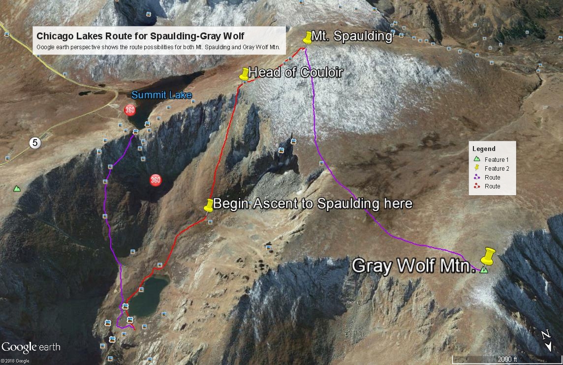
Mount Spalding is actually an unranked summit north of Mt. Evans that rises less then 300 feet from the saddle that connects it to Evans. Nevertheless, if you're cleaning out 13er summits around Mt. Evans, you'll likely want to go ahead and include Spalding and it's a very short hike from Summit Lake. Since you can drive to Summit Lake in most any passenger vehicle, the short, Class 2 or 2+ hike can be accomplished with no great difficulties. Spalding combines easily with Gray Wolf to the north. In addition, there's a much more interesting and "sporting" route for Spalding/Gray Wolf that involves a hike into a more isolated valley with some beautiful lakes to enjoy and the climb out of that valley can involve at least some brief Class 3 scrambling.
Mt. Spalding from Guanella Pass Route
-
-
Guanella Pass TH
The trailhead is either of the two large parking areas near the summit of Guanella Pass. The trail to use is the one for Mt. Bierstadt on the east side of the road.
From I-70, take the Georgetown Exit 228 and drive east on 15th St. to a traffic circle. Proceed 1/4 of the way through the circle and exit south onto Argentine St. Drive south on Argentine then turn left onto 11th St. Turn right onto Rose St. and head south into the main part of town. Continue all the way to 2nd St. where you'll turn left and will be on SH 381. This is the Guanella Pass Road. Follow it south for 10 miles to the summit of Guanella Pass where there are two large, paved parking areas. On weekends, these can fill up completely and you'll find dozens of vehicles parked along the roadway. From Georgetown the road is paved all the way.
From US 285, take the turnoff for Guanella Pass at the town of Grant, west of Bailey. On this side, the road number is CR 62. Drive north for 12 miles to the pass and park where you find room. The road on this side is largely paved, but in generally worse shape than the Georgetown side.
Camping
National Forest campgrounds on the Georgetown side include: Clear Lake and Silver Lake. On the Grant side of the pass, campgrounds include Geneva Park, Burning Bear and Whiteside. All are fee-based and have vault toilets. Geneva Park and Whiteside do not have water. If you cannot find a camping spot at any of these (quite possible on weekends), then there are numerous at-large spots to choose from and car-camp pullouts. Just be careful to avoid private property and follow forest service rules.
Route Description
Year Climbed: 1987From the lower parking lot at Guanella Pass, walk to the south end of the lot and head out on the Mt. Bierstadt Trail which goes south briefly, then turns east. After the trail passes below the south end of an unnamed lake, keep on the same trail until you reach the crossing of Scott Gomer Creek. Instead of crossing the creek, depart the trail and head NE. Coordinates for departing the trail should be close to these: N 39° 35' 38.81" W 105° 41' 51.22". As you walk NE the terrain stays generally open with avoidable groves of willows, but still plenty of marshy areas. You want to aim for an area of trees that grow up a slope north of Scott Gomer Creek. Aim for this second set of coordinates: N 39° 35' 53.56" W 105° 41' 32.34". Elevation 11,550 ft. Getting into these trees will help avoid the willows. Head up the steepening slope to an unnamed pond at 11,860 ft. that's just east of the Forest Boundary line on the USGS map. Continue up into the broad basin which holds the north fork of Scott Gomer Creek. Once above the cliff band that leads over to The Sawtooth, head for the west ridge of Spalding and follow it to the summit. Once above the trees, most of the terrain is tundra with increasing rock/boulders as you approach the summit of Spalding.
Return as you came (or thereabouts) or continue on to Gray Wolf.
Additional BETA
Links to other information, routes & trip reports for this peak that may be helpful. -
