LoJ: #292 (Pre-LiDAR #290) / 13,450' Apache Peak
Peak Summary
With passenger car access on the Front Range, Apache and Navajo Peaks in the Indian Peaks Wilderness are a very popular day hike destination for peakbaggers and climbers. The route we took for Apache goes at no more than a Class 2+. Done earlier season, it was a snow ascent that required ice axe at a minimum. Crampons or mico-spikes quite helpful. Pre-Lidar elevation was 13,441.
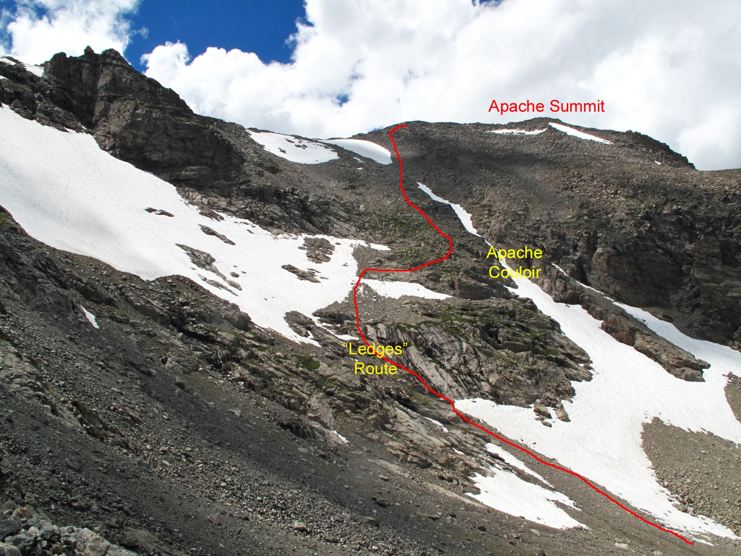
Apache Peak ESE Couloir or "Ledges" Route Route
-
-
Brainard Lakes - Long Lake TH
Because there are so many possible ways to do this, and depending on where on the Front Range many people may live, we'll leave it to you to figure out how to get to state highway 119, also known as the "Peak-to-Peak" highway which along with SH72 and SH7 connects Blackhawk, Nederland, Ward, Allenspark and Estes Park. If coming from the west on I-70, you'll probably want to take the newer Central City cutoff just east of Idaho Springs, to Central City, Blackhawk and SH119. Out of Estes Park, the road you want is SH7. North of Nederland, SH119 switches to SH72. The goal is to get to Ward. Just north of the turn for Ward, turn west onto the Brainard Lakes Road (FR112). The poorly-maintained, paved road climbs up some switchbacks and then heads generally west and comes to a new, large parking area on the right with facilities. This new lot serves as a trailhead for some trails that take you on back to the Brainard Lakes, but starting from here will add significantly to overall mileage if heading back to the main group of peaks. Just past this lot, there is an entry, "fee" station. Cost for admission is $10 with various government issued passes allowing free access such as a "Senior Pass." During off hours, you'll need to self-register. Shuttles can run hikers farther up valley.
Continuing past the entry station, in a couple more miles you'll come to another turn on the right, just before the main Brainard Lake for the Pawnee Campground, and just past there will be another road on the right that will take visitors into yet another large parking area with toilet & water facilities and a wheelchair accessible picnic area. Drive on the main road west to the west end of Brainard Lake. The road to the two parking lots crosses S. St. Vrain Creek then forks. Turn left twice for the Long Lake parking lot. This will provide access to Apache and Navajo Peaks. Being the closest parking to the main trails, these lots fill up the earliest.
WARNING: Because of the popularity of this area and its close proximity to the recreational-seeking hordes of the Front Range, the parking for Brainard Lakes quickly fills on summer weekends to the point where later arrivers may have to park far back from the trailheads. Arrive Early! Think - Longs Peak parking problems.
Camping
The only close-by camping is the Brainard Lakes "Pawnee" Campground, a fee area maintained by the Forest Service. Reservations can be made at Recreation.gov, months in advance. Finding an open campsite between Memorial Day to Labor Day can be difficult. Actual open dates posted for 2021 are 6/25 - 9/12/21. There are 47 sites of various kinds, vault toilets and water. Fees run from $23 to $46. No camping is allowed beyond the entry station in any other area. The Indian Peaks Wilderness does allow backcountry camping, but by permit only. If that's your choice, you can begin your research at the link below. Because of the mixture of private and forest service land all around Ward, it's very difficult to find any at-large spot where you can pull off and spend the night without possibly violating someone's private property or being so close to such, that you have no privacy. The nearest other National Forest campgrounds are Camp Dick (less than 10 miles north on 72) and the Rainbow Lakes, south on 72 and then up CR116.
http://www.fs.usda.gov/detail/arp/passes-permits/?cid=fsm91_058238
Campsite Locations
Pawnee Campground › N 40° 04' 45.31", W 105°34' 02.00"Elevation 10, 400 ft.
Click thumbnail to view full-size photo + captionRoute Description
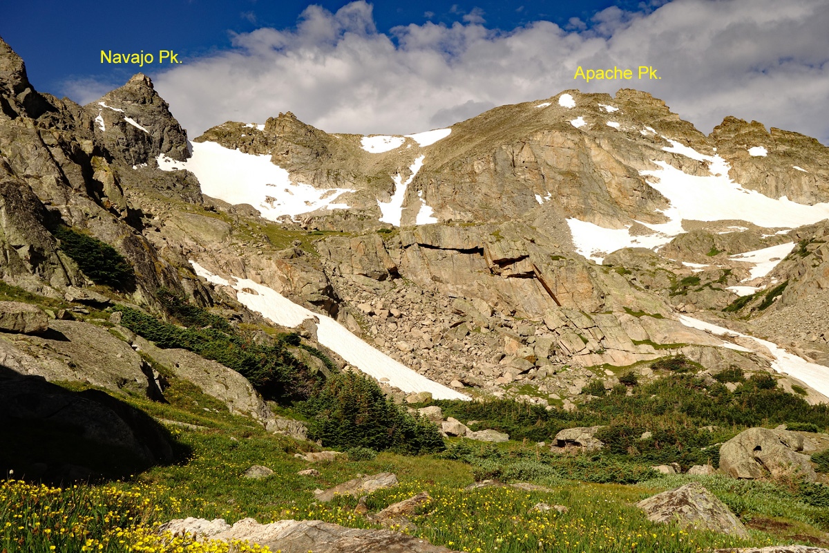
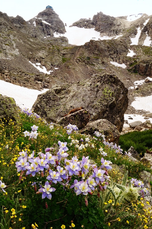
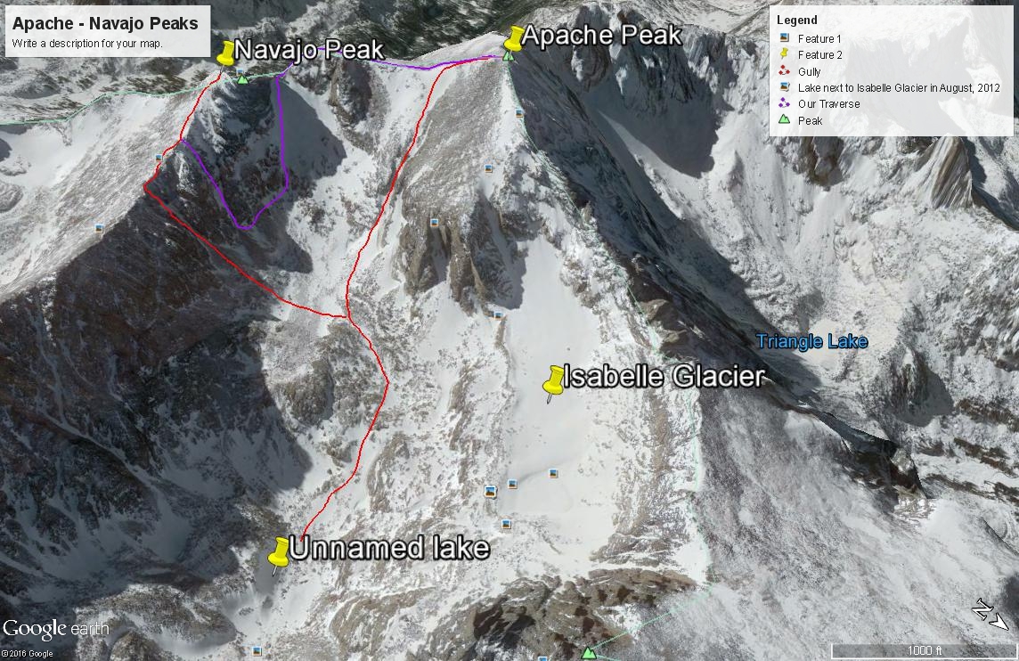
Year Climbed: 1998From the Long Lake trailhead parking, walk on the well-used trail to Long Lake through forest. Compared to the Mitchell Lake/Blue Lake trail, this Long Lake trail is in much better shape. The trail initially takes you near the lake outlet in about .2 mile. After that, it goes along the north shore, in the forest and stays well away from the lake. Follow the trail around the lake on the north shore for a mile to a trail intersection. Stay left here for the trail marked "Isabelle Glacier." Continue another mile on trail to Lake Isabelle staying on the north side of the lake. The trail gains elevation more steeply just before the lake, then follows close to the shore through some willowy sections and then climbs a little before dropping you back down through a rubble area back to the shore. Beyond Lake Isabelle, there are three successive basins with intervening, steeper sections to ascend. Just beyond Lake Isabelle, the trail ascends on some switchbacks next to a beautiful cascading stream. In the next basin, the trail meanders over to the south side of the basin, crossing the main stream and becoming somewhat lost in that section by following the stream course briefly. After that, the trail ascends up to the next basin which holds a small, unnamed lake at the foot of Shoshone Peak. By the time you reach here, most of the terrain is rocky with plenty of boulder-talus. In earlier season, expect to be mostly on snow from here on out. The trail to "Isabelle Glacier" will no longer be of use here. Continue WSW either off-trail or following faint climbers trails to a yet higher basin at 12,100 filled with more boulder-talus. Now, you are at the foot of Apache and Navajo and it's time to make a decision as to which of these two summits to climb first or which you'll be doing alone as a single peak day. You may also want to make mental note of "Airplane Gully" for future reference, especially if you plan on including Navajo in your plans for the day.
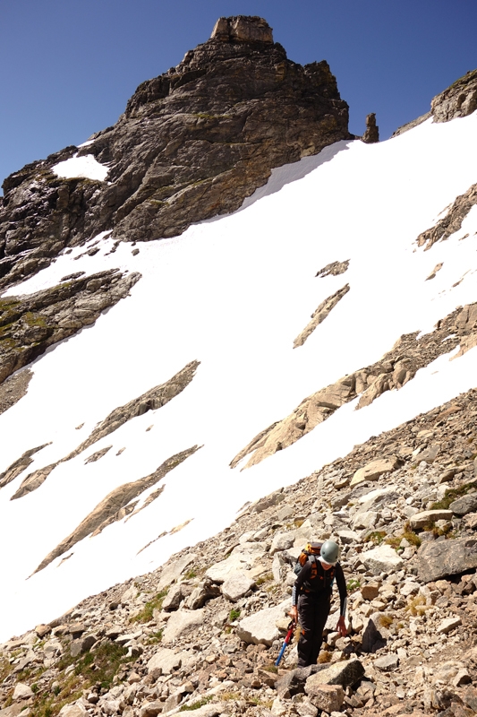
A note before continuing: In 1998, Gerry Roach published his book on climbing in the Indian Peaks, the year in which we climbed Apache and Navajo. If only we had known about that book at the time! We did this climb with very little beta to go on. With that said, our choice that day was to head directly up a snow-filled couloir that topped out just a little south of the Apache summit. This route has become known as the "Apache Couloir." We did this route about July 8th. The couloir was completely snow-filled. In fact, from Lake Isabelle on, we had been on snow most of the time. The couloir probably averages 35 - 45 degrees. Ice axe is mandatory. Crampons or micro spikes are welcome. We had only brought ice axes. The east-facing couloir will soften up quickly in the morning so step-making should not be a problem. Watch for a cornice at the head. You don't want that releasing while you're in the gully. The 1,000 feet of gain is just a long grunt. We rate it Class 2+ because you at least need to know what you're doing with an ice axe and how to handle yourself on steeper snow. Gerry Roach classifies this as a "classic" route. In mid-summer, surrounded by almost all rock and snow/ice, it certainly has an alpine feel about it.
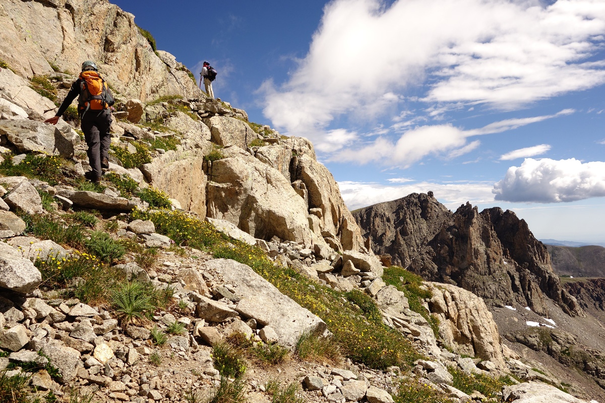
Once you top out at the head of the couloir, it's an easy stroll over scree and talus to the summit just a short distance away. If you are averse to a snow route, then perhaps the easiest other way up is called the "East Ledges" route. Rated at Class 2+, the route begins in the same boulder-filled basin at 12,100 feet. (Snow filled in earlier season.) We returned in 2016 to climb Apache (and Navajo) by starting up this route. Head uphill in the direction of the large snowfield below the Navajo-Apache saddle. Some call this Navajo Glacier. A little below the snowfield, turn right (north) and follow a complex system of rock ledges to gain the south ridge of Apache not far from its true summit. In mid-July 2016, we could complete about 98% of this route off snow. Frankly, snow would have been easier than the talus. About mid way up, we found one very distinct ledge that we followed uphill to the north which deposited us on a slope of mostly broken rocks and boulders at times. We found it easiest to just head mostly directly straight up to the Apache south ridge. In essence, this ledges system just parallels the Apache Couloir on what will usually be exposed rock on the south side. The ledges consist of rock, some talus, gravel and boulder talus and some occasional tundra. Once on the south ridge of Apache, walk on easier but still rocky terrain, north to the summit.
Once on top, soak in the amazing view. To the east you see the broad expanse of the eastern plains of Colorado and much of the front range corridor. North and south, you see all the Indian Peaks summits and all the way into Rocky Mountain NP. To the west, you can see off toward Granby and the ranges beyond there. Now, make a decision as to whether or not to continue to Navajo Peak. If you do so, you need to be prepared for Class 3 scrambling, and a Class 4 ascent on Navajo. Some may wish to have a rope. If just heading back down, for those with ice axe and necessary skills, descend back down the Apache Couloir for an amazing glissade. If not skilled and/or somewhat terrified by such, follow the "East Ledges" route back down.
Additional BETA
Links to other information, routes & trip reports for this peak that may be helpful. -