LoJ: #239 (Pre-LiDAR #237) / 13,530' Boulder Mountain
Peak Summary
A mostly Class 1, barely Class 2 hike that can be easily combined in the same day with Mount Mamma. 4WD with good clearance can shorten the mileage, but why not keep it sporting? Much of the mountain can be ascended on an old mining road. The remainder involves grassy tundra, and of course, the inevitable rocky talus. Lidar measurements added 2 more feet.
Boulder Mtn NE Ridge & Slopes Route
-
-
Baldwin Creek TH
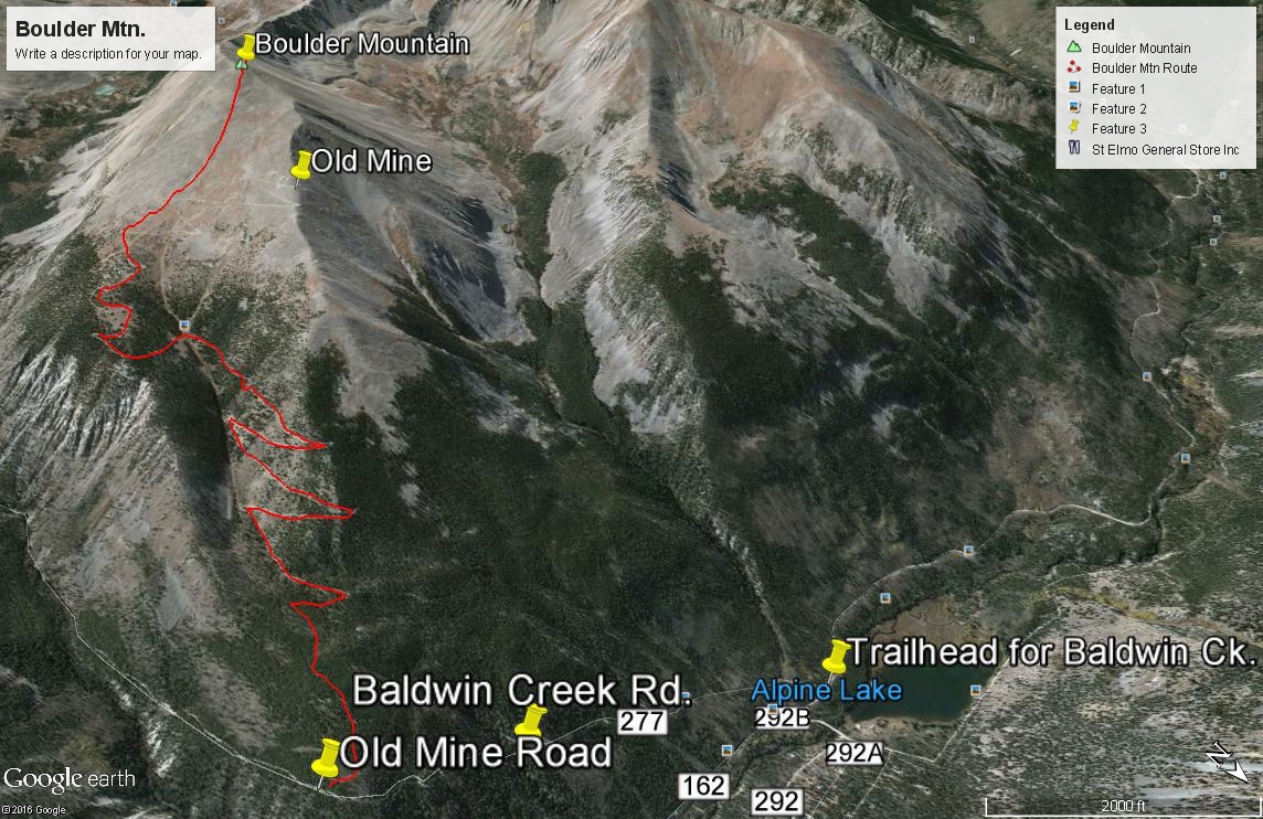
From the center of town in Buena Vista at the US285 and CR306 intersection, drive south 8.1 miles south on US285 and turn right onto CR162. If coming from Johnson's Corner, drive south 5.7 miles to CR162. This is also known as "Chalk Creek Drive" and heads up towards the Mt. Princeton Hot Springs and takes you below the spectacular Mt. Princeton Chalk cliffs. Drive west on this road for 12.5 miles to the townsite of Alpine. Or measure from the end of the pavement 2.0 miles. Across from Alpine Reservoir is the turnoff for FR277 that heads up Baldwin Creek. There is very limited parking here. You may be able to find some parking around Alpine, but most everything is private property, so be careful where you park. Summer of 2019, we noticed a lot of vehicles parked along the road both before & after the trailhead.
It is possible to drive up the Baldwin Creek road if you have 4WD or 2WD with very good clearance. Every time we've been on this road (and that's quite a few), we have found it tediously rocky and slow and with more and more 4WD's, ATV's, etc., it is not likely to improve. We were last here summer of 2019 and took a quick look at the road condition. Personally - we would not advise going up this road any longer unless you have 4WD with excellent clearance. That said, we did notice signs indicating that some actual work (road repair) was going on, so perhaps there will be some improvements. This trailhead will be somewhat unique in having an "Upper Trailhead" as well. This is where FR277 and FR278 split with FR278 heading off to the left (SE) and immediately crossing Baldwin Creek. FR278 heads up onto Mt. Antero and eventually crosses over into Browns Creek. FR277 continues SW up along Baldwin Creek to a switchback where a trail to Baldwin Lake heads off. Trails Illustrated shows the road ending there now as does the Forest Service map. The coordinates for the FR277/FR278 intersection are N 38° 40' 57.11 W 106° 16' 22.56". Elevation there is 10,870 ft. The distance from the lower TH is 3.0 miles.
Camping
At-large camping opportunities along CR162 are very limited, mainly because of all the private property. There are National Forest, fee-based campgrounds along the way. They are: "Boot Leg" at 8,400ft. with 6 units & no water; Mt. Princeton at 8,000 ft. with 17 units; Chalk Lake at 8,700 ft. with 21 units and past the Baldwin Creek road and up toward St. Elmo, the Iron City CG at 9,900 ft. You can expect all of these to fill up on weekends. This road leading up to St. Elmo is a popular weekend destination for all types of recreationists.
Near the FR277/FR278 intersection, there are some limited, primitive camping opportunities. Drive just a short distance farther on FR277 toward Baldwin Lake and there is a good area with multiple campsites at the coordinates provided below. There are also some good primitive sites on FR278 just after crossing Baldwin Creek.
Campsite Locations
Baldwin Creek › N 38° 40' 50.08", W 106° 16' 29.15"Elevation 10,900 ft.Iron City › N 38° 42' 30.17", W 106° 20' 12.41"Elevation 9,900 ft. Turnoff is along the short stretch of road that leads down to St. Elmo. This campground has 15 sites, one vault toilet and an untreated water pump that we could not get to work.
Route Description
Year Climbed: 2000From the beginning of the Baldwin Creek road, drive or hike SE up the road for about 1.1 mile. In that vicinity, there will be two old mining roads turning off on the right (west). In 2000, we found the first road to be open while the second was closed. Both eventually join up with each other. The 2011 San Isabel NF map does not even show either of these two roads, so we suspect they are both closed now to vehicle access by the public, however, Trails.com has a report on the road as accessible to ATV's and 4WD vehicles all the way to the mine. They report the road as very rough & rocky with dangerous drop-offs and tight switchbacks.
We took the second of the two roads. The old rough road climbed steadily to about 10,700 feet where it leveled off some with good campsites (if you can drive to them). Continue following the road at least as far as the second switchback. If you want, you can depart the road here and simply follow the NE ridge of the peak in the direction of the summit by staying on the edge of the denser trees hiking through open forest. Above treeline, continue on mostly lush, greasy tundra to the old mine and from the mine, continue hiking SSW up the ridge to the summit. The terrain will change from tundra to embedded rock and finally broken rock.
If you don't wish to take the direct approach, stay on the old mining road as it cuts over at 11,700 feet to a minor ridge east and then follow it through trees until it turns west and breaks out of the trees at 12,100 ft. Once out of the trees, you'll probably tire of following the road with all its switchbacks, so just make a beeline across the tundra in a SW direction toward the summit. It's 3.5 miles from the trailhead start to the summit following the old mining road to treeline. If you follow the NE ridge more directly, you may save a half mile or so. Since the mine is on a private in-holding, there may be private property issues in and around the mine.
-
