LoJ: #206 (Pre-LiDAR #209) / 13,575' Broken Hand Peak

Peak Summary
A classic, Sangre de Cristo hike. With the extensive work done by the Colorado 14er Initiative over recent years, there is now maintained trail access for much of this climb. Class 2+ work will gain you this summit with outstanding views of the Crestones, particularly the Needle. However, a 2.5 mile stretch of the road up South Colony Creek from the creek crossing has been closed so be prepared for a longer hike-in or backpack access. Combine this one with "Crestolita" for some additional challenge. Pre-Lidar elevation was 13,573.
Broken Hand Peak Route
-
-
South Colony TH
From the town of Westcliffe: Drive south on HWY 69 for 4.5 miles and turn right onto Colfax Lane (CR119). Proceed about 5.5 miles on this partially paved and graded dirt road to an intersection where you must turn right or left. Go right (west) on CR120 and in about one more mile, if in a low clearance passenger car, park at a fence line. This is referred to by some as the "lower trailhead." If you have a better clearance vehicle (CRV, Outbacks or better) with care you can drive another 2.5 miles to the "upper trailhead" close to and before where the road crosses South Colony Creek. This last 2.5 miles has deteriorated significantly over the last few years. The Forest Service has put in a parking area here that they say can hold about 50 vehicles. On summer weekends, you may find even this amount to be insufficient. Also, the FS has considered introducing a "use fee" of $20, however at the date of this writing, the idea appears to be in limbo. Best to go prepared, however. From the parking area, a bridge takes hikers over South Colony Creek so no need to prepare for wading.
Camping
On the 2.5 mile drive into the upper trailhead, there are some at-large spots available and then at the trailhead, the FS has installed 4 - 5 camp spots that have tent platforms and fire rings. There is presently no fee for using these spots. Wag-bags are supposed to be available from a dispensary of some kind to help with the human waste problem. There are no vault toilet facilities. Here's a hint for those peakbaggers spending multiple days in the Westcliffe area and in need of a shower: The Westcliffe Inn, a little south of town on HWY 69, may offer use of their showers for a small fee. We last availed ourselves of this in 2009. Stop in and inquire if they are still open.
Campsite Locations
South Colony Creek › N 37° 58' 34.74", W 105° 30' 20.75"
-
From South Colony TH via Upper South Colony Trailhead
From the upper trailhead at the crossing to the north side of South Colony Creek, walk up the old roadbed for 2.8 miles to the old terminus for the road where it crossed the main creek. Last time we were on this road in 2009, we could still drive it and sections of it were unrelentingly rocky. Still, you should be able to walk this access in about an hour. Where there use to be parking at the upper terminus, look for the "shortcut" trail that heads more directly west to the lower and upper South Colony Lakes. This trail is the main access for Humboldt or Kit Carson if heading in that direction.
Camping
There is plenty of camping available in the vicinity of where the road used to end at 11,000 ft. and all along the trail "shortcut" trail to the lakes and at the lakes.
Open This Approach in a New Window
Route Description
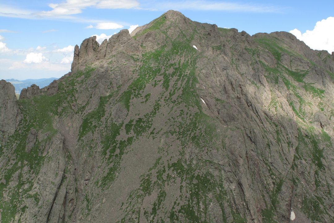
Year Climbed: 1997From where the old road ended at the creek crossing at 11,000 ft., choose either of the two trails that will take you to the lower of the South Colony Lakes. The trail that follows the creek SW is a little longer and doesn't have the great views of Crestone Needle until it almost reaches the lower lake. From the lower lake, pick up the trail to Broken Hand Pass which is marked by a sign indicating this to be the "standard" approach for the Needle. Extensive work done by the Colorado 14er Initiative over the last several years has removed the guesswork from reaching Broken Hand Pass. A well-defined trail leads all the way up now and has reduced the difficulty of the 400 foot talus ascent to the top of the pass. Here, you'll find a large wood and cable structure used by local rescue to bring down injured or dead climbers from off the Crestones.
Once at the top of Broken Hand Pass, descend about 200 feet on the trail toward Cottonwood Lake before contouring SSE along the flank of Broken Hand Peak to avoid some rocky outcrops for a short distance. Turn up a shallow gully that's mostly tundra-filled and begin your ascent in earnest. Along the way, you may switch to another similar gully as you weave your way around avoiding cliffs and towers of conglomerated rock. Most of the ascent, if you choose carefully, can be accomplished on tundra, however, the small summit is rockier.
For an easy descent, head from the summit directly along the ridge to the saddle between Broken Hand and Crestolita on mostly tundra. At the saddle, you can then pick up a trail that contours back north and intersects the trail coming up from Cottonwood Lake and return to Broken Hand Pass. The ascent to the summit from the terminus of the old road is about 2 - 3 hours. From the upper trailhead, add at least another hour.
Additional BETA
Links to other information, routes & trip reports for this peak that may be helpful. -