LoJ: #258 (Pre-LiDAR #263) / 13,503' Graystone Peak
Peak Summary
A Class 2+ peak or possibly a little 3rd class scrambling depending on exact route taken that combines well with Arrow, Vestal, Electric or Mt. Garfield, depending on access and route taken. Access to this peak for most will likely involve a backpack trip. The closest access point by foot is the Molas trailhead near Molas Pass which connects with the Colorado Trail down to the Animas River, then continues up Elk Creek to the east. See separate approach description for details. Lidar measurements added 14 feet of elevation to this summit.
Graystone East Ridge Approach Route

-
-
Molas Pass - Elk Park Trailhead
From the highway intersection just west of Silverton, CO, drive south on US550 in the direction of Molas Pass for 5.3 miles. About .6 mile, or at 5.3 miles total, after the turnoff for the Molas Lake there is a turnoff to the left into the trailhead parking area, accessible to 2WD vehicles. The dirt parking lot may be muddy at times and have a few potholes to avoid. There is usually plenty of room to park here, but can get a little full on weekends.
If coming from Durango, drive north on US550 over Coal Bank Pass and Molas Pass. After cresting Molas Pass, the turnoff for the trailhead will be 1.1 mile further north and on the right. The drive from Durango will take about an hour.
Camping
You can probably vehicle camp at the trailhead but there is no immediate toilet facility. You could also hike south along the trail a short distance from the TH and pitch a tent. There is a vault toilet back at the top of Molas Pass or at the turnoff for Molas Lake, you can drive down to the park and pay a fee to camp where there are not only vault toilets, but also hot showers for $5.00. There is also a fee campground at "Little Molas Lake," which is on a graded dirt road that turns off to the west, from the highway back towards Molas Pass. So overall, there are plenty of camping opportunities in the immediate vicinity.
Click thumbnail to view full-size photo + captionRoute Description
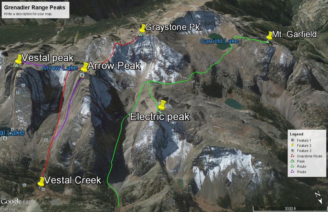
Year Climbed: 1992The following summary will apply to all the peaks accessible from Vestal Creek. These include: Peaks Two and Three, The Trinities, Vestal, Arrow, Electric, Graystone, Point Pun (unranked) and Garfield. In describing the routes for all these peaks, we have used the beaver ponds on the Elk Creek trail as the "base camp" starting point. Mileages and elevation gain are measured from there for each. However, for those with the strength and fortitude, you can continue the backpack portion of the trip by heading up the unmaintained and sometimes confusing Vestal Creek Trail. That hike will be included with each summit in this area as part of the "approach." Not only is the Vestal trail confusing at times with multiple tracks to follow, it is very steep and also harbors a large number of fallen logs to cross. The campsites in upper Vestal Creek are also known for their aggressive and camp-destroying marmots. Protect your food supply accordingly and even your gear as well. In 1992, we had marmots chew their way into our tent, then they both slept and defecated on our sleeping bags. In addition, they completely destroyed a pair of shorts we had left outside to air out, chewed on our packs and socks left out and they chewed through one of the tubes for our water filter. In short, they were attracted to anything that had salt on it.
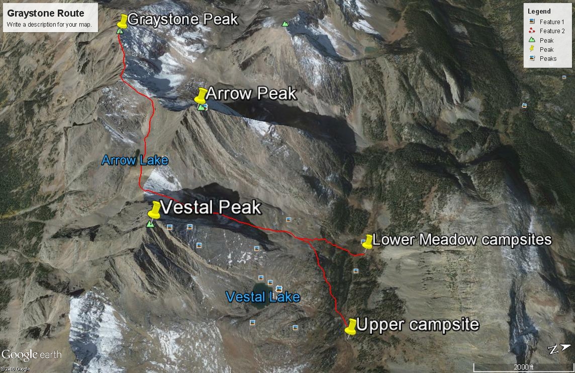
Graystone is in the unique position where you could sequence a climb of it with either a day of Arrow/Vestal/Graystone or Garfield/Electric/Graystone. This description assumes the former sequence. To climb Graystone, begin from either the "lower meadow" along Vestal Creek at 11,300 feet or from the higher camp at 11,760 ft. From the lower meadow camp, you'll need to ascend SSW steeply for 600 feet to gain the valley between Arrow and Vestal. At the time we did this in 1992, it something of a bushwhack that will take you through trees, willows, rock benches and minor cliffs, and tundra. Roach now describes a "strong climber's trail" heading into the basin now. In 1992, we saw no evidence of such. If coming from the higher camp. you'll need to contour back to the west across rock benches interspersed with tundra and grassy shelves to the same valley. Once in the valley between Arrow and Vestal, head SSW to the saddle that joins the two peaks. Most of this valley is occupied by a rock glacier with little tundra for reprieve from the relentless boulder hopping, etc. Obtaining the saddle will take you through talus & scree as well, or possibly snow earlier in the season. Ice axe would be handy then.
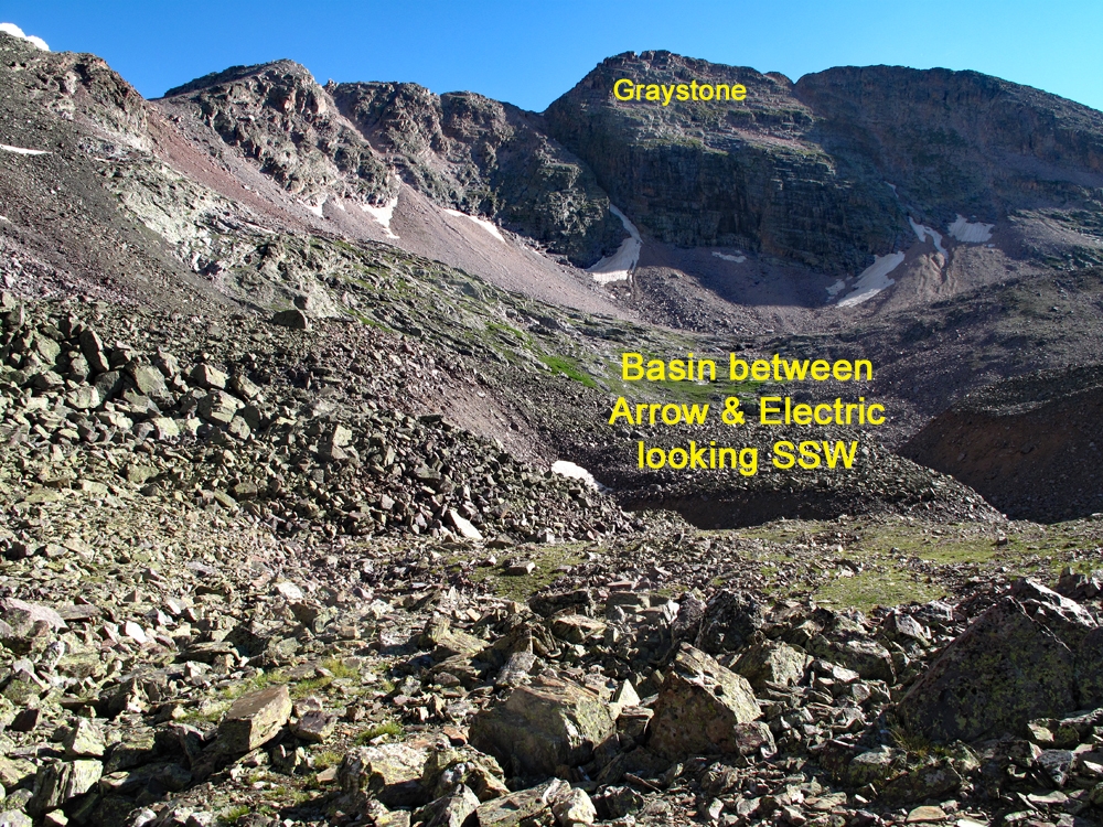
From the saddle, lose 200 feet in elevation and drop on down to near Arrow Lake. Contour west over to the saddle between Arrow and Graystone at 12,980 ft. hiking up plenty of rocky rubble. Follow the fairly broad ridge SW to intersect the main east-west running ridge of Graystone. As you approach that ridge, veer right to avoid unnecessary elevation gain unless you want to tag Pt. 13,404 to the SE. Continue west along the rubbly ridge to the Graystone summit. In earlier season, you may have to cross a couple of corniced snowbanks at the head of some gullies. We found ourselves driven off the ridge crest to the south side at one point where we had to cross some steep gullies and then re-ascend to the summit ridge, but nothing exceeded some good Class 2+. Though Graystone is not ranked among the two hundred highest summits, it is certainly worth consideration to climb, especially when you consider the effort it takes to get back into this area. Don't leave it "hanging." At the time we did it, we were only working on the top 200 summits with nary a thought about climbing all the 13ers some day. We are most glad we went ahead and included Graystone with Arrow and Vestal on that trip.
For your return trip, go back to the saddle SW of Arrow and west of Arrow Lake. You can retrace your ascent route back to whichever campsite you've used or the Vestal Creek trail. Or, from the saddle, you could also drop NW into the valley between Arrow and Electric. This rock-filled, slow-going valley can drop you out lower down on the Vestal Creek trail at about 11,100 ft.
Additional BETA
Links to other information, routes & trip reports for this peak that may be helpful. -